

Vicinity Location: The trailhead is about 80 miles southeast of Portland, Oregon in the Willamette National Forest.
Directions:
From Portland, take I-5 south for about 46 miles, driving through Salem.
Take exit 253 for OR-22 E toward Detroit Lake/Bend and drive 0.3 mile to the traffic light, choosing one of the left lanes.
Turn left onto OR-22 E/Mission St SE, crossing over I-5 and continue to follow OR-22 E for 77 miles.
Turn left into the Maxwell Butte Sno-Park also known as Maxwell Sno-Park. Overnight parking is at the far end of the parking area.
A current Sno-Park permit is required to be displayed between November 1 and April 30. Oregon permits cost $4 a day, $9 for three days or $25 for the season and can be bought on-line.
There is an outhouse at the trailhead.
You can see avalanche forecasts here: Northwest Avalanche Center
National Weather Service Snow Level forecast: Northern Oregon Cascades
Trail:
Maxwell Butte Trail #3391. Connections to Lava Lakes Trail #3433 and Eight Lakes Basin Trail.
Trail Maps:
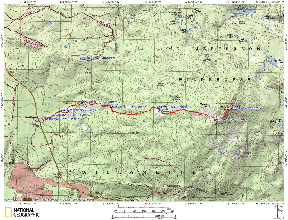
National Forest map, Topo Map, Download Garmin .gpx file
Length and Elevation:
9.3 miles roundtrip. Elevation at the trailhead is 3,625 feet. Total gain is 2,650 feet and loss is 2,650 feet. Highest elevation is 6,195 feet and the lowest elevation is 2,650 feet. Elevation change to the top of the butte is 2,420 feet elevation gain and 150 feet of elevation loss.
Review: 1/28/2017
We left on a Friday evening and stayed at riverside Campground along the Santiam River. The campground was closed but there was a place plowed in front of the gate for us to park. We wanted to be able to get a fairly early start in the morning. There was about two feet of snow on the ground as we walked past the locked restrooms. After a couple of beers the sounds of the river were our lullaby for bed.
Saturday made breakfast at the campground then drove about 15 miles to Maxwell Butte Sno-Park. We were one of the first ones there for the day and found the overnight parking spots at the north end of the parking lot.
The trail starts from near the north east corner of the parking lot. It is marked with blue diamonds and fairly easy to find. It is a little narrow being hemmed in by some trees.
The trail rises gently for the first mile or so as it passes through the forest of fir, pine and Hemlock with some monstrous Douglas Fir trees along the way.
The trails are very well marked with trail signs showing your position and a map of the area trails. As we continued the forest got a little denser and the trail got a little steeper.
There were a few places with deadfall in the trail but they were easy to get around. After a couple of miles we got to Twin Lakes and stopped for lunch. No one else had been out this way yet for the day. While we were eating lunch a couple of groups of people came by. One of the groups was also heading for Maxwell Butte but just for the day and the other group had gone the wrong way. The Maxwell Butte group was willing to break trail for us and we were glad to let them go ahead because the weather had warmed and the sticky snow made our snowshoes feel like each one weighed three pounds.
This section has a lot of dead and sickly trees and makes for a grim trudge up the path but after a mile the trees become healthy again.
We reached the point where we wanted to leave the trail and use the southwest ridge to ascend to the top of the butte. It took some route finding but there is a nice way to get up to the ridge keeping an open route between the trees. As you climb, the ridge narrows and becomes pretty steep but never really a knife-edge. The snow was icy here from falling off the trees and freezing but our snowshoes slipped a little in the steepest parts. The ridge was never steep enough that we had to pull ourselves up with our hands. We were able to walk up the entire ridge though there were some places with voids around snow covered rocks and trees so step carefully on the narrow parts of the ridge.
The views to the south and east really open up once you get onto the ridge. As with any climb, the ridge eventually flattened out and it would be pretty easy travel if we weren’t so tired from breaking trail up the steep ridge in the wet snow.
There is a big open bowl just west from the top of the butte however we found a place along the top of the ridge where we could walk a few steps and see the Three Sisters. I made my snow cave in a consolidated snowdrift and Jeremiah and Sean set up their tents without having to work too hard to level their sites.
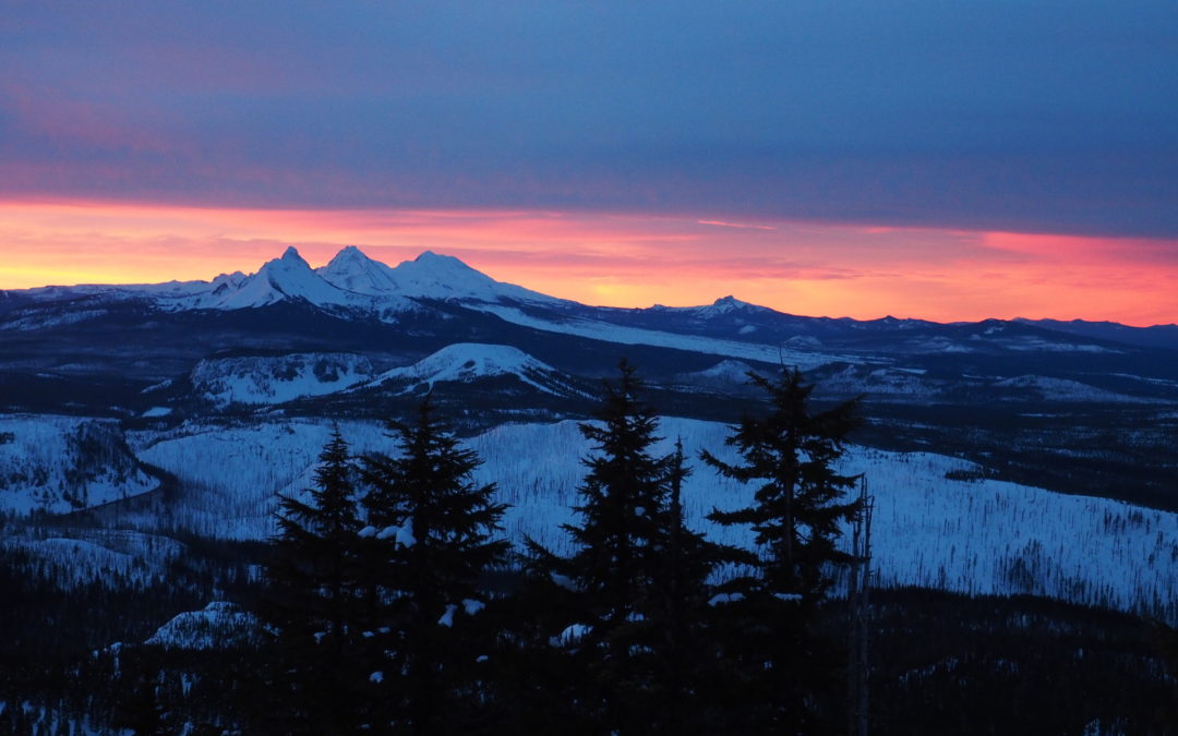
We walked another .25 mile to the very top of the butte, which has an open flat area where you can see Mt. Jefferson, Three-fingered Jack, The Three Sisters and all the mountains around. We could see as far as Diamond Peak to the south and Mt. Hood to the north. We watched a beautiful sunset and headed back to camp for dinner.
Sean and I went to bed early but Jeremiah stayed awake for a few more hours.
The next morning Jeremiah and I were treated to a fantastic sunrise behind Black Butte and lighting up The Three Sisters and making the sky look like fire all the way to the south.
After breakfast we broke camp and I knocked down the blocks to my snow cave. The snow was firm going downhill in the morning and it didn’t take long to get past the icy steep spot we climbed up the day before. We travelled fast going downhill on the firm snow. It was only a couple of hours back to Twin Lakes where we stopped again to have snacks and admire views of Maxwell Butte, remembering how we had just been way up there. From the lakes it is really hard to see the open areas on top and even to see exactly where we were on the butte.
On the way back we turned left at Marker 4 and took Park Loop. This trail is more open than the old Forest Service Road and is more popular with skiers so we made a snowshoe trail on the right side where most of the way and stayed out of the ski track. We rejoined the main trail at Marker 2 and went the remaining 0.3 mile to the parking lot.
This was a very strenuous trip due to breaking trail, steep uphill climb, route finding, and sticky snow. The views from the top are spectacular from several spots on the butte.
Enjoy the photos!!
Gallery Pics
Switchback Steve
Recent Comments