
Vicinity Location: Willamette National Forest
Location: The trailhead is 50 miles east of Eugene, OR near the community of McKenzie Bridge.
Directions:
Directions: Drive towards Eugene, OR and take Highway 126 for 50 miles to McKenzie Bridge. From there, continue east for about 1.5 miles to the lower trailhead and there is a parking area on the left side of the road.
The best arrangement to backpack the trail is to arrange a shuttle and have them meet you at the trailhead then shuttle you to the trailhead just north of Clear Lake.
A Northwest Forest Pass is required at this location.
An outhouse is available at the trailheads.
Length and Elevation: About 27 miles with part of the Waterfalls Loop
Day1
Trailhead Elevation: 3,150
12 miles
Night 1 elevation: 2,306
Gain 1,661 Loss 2,497
Day 2
9.1 miles
Night 2 elevation: 1,803
Gain 683 Loss 1,116
Day 3
8.25 miles
Trailhead Elevation: 1,500
Gain 322 Loss 424
Trail:
McKenzie River Trail #3507
Trail Maps:
Topo Map, National Forest Service Map, Download Garmin .gpx file
Review: 5/20/2016
This is part of the National Recreation Trails system. Portions of the trail above Scott Creek also travel through part of the National Wild and Scenic River system, which was designated for the upper McKenzie in 1988.
Robert, PJ, Larry, Randee, and myself met and departed Portland at 6 a.m. for the trip. We stopped in Salem for a hearty breakfast of Pancakes and omelettes. After having plenty of food and coffee we headed to McKenzie bridge to meet our shuttle. There was some confusion about the meeting location but after several texts with the Guide Service we parked our car at the lower trailhead to meet our shuttle. The southern Trailhead is a couple of miles past the community of McKenzie Bridge and located about 1 mile before the McKenzie River ranger station. We talked with a couple of mountain bikers about the trail and learned it takes them about 5 hours to ride the trail and since we were starting around noon we wouldn’t see many mountain bikers the first day because they start on the trail fairly early.
At the trailhead the shuttle driver directed us to cross the wooden bridge to reach the beginning of the trail. When you are at the parking lot the most obvious trail is the Santiam Wagon Road which will head east but we need to head south. We found the correct trailhead and took some pictures of us and then headed across the wooden bridge and into the forest.
We started out hiking through a lovely old growth forest and reached Clear Lake after about a mile. We soon came to Great Spring where water courses out of the ground at the lake shore.
Larry precariously positioned himself, wearing his backpack as he bent down at the spring to drink straight out of the lake. I dumped out my water supply and refilled it with fresh spring water. There is no need to filter water here because water gushes out of the ground so fast there is no chance for any contaminants to be in the water. I put in two and a half liters of water because we were told there was no water for the next several miles, which turned out not to be true. Great Springs is a fantastic place to get water because it is so clear and pure.
We had some great views of the beautiful blue water of Clear Lake as we walked along the shoreline. We watched people in boats catching fish from the lake and enjoying the beautiful day. It isn’t long before you pass from trees to brush the lava rock. This stretch of trail through the lava rock has a paved trail which makes walking quite easy over the old lava flow. Near the South End of the lake you pass Coldwater Cove Campground and then cross Highway 126 about 1/2 Mile after the campground.
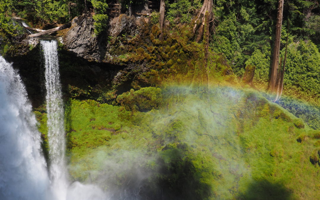
In about another half mile you come to the north Junction of the Waterfalls trail which is 4 miles from the trailhead. Be sure to walk down the trail and see both overlooks of Sahalie Falls before you cross the bridge. The waterfalls are amazing during the Spring runoff and we picked the first Overlook to have lunch, enjoying the thunder of the water as it crashes into a pool below the falls. After lunch we walked back to the north Junction of the Waterfalls Trail and crossed the MacKenzie River on a large glulam bridge.
From here the trail gets rockier and passes by some good views of Sahalie Falls and Koosah Falls. The trail then drops down by the river for a bit and it would be easy to get water here if you wanted some. Be aware that this area is the last water for about 5 miles. The trail then goes away from the river and continues through an old growth forest with a mix of big trees and huge trees. We paused several times to admire the huge old-growth trees along the trail.
Before long the trail goes above Carmen Reservoir and this is where the McKenzie River disappears. Some of the river is routed through an aqueduct tunnel to another Lake and the rest of the river goes underground through lava rocks and lava tubes until it flows out of the blue pool just below Tamolitch falls. The trail follows a dry riverbed in old growth forest with several bridges that cross the streambed as the trail meanders below cliffs in the valley bottom. After a couple of miles you reach the blue pool but this is not an easy place to get water as you have to bushwhack around high above the edge of the pool and then drop down about a hundred feet to the edge of the pool. The falls are normally dry and only reappear during extra-heavy stream flow. After admiring the beautiful blue pool, continue down the trail which is very rocky for a couple of miles. The really rocky trail changes to a rooty trail where the trail drops back down to the level of the river which also provided places to get water.
We had hiked a long way and wanted to rest our weary feet. We were surprised there were so few campsites along the river. We found a nice looking camping area but soon discovered that the crowds travelling to the blue pool used the area as an open bathroom. It was getting darker and we looked in vain for another camping area. We finally decided on a spot in the trees. The forest floor all along this section of the river is an old lava flow. It took some time to find a tent spot that didn’t put a rock in your back.
Day 2. We weren’t in any hurry the next morning and while we were having breakfast Larry showed us his no-see-um bites on his arms and legs that he got last night. He had little red dots all over him. We packed up and hit the trail around 9 a.m and by then we had already seen a couple of mountain bikers and several hikers. The trail soon crossed a nice little stream with a segmented bridge. Randee told us that he had done some exploring behind the camp earlier that morning and had seen this stream came from a spring which was not too far from camp. The trail continues along the river and as we headed toward the trailhead for Tamolitch Falls we met many more people going to see the blue pool. It was an easy walk to Forest Road 2672 – 655 and by the time we reached the parking area we had seen maybe 50 or more people heading towards the blue pool. Robert was hoping for a bathroom here but no such luck so we continued toward Trail Bridge Reservoir. Over the half mile the trail climbs away from the river and then drop down to Trail Bridge Campground. The trail passed by some silver pipes that Randee said where electrical but we couldn’t figure out what they were for. As we were walking along I noted that so far we haven’t needed any bug spray which was a pleasant surprise since the hike was so early in the season. Also being in the forest most the time we had not needed to put on sunscreen either.
At the reservoir several of us wanted to use the bathrooms and soon found out they were almost totally full with a big shitstack in each one. I was very happy I had dug a cathole in the woods near camp that morning. I’ve mostly converted from toilet paper to natural materials so that I don’t help little paper flowers to bloom in the woods.
The trail continues mostly along the river and occasionally you hear road noises. Several mountain bikes passed us and then there would be a time when we didn’t see anyone on the trail. Walk out of the old growth conifer forest and onto Forest Road 610, a gravel road. Head down the road for about .1 mile heading south, pass a gate, then leave the road to the east and south to go back along the river. We made it to Deer Creek about 11 and stopped at at Deer Creek Hot Springs which is about 15.5 miles from the trailhead. The hot spring is in a little grotto by the McKenzie River. We found out that the river had just dropped enough in the last week to allow the hot water to pool without the McKenzie mixing with the hot water. We spent about an hour at the spring then ate lunch up near the parking area.
From there we continued along the mostly level trail admiring the old growth trees and the forest landscape. We crossed the bridge over Frissell Creek about 17 miles from the trailhead and saw a raft put-in point at the campground across the river. We started thinking about a campsite and found a wonderful spot a couple of miles north of Belknap Lodge. Larry and I had excellent spots very close to the river and the rest camped back in the trees about 100 feet from the river. We had a nice fire ring and there was plenty of wood to make a nice campfire. We still didn’t have many bugs other than the no-see-ums that attacked Larry the previous night.
We had a leisurely dinner except for PJ who was squishing her food pouch to mix it when suddenly a bunch of it gushed out onto her pants and the ground. Luckily the hot mess missed any skin.
Randee told us about his bigfoot experiences and when we went to bed I felt a little creeped out for a while before I fell asleep to the sounds of the McKenzie rushing by.
The morning of our final day and we could hardly believe it was Monday already. We got started about 8:30 for the final stretch. This day seemed very much like the previous day walking through mix of old trees with really old trees. We got to Buck Bridge about 10 am and I filtered water at the boat ramp while the others used the pit toilet at the parking lot. From here you walk along a forest road over the river then take the trail on the right. From here there are plenty signs of civilization. The trail is closer to the highway and you walk by some cabins. There are still interesting things along the trail to see and nice views of the river. We watched several rafts drift by going a little faster than we could walk.
We had been lucky that the first two days had been cool because the heat was on for the final day. Near the end of the trail the road is not far off and after passing the McKenzie River ranger station, parts are just off the shoulder of the road.
The waterfall loop, the hot springs, Paradise Campground, and Clear Lake can be very busy on weekends. Watch out for bikers, as this often narrow trail is a popular mountain bike route. The McKenzie River Mountain Resort provides a shuttle ($25; 541-822-6272) to drop you off at your starting point.
Enjoy the photos!
Gallery Pics
Switchback Steve
Recent Comments