

Vicinity Location:
About 40 miles southeast of Portland, OR in the Mt. Hood National Forest.
Directions:
From Portland, drive Highway 26 East about 42 miles through the community of Sandy to Welches, OR. Pass the stoplight at Welches and drive about .9 mile. Turn right onto East Salmon River Road. It is right turn at the Subway store. Drive 4.9 miles to a pullout on the left, just before the bridge over the Salmon River.
Park here and look for the sign for Salmon River Trail on the left.
A Northwest Forest Park permit is required to park from May 15th to October 15th.
There are bathrooms at the trailhead during the summer season.
Trail:
Middle Salmon River Trail #742 with connections to Kinzel Lake Trail Trail #665, Linney Creek Trail #499.
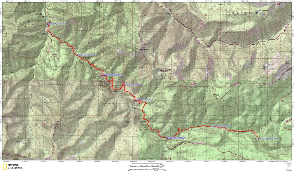
Trail Maps:
Topo Map, Download Garmin .gpx file
Length and Elevation:
Up to 26.2 miles round trip. Elevation at the trailhead is 1,720 feet. Highest point is at 3,100 feet. Lowest elevation is 1,720 feet.
One way elevation gain of 2,593 feet and loss of 1,352 feet to the turnaround. Total gain and loss is 7,900 feet.
Review: July 9, 2016
This trail can be done as an early season backpack trip when snows block the forest roads to the upper trailheads or a very long dayhike.
The trail gains about a hundred feet fairly steeply, generally levels out, then slowly drops back down to the level of the river over the next quarter mile. There are some wonderful views of the river as you walk along the riverbank on a rocky trail blasted out of the bedrock.
The trail roughly parallels the river for the first 1.5 miles gently rising and falling, passing quite a few campsites along the river. In sunny weather these campsites all fill up fast.
At 2 miles you reach the wilderness boundary for the Salmon Huckleberry Wilderness, Salmon River Trail #742. Here you need to fill out a Wilderness permit before continuing on your way. There are campsites scattered the first 2.3 miles. Leave the campsites and river behind and start slowly climbing up the hillside through a lush forest of cedar and hemlock trees along with ferns, Salal, Oregon Grape, Sheep Sorrell, and many other plants carpeting the forest floor.
Continue an unceasing climb up the hillside. After a bit you can no longer hear the river but only the sounds of the forest. At 3.4 miles to Junction for an unnamed trail the left. Continue straight ahead and come out onto an open hillside with views up and down the canyon. From this junction, climb up a couple of switchbacks to another unnamed junction at 3.7 miles from the trailhead. I suspect these two trail junctions are an abandoned route. Continue straight along the Salmon River Gorge.
At about 4.6 miles you will come out to another overlook where you have a view down into the Salmon River Valley and a glimpse of the river itself. The river noises now accompany you as you go along the undulating Trail as it slowly closes the gap between you and the river.
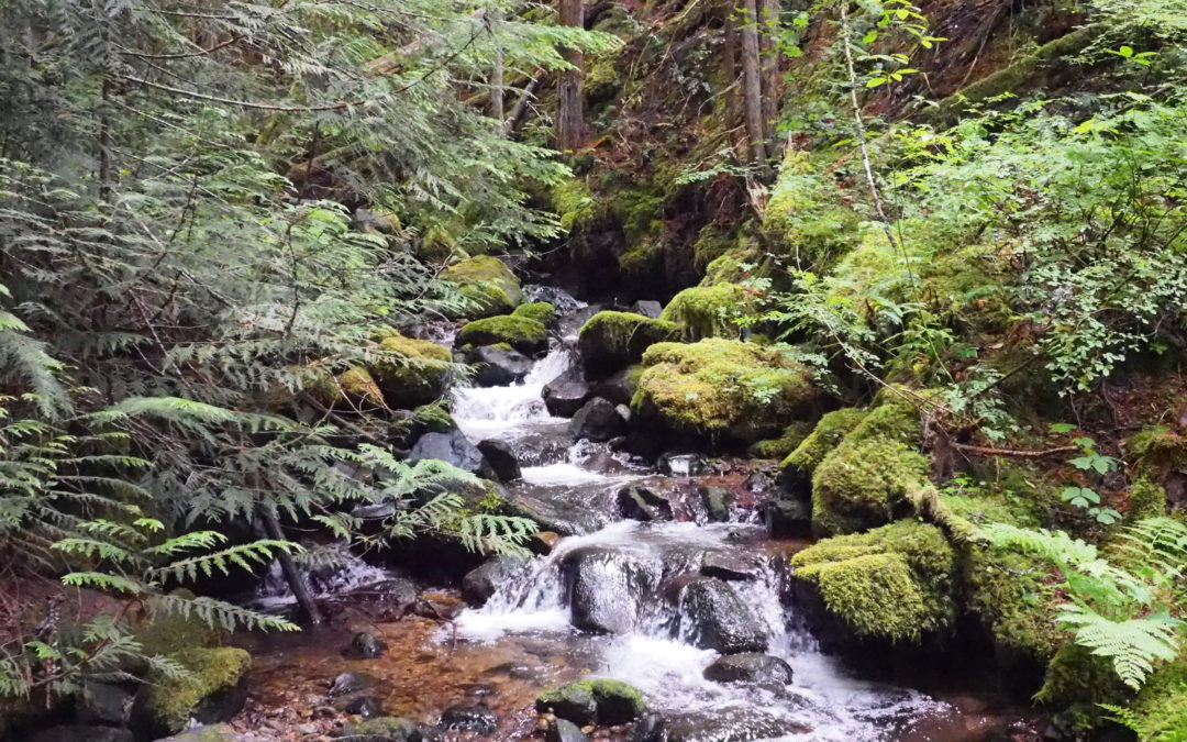
The trail slowly gets a little more overgrown as you go deeper and deeper into the Wilderness. You pass a couple more campsites, another nice little stream, and then at just over six miles you get to the junction of Kinzel Lake Trail Trail #665. If you’re thinking turning back here, walk just a bit farther to a lovely creek that crosses the trail. To make it a marathon hike, continue along the Salmon River. Along this section the trail you can barely hear the river in the distance though you are not far from the river.
Just at 9 miles you come to the junction for Linney Creek Trail #499 on the right. It is just a short walk down to where the bridge over Salmon River rotted long ago. If you want to cross the river, you might have to swim in this summer but if you’re staying at the campsite along the river, it looks like a nice swimming hole.
The trail continues through similar terrain for the next few miles as it crosses streams and passes views of the river. There are a couple of campsites around Wolf Creek but about .3 mile past Wolf Creek and about 10.5 miles from the trailhead is a nice large campsite by the river.
If you want to go further for the long day hike then continue about .5 mile past Fir Tree Creek which is around 13 miles from the trailhead and a good place to turn around and head back to the car.
Enjoy the photos!!
Gallery Pics
Switchback Steve
Recent Comments