
Notice: 9/24/2019 – Areas off-trail remain closed due to the Eagle Creek Fire. Starvation Ridge Cut-off trail #1414B is closed because of a slide on the trail. Starvation Ridge Trail 414 is still accessible by using the Mt. Defiance Trail #413 for both the out and return hike. This trail is managed by Oregon State Parks. Link to closure map.
Vicinity Location:
About 50 miles east of Portland, Oregon
Directions:
From Portland, Oregon, take I-84 east for about 50 miles, drive past the town of Cascade Locks, and take exit #55 – Starvation Creek Trailhead – Historic Columbia River Highway State Trail.
The exit leads right into the parking lot next to the freeway.
To return to Portland, continue east on the freeway for 1 mile and take exit 56 for Viento State Park. Turn left to drive under I-84 and turn left again to the westbound on-ramp for I-84 back to Portland.
From Hood River, Oregon, Turn Left to take ramp onto I-84 West towards Portland and drive about 12.7 miles to exit 51. Take exit #51 for Wyeth.
Make a U-turn by driving about .2 mile and turn left under the freeway on Wyeth Road then turn left onto the ramp for I-84 East. Drive back towards Hood River for 3.8 miles. Take exit #55 for the Starvation Creek Trailhead and the Historic Columbia River Highway State Trail.
The exit leads right into the parking lot next to the freeway.
To return to Portland, continue east on the freeway for 1 mile and take exit 56 for Viento State Park. Turn left to drive under I-84 and turn left again to the westbound on-ramp for I-84 back to Portland.
No permits are required to park at the trailhead.
Restroom facilities and drinking water are available at the trailhead.
Length and Elevation:
19.0 miles roundtrip. Trailhead elevation: 115 feet.
Starvation Ridge Trail – Long and steep. Elevation: 3,920 feet gain, 100 feet loss. Highest point 3,820 feet. Mt. Defiance Trail from Mitchell Point Trail 1,210 feet gain, 90 feet loss to summit.
Mt. Defiance Trail descent – Longer and steep. 4,900 feet of elevation loss, 50 feet of elevation gain.
Total loop – 5,150 feet gain and 5,150 feet loss.
Trail:
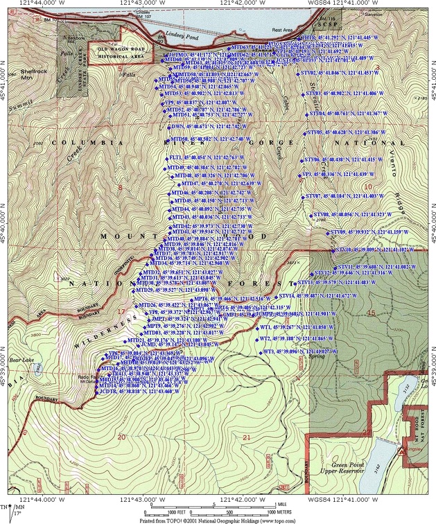
Starvation Ridge Cutoff Trail #414B, Starvation Ridge Trail #414, Mitchell Point Trail, Mt. Defiance Trail #413, Mt. Defiance Cutoff Trail #413B, with connections to the Historic Columbia River Highway State Trail, Warren Lake Trail #417A, and Bear Lake Trail #413.
There is at least one geocache for this trail at: N 45° 38.865 W 121° 43.405 Info at Geocaching.com
Trail Maps:
Topo Map, Download Garmin .gpx file
Review: October 20, 2010, April 14, 2012
The trailhead is at the west end of the parking area and goes west. The trail adjoins the shoulder of the freeway for about .2 mile. At .25 mile west of the trailhead is the trail for Starvation Ridge Cutoff Trail #414B. The trail goes sharply to the left and steeply uphill. Take this left and begin the long climb away from the noisy highway up Starvation Ridge. The trail is well maintained and the basalt rock base provides good traction in wet weather.
The trail climbs quickly up to a slight viewpoint of the Gorge, then steeply switchbacks up the end of Starvation Ridge through the forest about .6 mile to the junction of Starvation Ridge Trail #414. Turn left and continue up the Starvation Ridge Trail. The trail is in a Douglas Fir forest mixes with maples and Vine Maples. The ground cover mainly consists of Sword Fern, Oregon Grape, and mosses. The terrain here is rocky with a thin layer of topsoil and the drier climate helps to keep the underbrush sparse. Coming up the trail you hear Cabin Creek but the sound of the stream quickly fades as the trail makes for the ridge.
The trail soon climbs to a very nice overlook at the edge of the ridge at the top of steep cliffs. A trip here would be fatal.
About .25 mile after the viewpoint the trail comes into an area cleared for the overhead powerlines. Continue steeply switchbacking up the west side of Starvation Ridge climbing beneath powerlines. After reaching the crest of the ridge, walk out to the jutting ridge. From here there are great views to the east and west. Continue back under the powerlines and head directly up the spine of Starvation Ridge.
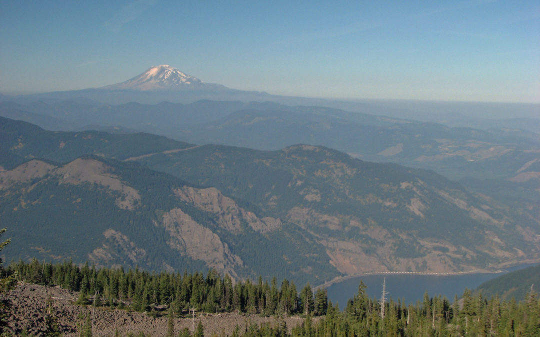
After climbing uphill for about a mile, the ridge flattens out for about .2 mile before resuming the upward struggle to the top. Climbing relentlessly to the 2 mile point, along the ridge towards Warren Lake. Waypoint VP2 gives an excellent view looking west to North Bonnevile, the Columbia River, and beyond. At about 2.25 miles the trail moves to the east side of Starvation Ridge the trail starts switchbacking up the edge of an old talus field providing views of the Viento Ridge to the east and out into the Gorge. There are a couple of places along the trail where you can see Mt. Adams clearly through breaks in the trees.
It is a long 3 miles to where the trail finally starts dropping down to Warren Lake. It is uphill almost all the way with a gain of almost 3,800 feet from the trailhead. No the trail gently goes downhill to the junction to Warren Lake. You can see into the Gorge through the trees from the ridge top.
Walk along the needle-covered trail for about .5 mile to Waypoint JCMPT which is the junction of Warren Lake Trailhead #417A and Mitchell Point Trail. Going to the left leads to Forest Road 2821 in .25 mile.
Just before Warren Lake is a campsite on the left. There is a trail that goes from the campsite to the east shore of Warren Lake. Right next to the lake is a small flat area where you can sit and enjoy the lake. From the campsite the trail continues down to Warren Lake. You can see that the lake is shallow most all the way across.
The trail goes along Warren Lake for a short distance, then goes off into the woods uphill to the right. Follow the trail through the woods to where it crosses through a small boulder field, climbing about 20 feet, then reentering the woods. As the trail heads straight up the hill into the woods, look back and catch a list view of Warren Lake.
The trail soon crosses a small talus slope and swithbacks up the slope and back into the woods. This section of the trail is less used than other trails and is sketchy at times. The trail will be very difficult to find whenever there is more than 6 inches of snowcover. You will need a GPS with waypoints or excellent map and compass skills whenever there is a snowpack present.
Waypoint JMPT is the junction of the Mitchell Point Trail and the Mt. Defiance Trail. Take a left at this junction and continue uphill towards Mt. Defiance. At waypoint JCMD there are two small rock cairns marking this trail junction. The right fork of this trail is the return trail from Mt. Defiance. Continue straight ahead at this junction and go up the trail. After more uphill walking on the rocky trail, cross a jeep road, looking across and a little to the right for where the trail continues back into the woods. The trail comes out to the jeep trail farther up the hill and look across the road and uphill and you’ll see where the trail reenters the woods. You are so close that if there are any people working on the towers you’ll be able to hear their voices.
The Mt. Defiance Trail comes out by where the north guyline from one of the towers is anchored. There is a faded sign on a tree marking the trail. From the antenna field, take a small waytrail to the west that leads to some boulders. Climbing to the top of the rocks gives views of Mt. St. Helens and Mt. Rainier. The trees are slowly encroaching on the views as the years go by.
At Waypoint MDLP, head downhill from Mt. Defiance. This waypoint is on the south side of Mt. Defiance and the trail was not signed at the time of this review. The trail begins to curve to the right as it heads downhill. Pass a false junction in the talus and in about .2 mile there is a junction for Beak Lake on the talus field, turn right at the broken-down sign and continue on a general contour of Mt. Defiance across the talus and rock fields. This part of the trail has spectacular views of Mt. Hood. The trail continues to flank Mt. Defiance and heads towards the Columbia River Gorge. A short distance farther continues across the talus slope and the green waters of Bear Lake come into view far below.
The trail briefly enters the trees and continues pass junipers and other tough alpine plants growing among the rocks. After Bear Lake there is a great view of Mt. St. Helens and Mt. Rainier in the distance. Looking down you can see the dome of Wind Mountain far below on the Washington side of the Gorge.
The trail passes another viewpoint of Mt. Adams, Rainier, and St. Helens before reentering the woods. Continuing along the trail there will be an opening along the left, marked as VP7. it leads to an incredible 180 degree panorama of the Gorge and the mountains to the north as well as the Columbia River and the town of White Salmon. Stop awhile to admire the view, then continue towards the Mt. Defiance Trail junction.
About .2 mile after the viewpoint is the junction with the two small rock cairns. Turn left and head down the Mt. Defiance Trail and in about .3 mile is the junction for the Mitchell Point Trail towards Warren Lake. It is marked by a fairly large stone cairn and faded trail sign. Help a little with the trail and add a stone to the cairn as you walk by. Continue straight ahead along the Mt. Defiance Trail to another nice viewpoint opening to the north and east. There are a few cairns along this section of trail. This trail winds along a rocky slope and will disappear quickly under just a few inches of snow.
As the Mt. Defiance trail drops rapidly it becomes less rocky in sections and is softly covered under a layer of fir and hemlock needles, passing from the Mark Hatfield Wilderness into the Mt. Hood National Forest. The walk is pleasant and the forest is fairly open along this section of trail and going downhill makes the walking easier.
The alternates between forest duff and rocks for the next couple of miles and finally reaches a flat spot at about the 2,300 foot elevation to provide your feet some for your feet. This mostly level section lasts about .3 mile before dropping off the ridge. Waypoint FLT1 marks the flat area and a grove of beautiful Vine Maple which forms a canopy over your head and it is especially nice in the fall when the leaves are just turning yellow.
Soon the trail descends countless switchbacks, passes a viewpoint of Wind Mountain and the Columbia River, and continues down the switchbacks.
After walking along the powerlines for about .3 mile, the trail passes Wonder Creek and Lancaster Falls which cascades over the rocks. This point is less than a mile from the trailhead and the elevation is about 250 feet and only about 100 feet of elevation to lose before returning to the trailhead.
Just after the waterfall is JCSTA, the junction for the Starvation Ridge Trail. Continue towards the trailhead because you don’t want to walk this trail twice in one day.
Soon the trail comes to Hole-in-the-wall falls and crosses the stream over a nice wood bridge. The highway sounds are pretty loud here and at last you come to tiny Cabin Creek Falls. It is barely noticeable next to a giant basalt plug along the freeway.
Enjoy the photos!
Gallery Pics
Switchback Steve
Recent Comments