
Vicinity Location: The trailhead is about 30 miles east of Portland, Oregon in the Columbia Gorge National Scenic Area.
Directions: From Portland take I-84 east for about 30 miles. Follow the signs for Multnomah Falls and take exit 31, which is a left exit, off I-84 to the parking area. Follow the paved path under the highway and railroad tracks to reach the falls viewing area. All nearby parking areas fill up every summer weekend and many other times during the year.
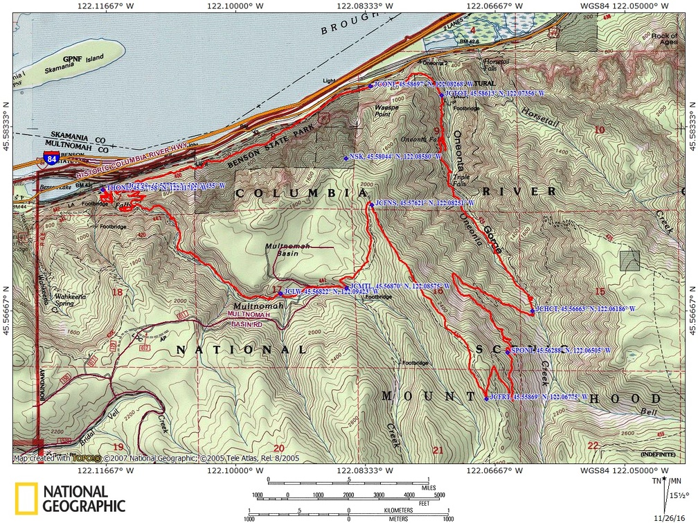
Trail Maps: Topo Map, Download Garmin .gpx file
Length and Elevation:
12.4 miles roundtrip. Elevation at the trailhead is 125 feet. Total gain is 3,600 feet and loss is 3,600 feet. Highest elevation is 2,800 feet and the lowest elevation is 125 feet.
Review: 11/3/2016
Multnomah Falls is the second most visited tourist attraction in Oregon. From the Multnomah Lodge walk up past the throngs of people to the main viewing area. The two falls make a 611-foot-tall roaring, awe-inspiring cascade of white water. Continue up the paved path and cross the scenic arched Benson Bridge over Multnomah Creek. Many times you’ll walk through the mist from Multnomah Falls as it crashes onto the rocks at the base of the upper falls. After the crossing Benson Bridge, go up the paved trail to the beginning of the second switchback, turn left to follow Gorge Trail #400 east. This next part of the trail is pretty level, near the freeway, and you hear the constant noise of traffic and passing freight trains.
Most of the Gorge Trail is in good shape though part of it has a steep outslope which can make it a little slippery when there are leaves or ice on a trail. There are a couple of rockfalls along the trail but they are not large or difficult to cross. After about 1.5 miles, drop down to cross a small creek then down to the highway and walk across a small parking area and start climbing back up on Trail #400 again. You soon join the Oneonta Trail and continue uphill from the junction.
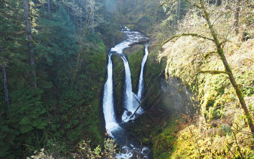
The trail narrows as it switchbacks up a steep hillside above the creek. There is a short, steep, reroute over a landslide and after traveling about 3.7 miles from the trailhead you reach Triple Falls. There are three distinct streams of almost equal size plunging over a cliff when the fall rains swell the stream.
Soon after passing Triple Falls, cross a log bridge over the creek then follow the torrent for another mile or two enjoying the sights and sounds of the water rushing down to the Columbia River. In about 4.7 miles there is a small section where the trail is washed out. During times of high water getting by this washout may be very difficult to navigate.
The forest floor is fairly open and there’s quite a variety of plants growing on the forest floor. Ferns, apple Clover and thimbleberry carpet the forest floor. This is still the wet part of the Gorge so the rocks along the trail are covered in a green carpet of moss. Just a short time after the washout you come to the next crossing of Oneonta creek and walk up the trail about 500 feet and to the junction for Horsetail Creek Trail and the Oneonta trail. Go straight and continue on the Oneonta Trail to the junction with the Franklin Ridge Trail which is another 1.7 miles.
Continue to climb for what seems a long 1.7 miles, passing a small spring that is right next to the trail. Sometimes the trail goes up very steeply and sometimes very gently on switchbacks to the top of Franklin Ridge. The top of the ridge is the high point of the trail at 7.75 miles with a gain 3,300 feet and a descent of 700 feet. Continue over the top of the ridge for about 200 feet to the junction for Franklin Ridge Trail. Turn right and continue through the pleasant second growth open forested slopes as you begin to lose elevation as you walk along the ridge.
Continue down along Franklin Ridge Trail through a lovely open Forest where there’s one nice view of Mount Adams on the right. There are some views through the trees of the neighboring ridges to the south through the forest. After walking for a mile or so, you’ll come to a tiny little junction on the right with a user trail that leads to Nesika Lodge. Continue down the Franklin Ridge Trail to the junction with the Oneonta Trail.
Turn right at Multnomah Creek and follow the creek as it rushes over rocks and logs. Walk across a dirt road that runs through Multnomah Basin and follow the path on the other side of the road, continuing downstream. Pass an unmarked junction for the Highwater Trail. This is an alternate trail for when the stream floods the next section of the trail and rejoins the Oneonta Trail in about 500 feet. Continuing downstream you’ll cross on a wood decked steel bridge. Sections of the trail have been blasted out of the cliffs above the creek and pass by some nice waterfalls. There is an especially nice view as the trail switchbacks and heads upstream towards the waterfall. Soon the trail crosses back over to the east side of Multnomah Creek. From the bridge, walk uphill a bit to the junction to the overlook and walk out to the platform that looks out over the top of Multnomah Falls. Enjoy the great view out into the Gorge and the dizzying plunge of the water going over the falls. Head back up following to where the trail crosses over the lip of the Gorge then follow the switchbacks down to the Benson Bridge. From there stroll back down to the lodge where you can have a beer or other refreshments and use the bathrooms.
This is an especially nice hike during the fall rainy season when rainfall creates cascades of water everywhere. This trail also has quite a few mushrooms that appear in the fall.
Enjoy the photos!!
Gallery Pics
Switchback Steve
Recent Comments