

Vicinity: About 10 miles southeast of Portland.
Directions:
From Portland, take I-84 east to I-205 south. Take exit 19 for Division Street and turn left at the traffic light (you can’t turn left on Powell). Take SE Division to SE 136th Ave and turn right.
Turn left onto SE Powell Blvd and drive for about 1.5 miles and turn right onto SE 162nd Ave. This will lead you into the main parking lot.
TriMet serves the park on the #9 bus route.
The park gates open at 7 a.m. and close 6 p.m. In winter, 8 p.m. spring and fall, and 10 p.m. in the summer.
There are bathrooms at the trailhead.
No permits are needed to park but the parking lots fill early on weekends and sunny weekdays. Expect the parking lot to be full most of the day. There are alternate trails that lead into the park with street parking available.
History:
Powell Butte is an ancient lava dome and is part of the Boring – East Buttes Lava Domes. It was a mix of forests, pastures, and an orchard until the City of Portland purchased 603 acres in 1925. In the southeast corner of the park on the Cedar Grove Trail is a Douglas fir heritage tree that is over 300 years old.
Length and Elevation:
4.5 miles. Elevation at the trailhead is 460 feet. Lowest point is 311 feet. Highest elevation is 615 feet. Total ascent is 480 feet and total descent is 480 feet.
Trail:
Mountain View Trail, Summit. Lane Trail, South Trail, Hawthorn Trail, Meadowland Lane Trail, Forest Edge Trail, Pipeline Lane Trail with connections to Springwater Corridor Trail and various others.
There is at least one geocache for this trail at: N 45° 29.137 W 122° 29.979 Info at Geocaching.com
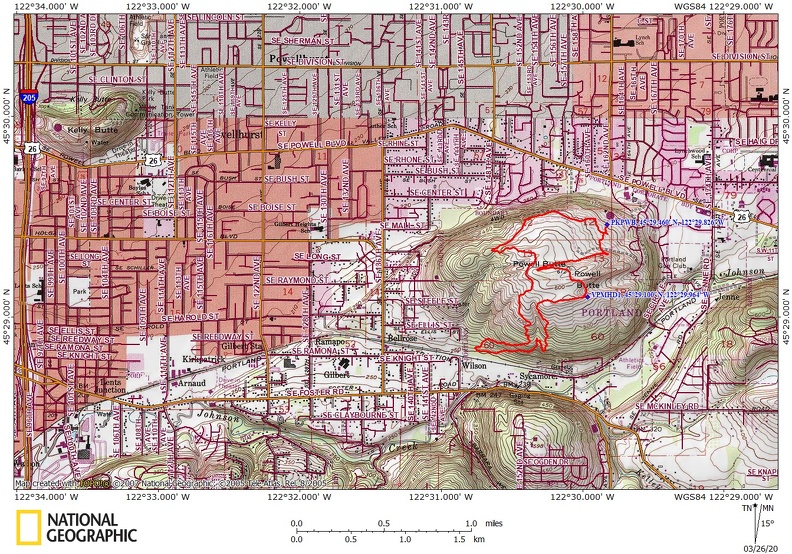
Trail Maps:
Topo Map, Download Garmin .gpx file, Open Garmin .gpx file
Review: February 19th, 2020
The official name of this park is Powell Butte Nature Park. From the parking lot and visitor center head generally east and uphill to take one of the main trails that switchbacks up to a panoramic viewpoint. Most of the trails are paved and others are well gravelled. There are multiple trails in the park and you take the different trails to make about as long of a walk as you would like. This park adjoins the Springwater Trail which runs from downtown Portland to Boring, Oregon.
The Powell Butte Nature Park has a large area that is fairly open with a mixture of Douglas fir trees and Oregon white oak.
Continue up the Mountain View Trail to the viewpoint. There are many signposts in the park with cut-out stencil trail names and small vicinity maps with directions back to the visitor center and other trails.
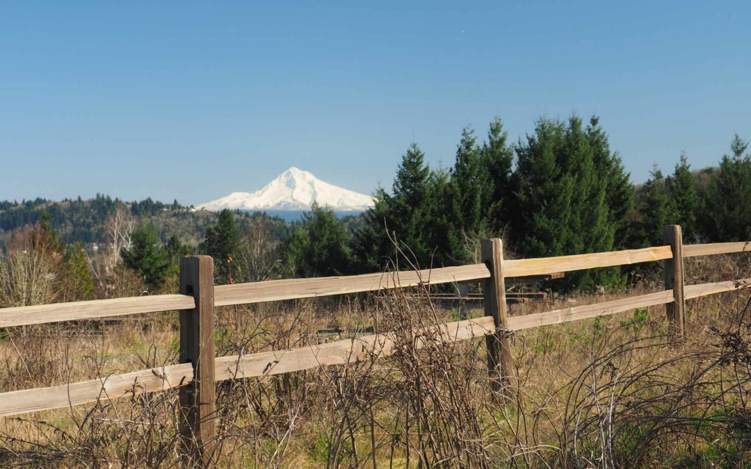
After the Summit View Trail turn onto the Summit Lane Trail. The trail begins to gently descend past lovely views of Mt. Hood to the east and Mt. Adams to the north.
At about 1.3 miles, turn left onto the South Trail at Junction 17. This will take you down into the woods, wind around, then come back up to the Summit View Trail.
You’ll travel down through a forest of Douglas fir with cedars mixed in and cross a small stream flowing down the hillside.
The next junction you come to is the Cedar Grove Trail and the link to the Springwater Corridor. Continue right so that you take the Hawthorne Trail up through the forest.
When the trail begins to flatten out and curve to the left there is some lemon balm mixed in with stinging nettle. If you don’t know what stinging nettle is then take a look at the photos so you don’t brush up against stinging nettle.
Climb up out of the trees through the meadow to junction 16 which is the end of the Hawthorne Trail. Turn left here and continue on the Summit View Trail which leads over a small ridge and back down to the parking lot.
At the top of the ridge you will reach junction 14 where you continue straight ahead on the Meadowland Lane Trail.
At junction 40 you can add a forested loop by taking Forest Edge Loop Trail on the left. This winds through a nice forest then rejoins the Meadowland Lane Trail then the Pipeline Lane Trail to the parking lot.
Enjoy the photos!!
Gallery Pics
Switchback Steve
Recent Comments