

Vicinity Location:
The trailhead is about 40 miles southeast of Portland, OR.
Directions:
From Portland drive east on Hwy 26 to Zigzag and turn right onto East Salmon River Road. Follow the paved road for 5 miles to the bridge over Salmon River. Watch for potholes at the end of the bridge and most of the way along the 1.7 miles of gravel road to the parking area. The parking area is a small pull-off on the left side of the road. Look for the sign for trail 791 on the right.
A Northwest Forest Pass is required to park at the trailhead.
Portable outhouses are available seasonally at the bridge over Salmon River about .5 mile from the trailhead.
Dogs on leashes are allowed on these trails.
Length and Elevation:
Salmon Butte Trail #791 is 8.8 miles roundtrip. Elevation gain of 2,745 feet and loss of 1,963 feet to the summit. Total elevation gain is 4,600 feet and loss of 4,600 feet. Trailhead elevation: 1,980 feet. High point on trail: 4,877 feet.
Trail:
Salmon Butte Trail #791
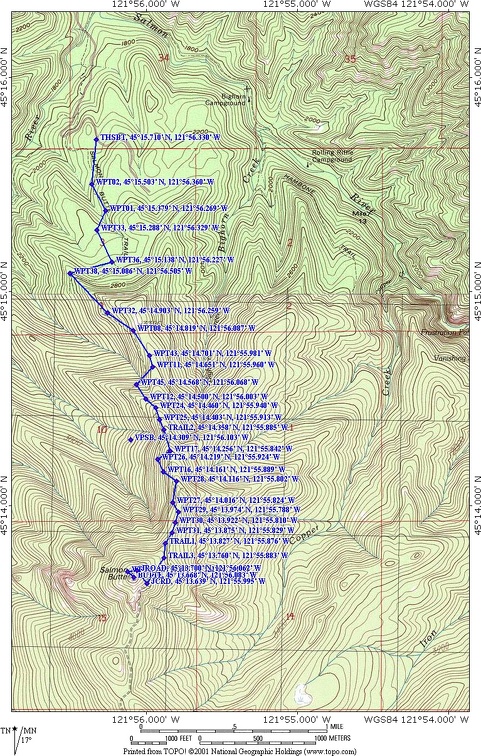
Trail Maps:
Topo Map, Forest Service Map, Download Garmin .gpx file
History:
A Forest Service fire lookout was at the top of this butte. It was demolished in the 1960s by the Forest Service. Only fused glass, old nails, rusty hinges, and a few boards remain.
Review: June 27, 2009
The trail begins on the gentle grade of an old road and soon passes an area off to the right that used to be the trailhead parking area. Soon the grade changes to a moderate steepness and this same rate of gain is maintained through most of the hike. Much of the Salmon Butte hike is among 100 foot tall second growth trees.
The trail is well maintained, passing through the fairly dense forest and past rhododendron bushes and into the Salmon-Huckleberry Wilderness. After about two miles, there is a short side-trail that leads to an old landslide. Most of the soil has been stripped away but what is left supports a wildflower meadow on the steep slopes of Salmon Butte. There is a nice view of the surrounding forests but take some caution to keep your footing and not slide down the damp slopes.
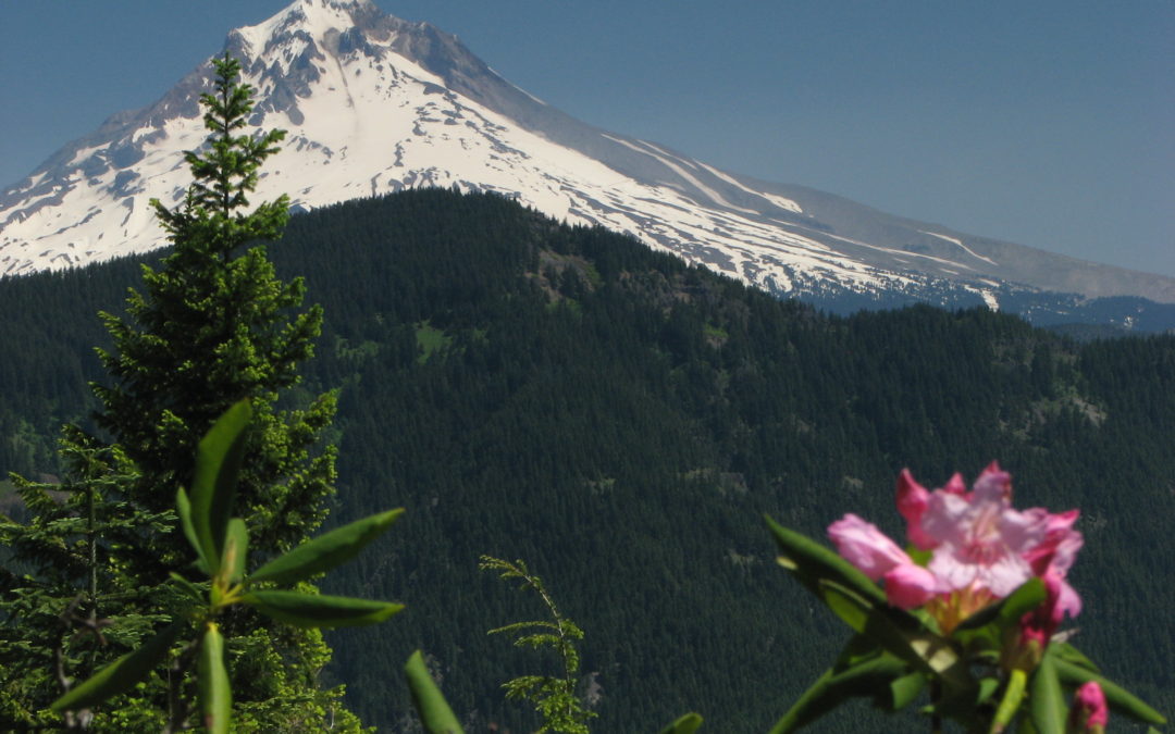
The trail climbs switchbacks and goes over a ridge to the eastern side of the butte. On this side of the ridge are some clearings and the rhododendrons grow profusely along a short section of the trail. In the late spring their blooms burst out above dark-green leaves and Mt. Hood provides a snowy backdrop to the northeast from some of the clearings along the trail.
The trail continues to climb through the forest up to an old forest road. The old road to the left does not lead to views of Mt. Hood so take the trail to the right, following the old road. Now the trail begins a spiral around Salmon Butte, coming out of the trees to spectacular views of the surrounding forest and several cascade peaks of Mt. Hood, Mt. Jefferson, and on really clear days, Mt. Adams in Washington and the Three Sisters to the south.
Just a short walk up to the top of the butte and you will find remains of an old fire lookout which was burned down instead of dismantled. Nails, pieces of metal, and fused glass litter the ground at the top of Salmon Butte but the views are well worth the trip.
From the top are great views in all directions. There are some steep side slopes along parts of the trail, but with reasonable care, this trail is safe for small children and pets. The most dangerous spot is the small landslide made clearing just off the trail, about 3 miles from the trailhead.
Enjoy the photos!!
Gallery Pics
Switchback Steve
Recent Comments