

8/15/2021 – Notice: The trail is open but be alert for downed trees, hanging limbs, debris, and trail damage caused by the Labor Day windstorm and winter ice storm. Access roads are limited due to the Riverside Fire of 2020 and require navigation and backcountry skills. Check Riverside Fire damage for closures.
Vicinity Location:
The trailhead is about 42 miles southeast of Portland, Oregon in the Roaring River Wilderness.
Directions:
From Portland, drive on Hwy 224 to Estacada. Go about 25 miles past Estacada on Hwy 224 to the Ripplebrook Ranger Station on the left side of the road. About 100 feet after the ranger station turn left on FR4631. Drive 2.4 miles and keeping right at the fork and continue on FR4630 for 0.6 mile. The pavement ends in about 0.4 mile.
Turn left onto FR4635 and drive 7.5 miles Turn right at the fork for FR140, drive 1.8 miles and park in a small pullout on the left which is just before the culvert for Cripple Creek. Most of these roads are unmarked and Google Maps does not know this trailhead.
There are no permits needed to park at this trailhead.
No bathrooms available at or near the trailhead.
Length and Elevation:
Distance 11.2 miles, Elevation gain is 2,280 feet and loss is 2,280 feet. Lowest point on the trail is 4,061 feet and the highest point is 5,015 feet.
Trail:
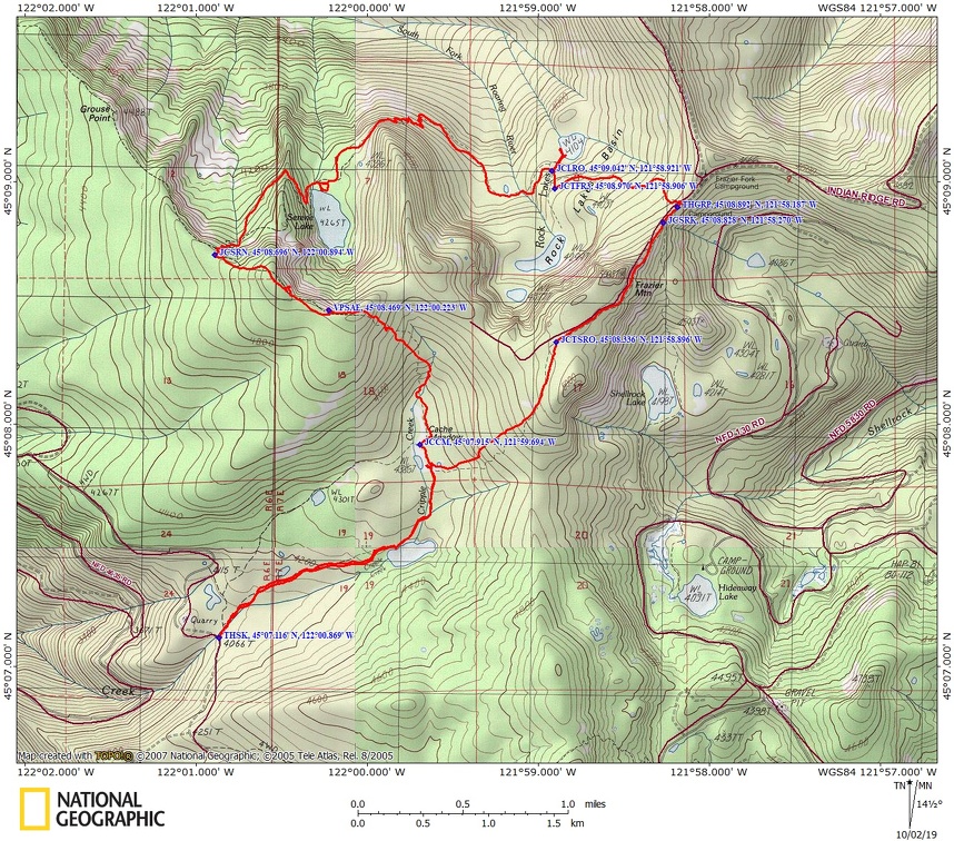
Cache Meadow Trail #702, Grouse Point Trail #517, Serene Lake Trail #512 with connections to Shell Rock Lakes Trail #700
There is at least one geocache for this trail at: N 45° 08.696 W 122° 00.836 Info at Geocaching.com.
Trail Maps:
Topo Map, Download Garmin .gpx file
Review: August 22, 2019
Once you find the brushy trail, head about 50 yards upstream to a junction and take the fork to the right which generally parallels Cripple Creek.
After about 1.5 miles you come to a Cripple Creek Lake which is a shallow little lake. There are a couple of lakeside campsites. This part of the trail is nicely forested with hemlocks and silver firs. The understory here has huckleberries which ripen in late August.
About 0.3 mile you get to Cache Meadow. Early summer you may have to guess where the trail goes. Cross the boggy area and head into the brush. You should find the large campsite at Cache Meadow in about 75 feet. The trail on the right is the one you will use on your return. Go left out of the campsite, walk about 600 feet to where there is a left and right trail junction and make a sharp right. Do not go straight and use Cache Meadow Trail #702.
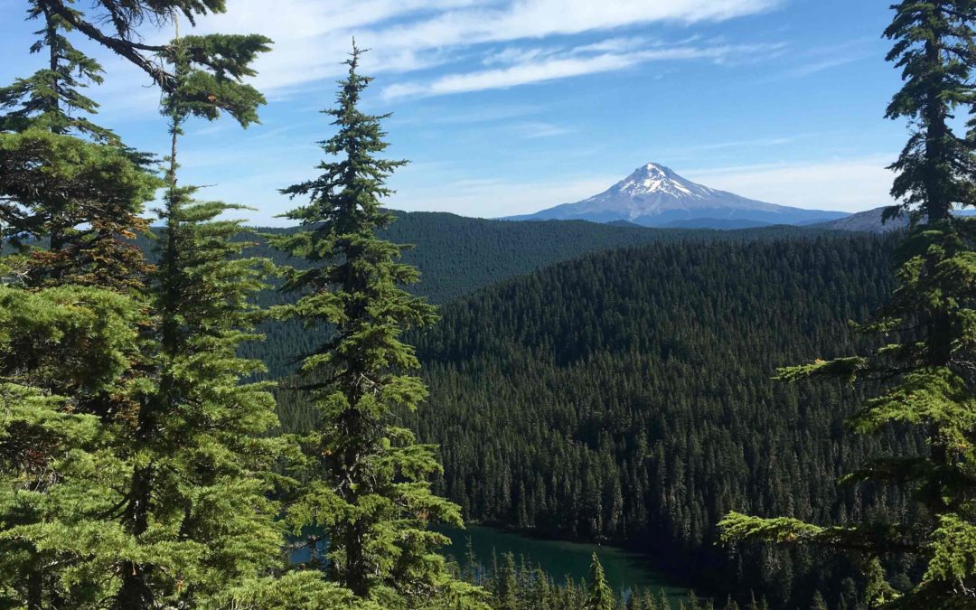
Climb fairly steeply for about 2.5 miles. This leads to a lovely viewpoint at about 2.7 miles on Grouse Vista. From this point you have a four mountain view, Mt. St. Helens, Mt. Rainier, Mt. Adams, and Mt. Hood. You can see the blue waters of Serene Lake below and Mt. Hood in the distance. Although there is a fire ring here, there is no nearby water. In about 0.25 mile is a user trail that leads to a rocky cliff that has another nice view of Serene Lake with Mt. Hood in the background.
From this point the trail begins to drop fairly rapidly for about 0.8 mile to the trail junction that leads to Serene Lake. Turn right at the junction then descend some switchbacks to the northwestern shore of Serene Lake and a few large campsites.
This is a very swimmable lake and down the lakeshore to the right about a few hundred feet is a large boulder that you can jump off of into the lake.
Continuing around the lake are some user trails leading to a few small campsites and more places to swim.
About 0.5 mile past the lake the trail traverses a steep hillside above the Roaring River which you can hear in the distance. The forest here is a somewhat open forest of hemlocks and silver firs. Over the next 1.5 miles, descend several switchbacks, then regain about 150 feet of elevation the walk through the floor of a small flat area where the forest floor becomes wetter and the tree mix changes to cedars and silver firs with salmon berries along the trail. Cross a tiny stream in the wettest area then on through the forest begin to climb again. As you climb out of the valley, the cedars disappear and the forest turns back into a mix of hemlock and silver firs.
Take the short spur trail on the left down to Lower Rock Lake. It is a pretty little lake with a nice campsite near the shore. On a sunny day you may be able to sit at the edge of the lake and see the salamanders swim by.
Climb up from Lower Rock Lake to a junction for Frazier Campground. Turn left and steadily climb up to Frazier Campground which is about 0.8 mile uphill from the junction of Lower Rock Lake and is the Serene Lake Trailhead, Trail #512. Turn right and walk about 100 feet to the Grouse Point Trail #517 back towards Cache Meadow.
In about 0.2 mile is the junction to Shellrock Lake. Continue up the abandoned forest road, passing through rocky slopes with quick views of Mt. Jefferson. Enter back into the trees and after cresting Frazier Mountain descend for about 0.1 then turn left and leave the road.
Descend fairly steeply down the trail that is rocky at times back to Cache Meadow. Once at the campsite, remember to turn left to head back to Cripple Creek Lake.
Enjoy the photos!!
Gallery Pics
Switchback Steve
Recent Comments