

Vicinity Location:
About 69 miles east of Portland, OR in the Columbia River Gorge.
Directions:
From Portland: Drive east on I-84 for about 80 miles, driving past Hood River, to exit 82.
Take exit 82 and drive about 0.2 mile along the off ramp and turn right at the stop sign.
Drive a short 400 feet on River Road to the next stop sign and turn left onto Highway 30 and drive 0.3 mile to Chenoweth Road and turn right.
Drive 0.4 mile on Chenoweth Road and turn right onto Sevenmile Hill Road and drive 1 mile to a dirt road on the right. Turn onto the unsigned road and drive about 0.25 mile up to a small dirt parking lot bulldozed into the hillside.
Notice: At the time of this review, Google Maps is not correct and directs you too far on Sevenmile Hill Road.
There are no restrooms. The closest restroom is probably Home Depot in The Dalles.
No permits are needed to park here.
Length and Elevation:
4.7 miles roundtrip. Elevation at the trailhead is 720 feet. Total gain is 1,540 feet and loss is 1,540 feet. Highest elevation is 2,060 feet and the lowest elevation 720 feet.
Trail:
Sevenmile Hill Trail (Unofficial Trail)
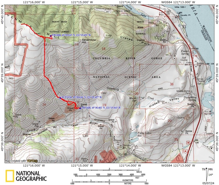
Trail Maps:
Topo Map, Download Garmin .gpx file, Open Garmin .gpx file
Review: May 3, 2024
From the parking area don’t go past the no trespassing barrels, but follow the bulldozer track up the hill. Soon the old jeep trail starts to turn to the right and continue fairly deeply uphill.
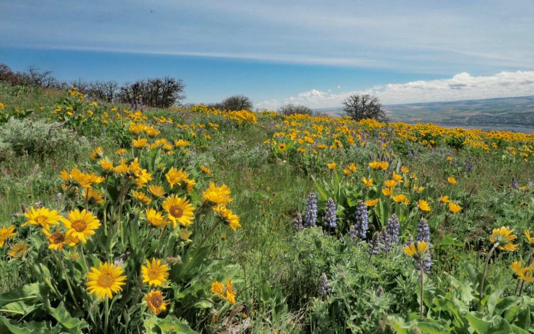
Where the jeep trail loops around to the left up the hillside look for the path going uphill. You’ll climb up and up and soon be into wildflowers and poison oak. The views just get better and better and the poison oak less and less.
Pass-through a boulder field left by the Missoula Floods then continue west along the left side of a little valley.
The route is fairly steep, but you are rewarded with hills carpeted with Balsamroot and Lupine as you climb higher and higher.
After walking uphill for a half a mile, you’ll come to another trail that joins that comes from below. Continue up the hill and you’ll pass a place where people are stacking rocks for a windbreak or something. Turn a little to the right here and walk up the next hill.
Continue your relentless climb until you reach a fence line. This is a private boundary property. Turn right and follow the fence line north towards the summit of Sevenmile Hill.
Your wanderings will eventually lead you to a grove of oak trees. You should be able to pick your way through here amidst little sprouts of poison oak and then after 500 feet you’ll turn left and work your way through the brush up to an old farming road that is on public property.
Once on the road, you can walk up over the top of Sevenmile Hill, which is more of a gentle rise than a hill, and then continue walking for another quarter mile till you reach cultivated fields. This looked like a good place to turn around though you could walk quite a but further and minding property lines, all the way to Tom McCall Point.
Heading back, you can see a definite path through the woods that leads down to the open meadows. Once you walk in the meadow a bit, you can climb up heading north and top the ridge and you look into the Columbia River Gorge.
To return, head south and skirt the little Grove of trees until you find the cow path and follow it uphill through the oak forest. In a short way, you’ll find the faint trail branches where you take the left branch to return to the path that you hiked along the fence line.
Follow your path along the fence line then head back downhill to where you come to a little rise then to the Trail junction. Turn right here, which is the more defined track and get a little variety though this route goes just above the quarry and isn’t as scenic.
Follow the track as it skirts the upper part of the county rock quarry and find a path back to the parking lot.
Enjoy the photos!!
Gallery Pics
Switchback Steve
Recent Comments