

Notice: 1/15/2021: This trail is closed due to wildfires in the summer of 2020.
Vicinity Location: The trailhead is about 76 miles southeast of Portland, Oregon in the Willamette National Forest.
Directions:
From Portland, take I-5 south for about 46 miles, driving through Salem.
Take exit 253 for OR-22 E toward Detroit Lake/Bend and drive 0.3 mile to the traffic light, choosing one of the left lanes.
Turn left onto OR-22 E/Mission St SE, crossing over I-5 and continue to follow OR-22 E for 65 miles.
Turn left onto Marion Creek Rd. The road is just before Marion Creek and is easy to miss. It is 4.5 miles from Hwy 22 to the trailhead. The road is not plowed. Drive to where you will be able to get back out if it snows during the trip, and park.
A Northwest Forest Pass may be required. There is no fee during winter.
There is an outhouse at the trailhead.
You can see avalanche forecasts here: Northwest Avalanche Center
National Weather Service Snow Level forecast: Northern Oregon Cascades
Length and Elevation:
12.6 miles round trip. From the trailhead to camp is 6.3 miles and an elevation gain of 3,000 feet with an elevation loss of 100 feet.
Trail:
Marion Lake Trail #3436, Lake of the Woods Trail #3493, with connection to the PCT trail #2000.
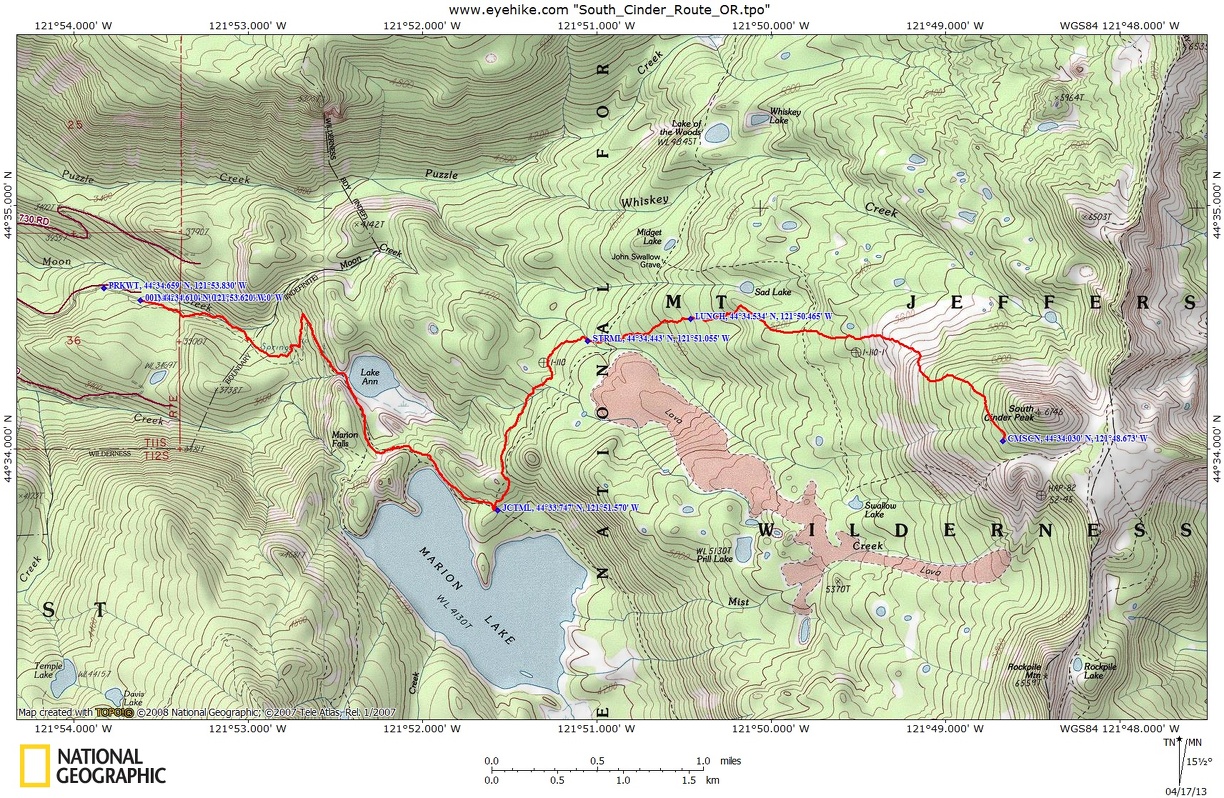
Trail Maps: Topo Map, Download Garmin .gpx file
Review: April 13, 2013
The four of us drove up the road until the snow prevented us from going any farther. Since it was dark, we decided to walk up to the trailhead and set up our tents. We walked less than .25 mile and reached the trailhead. Some of us camped on snow and some on wet forest duff.
I hadn’t brought a tent and Jerimiah offered me a spot in his tent, which I gladly accepted. The sleet turned to snow and we were snug in our bags until Jerimiah heard a noise and shined his flashlight onto a rat. It must spend its nights looking for camper’s food. We didn’t have any food in the tent or in our backpacks, but Jerimiah finally pulled his backpack into the tent to get it away from the rat. The rat was pretty bold and hung around for about an hour. I woke up imagining the rat had found my food bag and chewed a hole in it and had contaminated all my food. I hurried out to check my food and it was untouched. During breakfast Jerimiah told about the rat but no one else had seen or heard any trace of it.
The snow had stopped and we made breakfast and packed. Happily for me, I used the pit toilet instead of having to use the “blue bag” for the day.
We walked up the Marion Lakes Trail because the first part of the trail had mostly melted out. The trail is well maintained and not very muddy. The snow on the trail got deeper as we slowly gained elevation.
We reached Ann Lake after walking 1.5 miles. We met a couple of guys drinking beer and looking for a spot to fish. The wanted to walk up to Marion Lake, but soon after the lake, we needed to put our snowshoes on and they turned back. We needed to be careful to keep to the side of the trail because water running down the trail had thinned the snow and we stepped through a couple of times.
The snow started blowing as we made our way up to Marion Lake, which is about 2.2 miles from the trailhead. The lake was pretty much frozen over with a layer of snow covering most of the lake. I don’t think the fishermen would have been able to fish at the lake if they had been able to walk to its shore.
To follow the trail, walk through the woods to the far shore of the lake and follow the shore southeast for about .3 mile to the junction with Lake of the Woods trail.
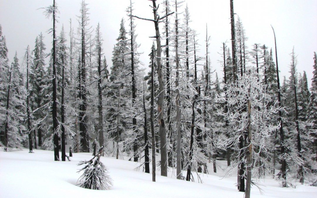
Head north, away from the lake generally following the contour of the land, slowly gaining elevation and entering an area burned by the B&B fire. The fire burned about 95,000 acres in 2003. It looks like a lot of the burned trees have fallen over during the storms of the past decade and the silver forest is fairly open. Coming into the stream valley, continue uphill until finding a good place to cross the stream. Continuing to follow along the ridge, head generally east for about a mile.
In the burned-out area, we found a fallen log for lunch and hoped the clouds would clear. We talked about the hike and what was the best route to take to where we wanted to camp. The waypoint for our lunch was N44 34.534 W121 50.465.
From lunch, the path became steeper. We first climbed a pretty steep, though fairly short slope and continued to follow the ridgeline. Though we couldn’t see the cone, Justin knew the general direction and we continued generally heading east but curving to the south. After lunch we moved out of the charred trees of the B&B fire.
As we continued to climb among the clouds, we used the compass and GPS to head in the general direction of the cinder
cone. We wove through the trees, picking our way through spaces in the trees. There were a few short, steep places but they were in the trees so the avalanche danger was very low.
At about 6,200 feet, we found some good breaks in the trees to contour around the lower slopes of the cone. We had found an alley through the trees and it made for easy travelling. The snow had a thick crust and it was easy to walk.
We scouted around for a camp and backtracked to a flat area that had trees to block the wind a bit.I started my igloo and the rest set up their tents. Jerimiah picked the windiest spot and you could see his tent flapping a lot.
I made a bigger than normal igloo so we could get inside and the construction took about 2 ½ hours. It kept me warm while the others mostly kept to their tents to stay warm. I got done about 5:30 and Justin decided to help build a snow wall to help shield Jerimiah’s tent.
They used extra blocks from the igloo and cut additional blocks for a while. We talked a bit while we made dinner but most of the time was spent in our shelters.
I spent a quiet night only hearing a bit of wind on occasion. The wind died down during the night but the clouds remained. We still couldn’t see much the next morning as we made breakfast.
We decided that our route as pretty good so we followed it back as best we could. Sometimes we could see our tracks and other times not. The map shows the terrain as relatively gentle, but there is a very steep slope to the south of our track and boulder fields.
Once we reached our Saturday lunch spot, the slopes were pretty gentle. We found our stream crossing without a problem. The sunlight and clouds made interesting patterns with the trees which are a mix of silver-grey and charcoal black. All the small branches have been burned away and only the skeletal frameworks of the trees remain. From our lunch spot, it was easy to navigate back to Marion Lake. We alternated wearing snowshoes and carrying them.
Marion Lake was mostly frozen over but seemed to have a couple of interesting patterns which we think were made by water upwelling and keeping the ice from forming a thick layer. We walked the rocky trail above the lake, then continued through a flat forested area for just a couple tenths of a mile then traverses back across the steep slope. Even though I tried to avoid walking over the trail, I still fell through in a spot up to my hips. The rest of the group navigated the slope without plunging through to the trail.
Back in the forest the slope lessened and walking became easier. The trees help shield the trail from high snow accumulations. We soon came back to the shores of Lake Ann which looks like it stays unfrozen during the winter.
We carefully negotiated the logs at the outfall of the lake and went back into the woods. There were still deep patches of snow where you step into a footprint thinking it will hold, only to posthole up to your knee. Those patches lasted about .5 mile and from there it was a pretty easy walk. We enjoyed finishing up our trip on a trail that has a nice consistent grade downhill for the last mile.
We got back to the pit toilet about 2 in the afternoon and I enjoyed not having to use a blue bag on the trip. We met a couple of people going for a day hike, but other than the two people we saw on the first day, we had the wilds to ourselves.
I hope we can see some mountains on the next trip. The scenery should be fantastic on a clear day. Thanks to Justin for organizing this trip to a quiet place of solitude and snow.
Enjoy the photos!!
Gallery Pics
Switchback Steve
Recent Comments