

Vicinity Location:
Mt. Rainier National Park
Location:
The trailhead is 52 miles southeast of Seattle and 104 miles northeast of Portland.
Directions:
Drive I-5 N for about 130 miles, passing through Olympia.
About 20 miles past Olympia, take Exit 127 and merge onto Hwy 512 E towards Puyallup and drive 11.9 miles.
Merge onto Hwy 167 N for 1.1 miles and then take Hwy 410 E exit towards Sumner/Yakima.
Continue onto hwy 410 E for 10.8 miles.
Just past a sign that says “Entering Buckley”, turn right onto Mundy Loss Rd East and drive 1.1 miles.
Turn left onto Pioneer Way East Road (Hwy 162 E) and it turns into Hwy 165 S after .2 mile. Follow the signs towards Wilkeson Carbon River ranger station and in 10.5 miles the pavement ends.
The next 14.8 miles is a slow, bumpy, washboard road to the parking lot for Mowich Lake.
Note: This road is closed in the winter and parking fills up on summer weekends.
Length and Elevation:
Total distance is 18.5 miles. Trailhead elevation is 4,935 feet. Highest point is 6,320 feet. Lowest point is 2,484 feet.
Total elevation change is 5,000 feet up and 5,000 feet down.
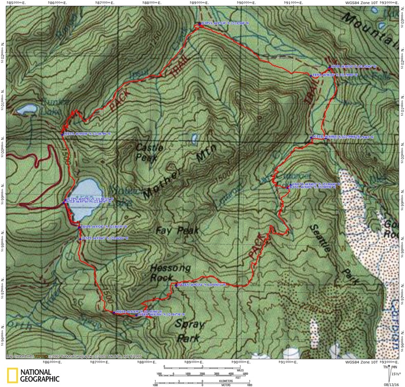
Trail Maps:
Topo Map, National Park Service Map, Download Garmin .gpx file
Review: 7/26/2016
The trailhead for Spray Park is easy to find; just walk into the Mowich Campground past the bathrooms by about 50 feet, and the trail is off to your right. Descend several wooden treads into the forest listen to the sounds of the nearby stream. After less than a quarter-mile you descend down to the junction for Spray Park Trail. Take a left here and enjoy the sights, scents, and sounds of Mount Rainier National Park.
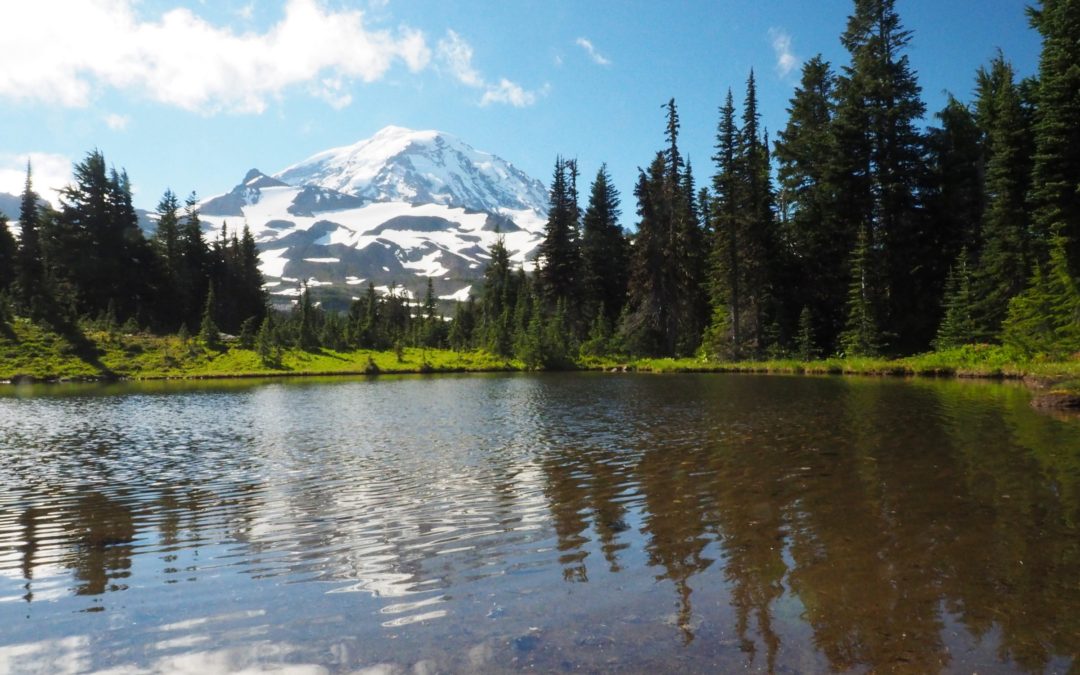
A little over a mile the trail finishes its descent to pass below some rocky cliff and from there begins a steep climb up at least a hundred wooden treads along the forested mountainside. You soon pass a viewpoint on the right which has a very nice view of Mount Rainier. Continuing on about 1.9 miles from the trailhead is the junction to Eagle’s Roost Campground where there is a pit toilet and a view of Mt. Rainier.
Continue along the side of a steep slope to the junction to Spray Falls and take the trail on the right, going down across a scree field to Spray Falls. Pick your way across Spray Creek for the best view of the falls. The falls drop a total of 354 feet then tumble down the rocky streambed creating a fine spray over the trail.
After taking a side trip to spray Falls, it’s about three and a quarter miles from the trailhead where you enter spray park which has beautiful meadow vistas of the nearby mountains and of course Mount Rainier. The trail is mostly graveled with a few muddy patches, but it’s easy to keep your feet dry along this section of the trail.
Continue upward through Spray Park with spectacular views of the wildflowers, Mt. Rainier, and the surrounding mountains. At about four and a half miles the landscape changes from a mossy forest to a volcanic zone with pumice type rocks everywhere and the trail much rougher. From here there’s a good chance you’ll walk over some snow fields as you climb up to the highest point on the trip.
After dropping down about 1,000 feet back into the forest and travelling 7.6 miles from the trailhead you come to the junction of Cataract Valley Camp, just off the trail. Most of the year this camp has a nice supply of water but it can stop running in dry years. This could be a nice place to stop for lunch, sit by the stream, and resupply water if there aren’t many mosquitoes and black flies.
When you get down to the bottom and reach the creek just over 9 miles from the trailhead the trail to the campground is washed out you have to turn right and go I guess up to carbon. When you reach the junction for Ipsut Campground turn left and you’ll drop down across the little clear water tributaries of the Carbon River. Pay attention to the little cairns which people leave and also places where rocks are piled to cross little streams. The trail pretty much cuts straight across the rocky streambed towards the Carbon River. Crossing the main branch the water is about a foot beneath the bridge on a warm day and you can hear rocks tumbling down the river through the dirty water. It looks like the bridge washes out just about every year. From the bridge there’s some views of Mount Rainier up the Carbon River.
About a quarter-mile Downstream from log crossing the trail comes out on to the fairly open hillside and traverses along the carbon River. From here there’s nice views down and across the valley and also at the destruction the Carbon River has wreaked on the forest that it passes through. At 12.8 miles you come to the junction back to Mowich Lake on the Wonderland Trail. What’s left of Ipsut Campground .3 mile down the trail. This junction is the lowest elevation point on the trail at 2,484 feet.
It is now 5, mostly uphill, miles back to the car starting in a nice forest then climbing up to the head of the valley. Cross many streams as you climb beside Ipsut Creek through several climate zones as the surrounding terrain steepens and the plants change to slide alder and wildflowers grow along the trail. Finally you pass beneath cliffs and go through the tiny gap of Ipsut Pass at elevation 5,150 feet.
From the gap the trail changes completely to a wide, gently descending trail as it drops a few hundred feet and passes the junction to Eunice Lake, and then down to Mowich Lake. Walk above the lake for about .3 mile, then along the lakeshore for another .3 mile. Take a couple of little side trails on the left to viewpoints along the lake of Mt. Rainier. From the lake, climb a bit into the campground and find your way back to the restrooms.
This dayhike took about 8 hours to hike with plenty of stops for pictures. The terrain varies from rain forests to alpine wildflowers to snowfields that last well into summer.
Enjoy the photos!!
Gallery Pics
Switchback Steve
Recent Comments