

Directions:
In Portland, OR, Take I-5 to I-405. Exit towards St. Helens onto highway US-30 W. Go about 1/3 mile, looking for the NW Vaughn Street exit. Bear Right on NW Vaughn St. Turn Left on NW 26Th Ave – go 0.1 mile. Turn Right on NW Thurman St. and go about .2 mile. Turn right onto NW 26Th Ave and turn left in one block onto NW Upshur St. Continue 2 blocks and arrive at the parking small parking area below the Thurman Street bridge. You will probably end up parking on the street.
No parking permits are needed. Parking lot fills up by 7:00 or 7:30 am on summer weekends.
Bathrooms are in the small green house on the right side of the park.
Mountain bikes are allowed on Leif Erikson trail and most firelanes but not the Lower Macleay Trail, Wildwood Trail, Dogwood Trail or Aspen trails.
Portland law requires dogs to be on a leash at all times while in the park. Dogs must be leashed prior to entering and when leaving the park. You are also required to pick up after your dog, not kick it off the trail. In actual practice, about 20% of dogs are leashed on the trails.
Length and Elevation:
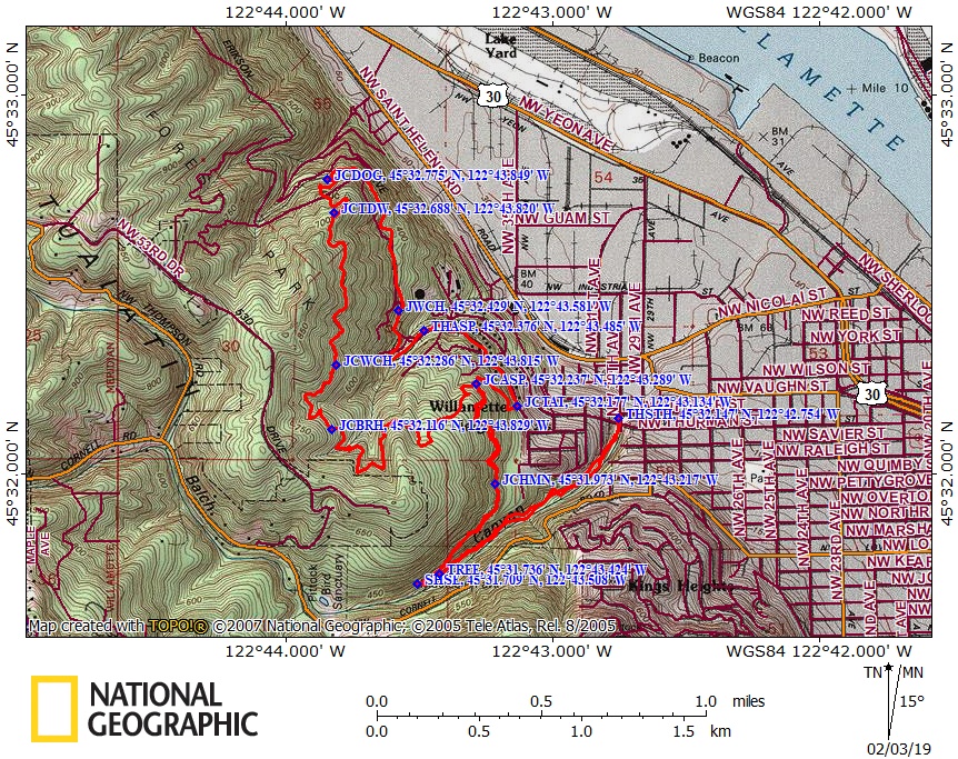
7.6 Miles round trip. Elevation gain is about 740 feet and the loss is 50 feet to the upper junction of Dogwood Trail. Total gain and loss is 1,580 Feet. Elevation at the trailhead is 100 feet. Elevation at the upper junction of Dogwood Trail is 790 feet. High point is about 790 feet.
Trail Maps:
Topo Map, Topo Map – The Art Of Geography, Download Garmin .gpx file
Trail:
Lower Macleay Trail, Wildwood Trail, Dogwood Trail, Leif Erikson Trail, Aspen Trail with connections to the Wild Cherry Trail, and Holman Road.
There is at least one geocache along this trail at: N 45° 34.095 W 122° 46.115 Info at Geocaching.com
History:
There is one other large Forest Park in the United States. It is in St. Louis, MO. and is about 1,293 acres in size. Forest Park in Portland is over 5,100 acres in size. A century ago the old growth trees in the hills above Portland were being cut down for the city. Fires also burned in the park in the 1940’s and 1950’s burning over 2,000 acres. There has been support for preserving the hills as a park since the 1870’s as well as plans to develop the park for homesites. Rumors of oil created a rush to drill wells, but no oil was found. The idea of a park continued to gain favor and Forest Park was created September 23, 1948. The park was originally 4,200 acres in size and has had small tracts of land added over time and has become the largest urban forest park in the United States.
Review: August 19th, 2010, February 2nd, 2019
Forest Park has numerous trails throughout its length. The south end Forest Park is bounded by Washington Park which contains the Children’s Museum, Hoyt Arboretum, Oregon Zoo, Japanese Garden, Vietnam Memorial, World Forestry Center, and International Rose Test Garden. This hikes starts north of these tourist attractions.
Since this trail is within a metropolitan area, it is well maintained and gets very busy when the weather is nice. Mountain bikers, hikers and runners along with their dogs use the Leif Erikson section of this trail heavily.
There is trail signage at the trailhead showing several of the trails and trailheads. The trail starts out as a paved path and crosses under the Thurman Street bridge and past where Balch Creek disappears beneath the city.
After a short distance the trail crosses over Balch Creek and becomes a packed-dirt trail. From the bridge the trail climbs gently along the embankment, passing a nice stone bench along the creek.
In about .4 mile, the trail crosses back over Balch Creek on an artistically designed bridge. Just after the bridge is a nice stone bench with forest flora and fauna etchings covering the top of the bench. From the bridge the trail continues along west bank of the creek. From the trail you can hear the pleasant noises of the summertime brook flowing along the side of the trail. After long dry periods, the plants along this section are covered in a velvety layer of fine dust from all the foot traffic on this trail.
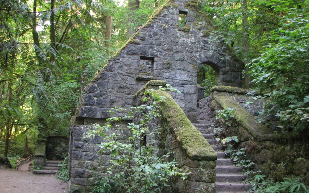
After .75 mile is the junction with the Wildwood Trail and the Stone House. The moss-encrusted house was a public restroom built during the Great Depression by the Works Progress Administration (WPA) in the 1930s. It was often vandalized and after the house was damaged in the 1962 Columbus Day storm it was closed and partially demolished.
At the Stone House, make a sharp right and head up the Wildwood Trail.
Just before 1.25 miles is a 4-way junction with Holman Lane. Continue straight across, staying on the Wildwood Trail, which continues a moderate elevation gain. In about .3 mile is the junction with the Aspen Trail. The trail going off to the right will be the return loop. Keep to the left here, continuing on the Wildwood trail and climb a few switchbacks.
At about 2.5 miles from the trailhead is the junction with the Birch Trail which branches off to the left. Continue straight on the Wildwood Trail as it winds through the forests, undulating along the contours of the West Hills.
At 2.75 miles the Wild Cherry Trail crosses the Wildwood Trail. It isn’t exactly a 4-way junction. The right branch of the Wild Cherry Trail heads down to the Leif Erikson Trail. Continue on the Wildwood Trail through the forest and ferns. There is an amazing variety of plant life for this trail being so close to a large city.
The Dogwood Trail is the next trail after the Wild Cherry Trail. Though the Dogwood Trail wasn’t signed at the time of this review, it is one of the few 4-way junctions. The junction is in a circular clearing. Turn right onto the Dogwood Trail and follow the ridge to the right for about 100 feet before dropping down and switchbacking down to Leif Erikson Drive where you turn right. There are limited views of the Portland industrial area along Leif Erikson Drive. Follow the dirt and gravel road to the trailhead at the end of Thurman Street.
At the Thurman Street trailhead, head on the road downhill and turn right and walk along NW Aspen Avenue for about .3 mile to the Aspen Trail trailhead. Turn right and follow this steep trail back up to the Wildwood Trail, turn left, and retrace your earlier path back to the Stone House. Turn left again at the Stone House and follow the trail downhill along Balch Creek.
About 500 feet from the stone house is a Heritage Tree marker along Balch Creek. This shows the largest tree in Forest Park, which is a Douglas fir. The tree is 242 feet (74 m) high, and the trunk is more than 4 feet across, or just over 17 feet (5.3 m) around.
Continue to walking along the creek and underneath the Thurman Street Bridge, back to the Lower Macleay Trailhead. Since this park is in an urban area, take considerable thought before venturing off-trail. Law authorities occasionally find marijuana plants being cultivated in the park. People who cultivate these illegal plants can be very protective of their plot and don’t take kindly to people stumbling upon their crops. About 100 plants were seized in October, 2007.
Overall this is a great trail for a cloudy day and very child-friendly. There are some steep hillsides but no cliffs along the downhill side of the trail. All the unleashed dogs I saw were out for a romp and not interested in other people.
Enjoy the photos!!
Gallery Pics
Switchback Steve
Recent Comments