

Vicinity Location:The trailhead is 33 miles northeast of Portland, OR in the Columbia River Gorge.
Directions:
Download Garmin .gpx file for gps route from Beacon Rock State Park and Highway 14.
Text directions are sketchy. From Portland take I-205 North; drive past the Portland Airport Exit and cross the Columbia River. Move over to the right lane as you cross the bridge. Take exit 27 for Vancouver/Camas and move into the left lane on the off ramp heading towards Camas. Follow SR-14 to Beacon Rock State Park which is just before Milepost 35.
Kueffler Road comes up just before the Park Headquarters of Beacon Rock State Park. This is a Y-Intersection and if you miss Kueffler Road, you can turn left about 50 feet after the Kueffler Road street sign.
Follow the winding paved road uphill about 2.5 miles and it turns into a gravel road. About 1.6 miles from Highway 14 is a sign that says “Private Road” that has been put up by local residents. This is not a private road. Continue up the gravel road and it turns into a dirt road.
Make a left off of CG1420 onto CG1400. Turn left off of CG1400, pass some concrete blocks on the right, turn right at yellow metal gate.
Follow GC1500, looking for a quarry area with the Pacific Crest Trail crossing the road just after the quarry. This is where the trailhead is located.
To get to the trailhead from the parking area, walk east and look for the trail. The Pacific Crest Trail will be on the left side of the small ridge.
There is no bathroom at the trailhead. The closest public restroom is at Beacon Rock State Park equestrian trailhead.
No permits are needed to park at the trailhead.
Length and Elevation:
12 miles round trip Elevation gain 3,300 feet and loss of 3,300 feet. Total gain and loss is 6,600 feet. Elevation at the trailhead is 2,400 feet.
Trail:
Pacific Crest Trail #2000, Heartbreak Ridge Trail, Bushwhack Trail with connections to West Ridge Trail.
There is at least one geocache for this trail but it is only available to premium members.
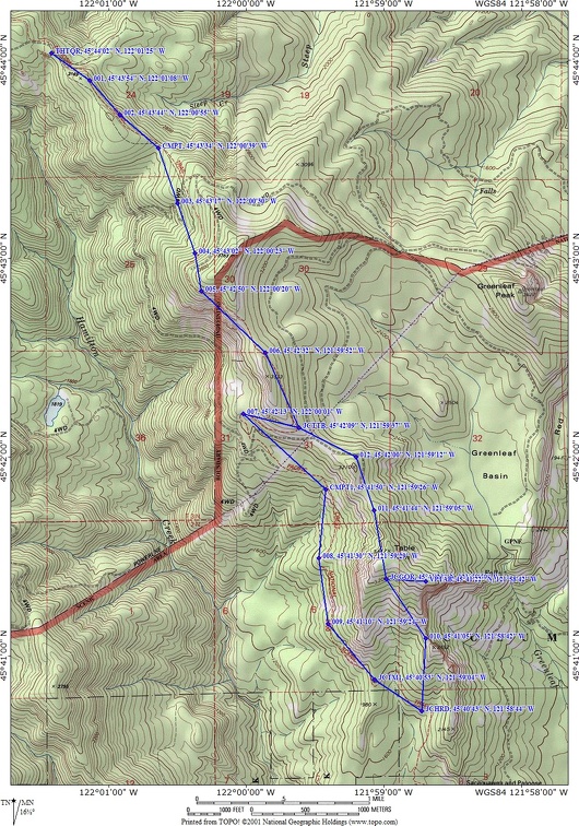
Trail Maps:
Topo Map, Download Garmin .gpx file
History:
The Columbia Gorge has some interesting volcanic geology. In the Columbia River Gorge there are layers of lava and volcanic debris which are tilted down towards the Columbia River on the Washington side and of course, tilted up and away from the Columbia River on the Oregon side. Near Bonneville, Oregon, the lava layers making up Table Mountain slid into the Gorge about 1450. This series of four landslides, covering five square miles, blocked the Columbia River. In pictures of Bonneville Dam, the Second Powerhouse butts against this landslide. The cliffs of Table Mountain were created because of the slides.
Native Americans in the area would have marveled at the 200 foot (60 meters) high landslide blocking the Columbia River. They could have crossed to what is now Oregon on foot, probably giving rise to the story about “The Bridge of the Gods”. This natural dam created a lake that backed up the Columbia River almost seventy miles (up to the present day John Day Dam).
After a few months, the Columbia River rose high enough to breach the landslide on the southern side creating a flood of water that was 100 feet (30 meters) deep at Troutdale.
The slide displaced the riverbed a mile to the south and created a set of rapids, the Cascades. In 1938 the rapids disappeared under the lake created behind Bonneville Dam. The only remnants is the concrete structures for the navigation lock at Cascades Locks which was built in 1896 to allow boats around the rapids.
The latest landslide occurred in early 2008 below Table Rock and wiped out everything in its path. Luckily there was no one in the area.
Review: July 8, 2012.
From the trailhead at the quarry site, head into the woods along the forested PCT (Pacific Crest Trail). Looking downslope you can see a logging road for about .1 mile. The trail continues down for about .8 mile to cross a little used road with an adjoining campsite. This is a nice flat area but appears to be a dry camp.
Continue along the PCT for the next couple of miles through the forest, sometimes up and sometimes down. The trail nears a large powerline and crosses several clearings as it now drops down, then crosses underneath the powerlines.
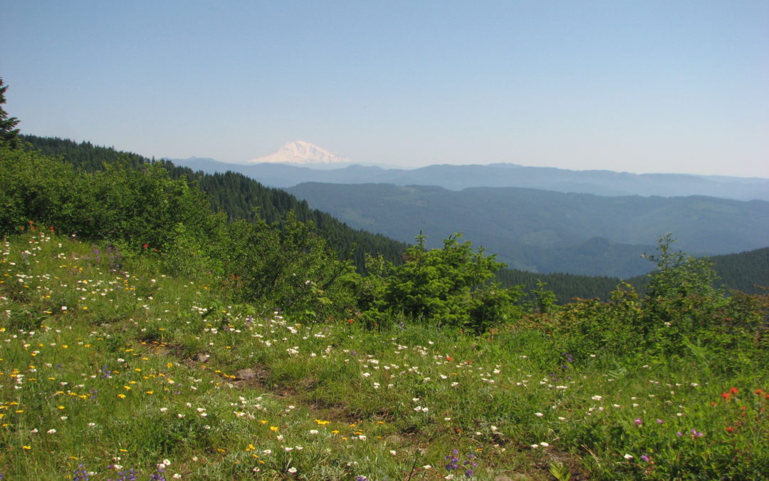
From the clearing you now have a view of Table Mountain to the south. The trail leads back into the woods and you may notice some long abandoned steel logging cables. One chunk of cable serves as a step in the trail.
The trail heads along the base of Table Mountain for another couple of miles, then climbs up to the junction for the West Ridge Trail to Table Mountain where there is a kiosk marking the trail. For this hike, pass this junction and walk about .25 mile to the next trail junction with a kiosk. Turn left here at the Heartbreak Ridge Trail and begin climbing up towards Table Mountain.
The trail climbs for the most part but has some loss of elevation, then comes out to a ridge that connects to Sacajawea and Papoose Rocks on the right. There are spectacular views of the cliffs of Table Mountain and you can see where the ancient landslide filled in the river and moved the river channel to the south. Enjoy the viewpoints along the ridge for a short distance then drop down on the west side for about .1 mile.
Now the trail starts climbing in earnest. There are places were steps were placed though some have eroded out. This is not a good trail on a wet day with the slippery soil and high underbrush.
Continue climbing without a break until you come to the bottom of a long talus slope. Pick your way through the unstable rockfield, climbing about 300 feet. Re-enter the forest and soon come to a trail junction back to the PCT and to Table Mountain. Take the junction to the right and continue on to Table Mountain.
Once on top, there are several choices. The trail to the right goes out to the cliff face. The trail to the left goes across Table Mountain to views to the west and south.
From here, you can return to the junction for the PCT and go down the West Ridge Trail then back on the PCT, or if you are adventurous, you can take the user-trail off the northwest side of Table Mountain.
This can also be made into a shuttle hike by parking a second car at the Tamamous Trailhead, or just west of the Bridge of the Gods, next to where the PCT meets Highway 14.
This hike is not recommended for inexperienced hikers due to the steep slopes and cliffs along the trail. There also is no water for dogs along the trail. For a water source you have to drop off the trail to find a stream, or continue south on the PCT to find a stream.
Enjoy the photos!!
Gallery Pics
Switchback Steve
Recent Comments