
Vicinity Location:
The trailhead is about 37 miles east of Portland, OR in the Columbia River Gorge.
Directions:
From Portland, Oregon, there are two ways to drive to the trailhead. If you have an extra 30 minutes then make your trip a loop drive.
For the loop drive, take I-205 north across the Columbia River. Exit I-205 on HWY 14 east for about 25 miles to the town of North Bonneville and park at the Bonneville Trailhead.
For the non-loop option, take I-84 east from Portland and take exit #44 for Cascade Locks. Take the first right turn, just after you go under the Bridge of the Gods. Pay the $2.00 toll, cross the bridge, and turn left onto HWY 14 and drive 2 miles to Bonneville Trailhead parking lot on your right.
To return, take HWY 14 east for 2 miles, turn right and cross the Columbia River at the Bridge of the Gods. The toll is $2.00 for the bridge. After the bridge, the road loops around and intersects Hwy 30, Cascade Locks Hwy, near the base of the bridge. Turn left here and you will merge onto I-84 west in about ½ mile. Follow I-84 west, back to Portland.
A Northwest Forest Pass is required at this trailhead.
An outhouse is available near the parking lot.
Length and Elevation:
15.3 miles roundtrip. Elevation gain 3,600 Feet and loss 100 feet to the turn-around point. Total gain and loss is 7,300 Feet. Elevation at the trailhead is 100 feet, the summit elevation is 3,600 feet.
Trail:
Tamanous Trail #27, with connections to the Pacific Crest Trail Trail 2000.
Trail Maps:
Topo Map
Review: April 29, 2007
There is a kiosk displaying trail maps near the outhouses. There are signs indicating a Northwest Forest Parking Permit is needed. The trailhead is just to the east of the turnaround at the end of the parking lot. The sign says Tamanous Trail #27, Pacific Crest Trail .6 miles. Horses and hikers use this trail so remember to stop and step to the side of the trail when you see a horse. The well maintained trail goes uphill and levels off with a nice treed view of the Columbia River. Near the trail is the Burlington Northern Railroad. There is a train tunnel that passes unseen underneath the trail.
At the junction with the Pacific Crest Trail, head north on the Pacific Crest Trail (PCT). You will soon see a small lake in the distance, but there will be access to other lakes along the trail for wading or swimming. The trail goes through old clear cuts and parallels a jeep trail. Don’t forget to watch out for poison oak along the trail. Some of the poison oak is waist high.
The trail crosses a powerline access road and continues down underneath the power lines past a nice lake. Follow the trail down to Gillette Lake and then the trail takes a right, goes uphill a bit and crosses the stream that comes into Gillette Lake. Cross the log footbridge and continue on the PCT. The trail switchbacks up from Gillette Lake and crosses a natural gas pipeline right-of-way and then follows a service road for a small distance before branching off on the right side of the road. There are markers on the trees to guide you so that you don’t lose the trail. The trail passes another small lake and comes up to another road crossing. Soon after the road crossing is a view of Table Mountain with vine maples in the foreground. This looks like a place with spectacular fall colors when the vine maples turn red and orange in October. The trail drops down and crosses another creek on a sturdy footbridge and switches back. Follow switchbacks down to a footbridge crossing. The trail twists and turns on the way to Table Mountain.
Another bridge crosses Greenleaf Creek and the trail continues uphill to the first clear viewpoint looking into the Gorge. The elevation here is just over 600’ even though you may think you have climbed higher. Continuing through the woods, the trail continues to gently climb and you’ll find an all-year spring that comes out right at the trail. Shortly after the spring, the trail crosses a 4-wheel drive road and you will see the trail branching off to the right. You will see a PCT trail marker sign that confirms you are on the PCT. The trail goes down the hill and there is a bridge across a small, fairly small moving stream. You will find a camping spot about 200 feet before the bridge, and a camping spot next to the stream at the bridge. Soon the trail goes through the valley of the stinging nettle. You want to be careful of bare arms and legs in this valley. The trail crosses a small stream and then follow the babbling brook upstream. The trail leaves the stream and ascends several switchbacks. At the top of the last switchback there is some flagging where an older, less used trail joins the PCT. You can hear a stream in the valley to your left and the trail climbs just below the ridgeline.
After climbing a bit more, the trail crosses the 4-wheel drive track again. Just look for the PCT marker on the trail about 50 feet off the 4-wheel drive track. After about ¼ mile, or so, the trail crosses the 4-wheel drive track again and peels off to the right. Just look for the PCT marker on a tree just off the trail.
The understory along this part of the trail supports plans that like damper areas. There are Violets, Epimidiums, vanilla leaf, Oregon Grape, and Sword ferns. The trail starts ascending fairly steeply and pretty soon you come to the last good source of water. It is a spring that comes out just above the trail. Tank up for the steep climb ahead.
Just after the spring is an old trail up Table Mountain that is closed due to trail erosion and damage to the sensitive ecosystems. There is sign that asks you to access Table Mountain using the trail ½ mile ahead. That is the less steep trail, so it sounds like a good idea.
The junction to Table Mountain is where the PCT crosses ridge that juts out from Table mountain. There is a large sign noting the trail and a boulder about the size of a Volkswagon Beetle sitting off to the right.
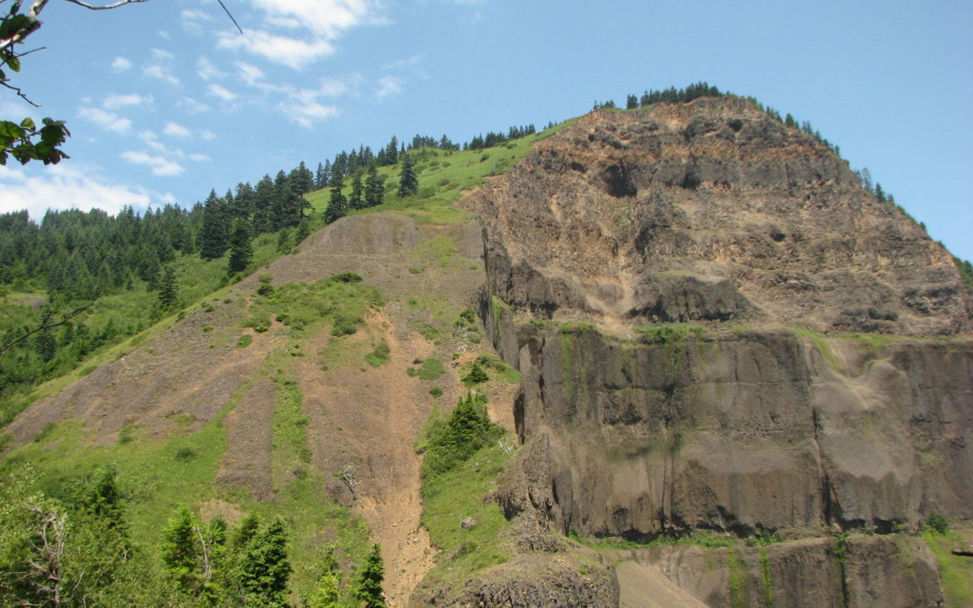
The trail gets steep and you will get into loose basalt rocks on the trail. Suddenly the trail comes out of the trees on a rock field. The trail is easy to follow with no chance of getting lost here. The trail ascends along a ridge, going in and out of trees. You are close to the edge of a very tall cliff. This is not a place to take small children.
Near the top, stop to admire the giant ant mound. It is incredible that these ants are able to survive here in this inhospitable weather. Admire the view at the top and see how many peaks you can see along with what wildflowers you can find. Heading back, turn left after about 200 feet at a footpath junction and follow the trail into the trees. You will come out on another ridge and the trail leads to another viewpoint. This viewpoint of the gorge has cliffs that drop over 1,000 feet on one side. Just before you get to the viewpoint, you will see where a landslide had taken out part of the trail. The landslide that took out this portion of the trail must have been a sight to see from down below.
Be careful about catching your trekking poles in the rocks on your way down. Mine got stuck a few times going back down. There are some cairns along the way to mark the trail. This is especially helpful if there is any snow along the trail. Don’t forget on the way back, after you cross the stream by Gillette Lake, the trail goes up not down. If you take the trail down, you will think it is a little narrow and you will end up at the lake.
On this trail, you really notice the last few miles to the trailhead how the trail winds back and forth, and up and down. You don’t gain or lose much elevation but after hiking to the top, the little hills and dales slow you down and wear you out.
Enjoy the photos!!
Gallery Pics
Switchback Steve
Recent Comments