
Vicinity Location:
About 168 miles northeast of Portland, OR. and 75 miles east of Seattle.
Driving Directions:
From Seattle, take US2 east towards Wenatchee to the outskirts of Leavenworth. Look for Icicle Creek Road and turn right. At about 4 miles, the Snow Creek Trailhead is on your left.
To reach the Lake Stuart Trailhead, continue about 4 miles and turn left on road 7601 (about a mile past the Eightmile Campground). After the turn, stay straight (left is the Bridge Creek Campground) and follow the road to the trailhead. The first trailhead you will encounter is the Eightmile Trailhead. Continue driving on road 7601 about a mile to the end of the road and the Lake Stuart Trailhead.
Length and Elevation:
24 miles one-way. Elevation gain 9,000 and loss 7,200 to Lake Stuart Trailhead. Elevation at the Snow Lakes trailhead is 1300 feet. Elevation at the Lake Stuart Trailhead is 3,450 feet.
Wilderness permits are required until after October 31st of each year for day hiking. Between May 15 and October 31, a reservation permit is required for overnight use in the Enchantments. You can do a walkup or register for the annual lottery through Recreation.gov
Other rules and regulations:
Group Size
- Eight (8) people is the maximum allowed together in any of the permit zones.
- All group members must begin on the reserved trip start date and must camp with the permit holder.
- You may not exceed the limit at any time or anywhere while camping or travelling.
- Groups with pack or saddle stock may not exceed a total of eight persons plus head of stock. (4 people + 4 mules = 8).
Campfires:
- Fires are prohibited nearly throughout the Enchantment Permit Area; no fires anywhere above 5,000 feet or within 1/2 mile of any lakes, and no fires during times of high fire danger. Bring a stove.
Pets:
- Dogs are prohibited, as are any other pets, throughout the permit area.
Goats and other Wildlife:
- Do not feed mountains goats, jays, or any other wildlife. Hang food, toiletries, and other attractive items when in camp, and keep food and camp waste where bears, mice, and other animals cannot reach.
- Do not urinate on vegetation or soils or within campsite areas, as this encourages goats to become habituated to human contact and leads to abnormal and aggressive behaviors.
- Discourage wild animals from becoming too tame – enjoy them from a distance that is safe for both you and them.
Campsites:
- All members of a permit group must camp together.
- You may only camp in the permit zone(s) listed on your permit.
- Camp only at established campsites-do not camp on vegetation, move rocks, build walls, or disturb soils to improve a site.
- Make camp early in the day to ensure finding an available campsite.
- It is illegal to cut any standing tree, dead or alive, damage vegetation, or damage any natural feature for any reason.
Toilet Facilities & Water Quality
- Use toilets where provided. Do not put trash into toilets, use them for their intended purpose only.
- Do not urinate on vegetation or soils. Use gaps between boulders, crevices in rocks, large flat rocks, sandy bare areas, or the toilets provided. Urine attracts goats and leads to pawing and chewing of plants and soil and is a cause of abnormal aggressive animal behavior.
- If you’re not near a latrine, dig a small hole 6 to 8 inches deep at least 100 feet or more back from water sources or campsites. When finished, fill hole and cover with soil.
- Bathe and wash dishes at least 150-200 feet from lakes and streams.
- All soaps pollute water including soaps labeled biodegradable.
Pack and Saddle Stock:
- Groups with pack or saddle stock may not exceed a total of eight persons plus head of stock. (4 people + 4 mules = 8).
- Stock are not allowed on the Snow Lake and Colchuck Lake Trails, and are only allowed on the Stuart Lake Trail in the fall from the first Saturday after Labor Day until the end of that year.
- Stock may not be grazed, tied, hitched, hobbled, or held within 200′ of any lake or pond.
- Camping with stock in the permit area is allowed only at the designated stock site at Upper Caroline Lake or other suitable sites more than 200′ from water. No camping with stock within 1/2 mile of the Eightmile Lakes.
- Stock may be tied directly to trees only for short periods of time, not to exceed 4 hours, and not to trees of less than 6 inches diameter.
Food and Fish Remains
- Hang all food in a bear-safe manner, or use bear-proof containers.
- Try to plan your meals so you don’t have leftovers. If you do, pack them out. Do not feed wildlife or leave food waste for them to find.
- Dispose of fish remains well away from campsites, trails, portages and shorelines.
Storing or Caching Supplies:
- It is illegal to leave camp gear or any other supplies or materials unattended for more than 48 hours.
- Geocaching is prohibited in all designated wilderness areas. Please practice this sport elsewhere.
- All litter, trash, equipment, and personal property must be carried out with you at the end of each trip.
Trail:
Snow Lakes Trail 1553, Colchuck Lake Trail 1599.1, and Lake Stuart Trail 1599
There is at least one geocache along this trail at N 47° 29.905 W 120° 50.003. Info at Geocaching.com
Trail Maps:
Topo Map, Rain and snow forecast, Download Garmin .gpx file
Review: July 20, 2011
The Enchantments 2011
Day 1 – Snow Lakes Trailhead to Upper Snow Lake
Drew and I started planning this trip at the beginning of 2011. I checked out a couple of books from the library and decided to start at the Snow Lakes trailhead. Upon further research I found out the main road, Forest Road 76 had been closed for the past few years at the Ida Creek campground, about 3 miles from the Jack Trail trailhead. The alternate plan was to come out at Eightmile Lake trailhead.
This route would take us through the Enchantment Lakes and over Aasgard Pass, a very steep descent to Colchuck Lake.
The permit system is very restrictive so we tried to line up people who wanted to backpack The Enchantments. We got some maybes but no commitments.
In March, we applied for permits with alternate dates and won a trip through the lottery system. The process allows 14 days to confirm with the names of the party of up to 8 people. I didn’t set a reminder and my permits expired. The system sends an email after the permits is revoked and Drew and I saw the emails. Drew got online and was able to reserve a trip through but without a night in the Enchantment Lakes zone.
I felt really awful that I had let the permits expire but thankful that Drew got a set of permits. Now four of us were on the permits to go; Drew, Zach, Bob, and me. The trip begins July 17th and lasts five days.
We talked about the trip as we heard about snowfalls setting records. We went over our lists of what to take and how much things would weigh. We had to decide if we wanted crampons and ice axes. We speculated about how bad the bugs would be. We tried to figure out if all our gear and four people would fit into a Toyota Prius.
The snows melted slowly through the cool spring and additional snowstorms dumped even more snow at the higher elevations in May but our dates were set. I called to see about adding a day but the Forest Service doesn’t allow that. I would have to cancel my reservation and start all over, and of course, all the good dates had long ago been taken. I did find out that when the Forest Service office closes for Saturday afternoon, the permits are put in a box and they can be picked up Saturday evening or Sunday. Next, I made reservations for a campground in town and for a shuttle so we could drop off our car at the far end.
We left the Portland area about 2PM and arrived in Leavenworth about 7PM. We found the campground, gout our permit from the Forest Service office, and found the turnoff for Icicle Creek road, the road that leads to the Enchantments trailheads. After that, we found a place for pizza and then off to bed. I was glad to have brought ear plugs because some of the other campers got back after midnight and others were talking until late in the night. It was another reminder of why I don’t like drive-in campgrounds.
Sunday dawned pretty clear and we made breakfast then headed to the Snow Lakes trailhead to wait for our 7AM shuttle. The shuttle showed up about 10 after 7 and Drew followed them to the Eightmile Lake trailhead.
After about 30 minutes, Drew returned in the shuttle and we strapped on our 40 pound backpacks and hit the trail.
Elevation at the trailhead is about 1,300 feet and from there the trail drops down a bit and crosses Icicle Creek, climbs a bit and crosses Icicle Canal. The canal looks like an inner-tube ride but it is signed “NO TRESSPASSING”. From there the trail climbs a series of switchbacks with occasional views of the parking lot and the creek. Most of the trees along this section of trail were burned during a forest fire in 1994 so the hillside is pretty open with the remaining snags creating a silver forest.
The trail climbs and climbs. At times, the trail is pretty good, other times it is littered with rocks of granite. The trail passes by Snow Creek Wall, which towers over the other side of the creek. The wall is a massive slab of granite over 1000, feet high, which is frequented by climbers, though we didn’t see any as we walked past.
About 2.5 miles up the trail the verdant forest returns. There is lush undergrowth and even moisture loving cedar trees growing along the trail. Wildflowers of Fireweed, Shooting Stars, Columbine, and yellow daisy-like flowers abound along the trail.
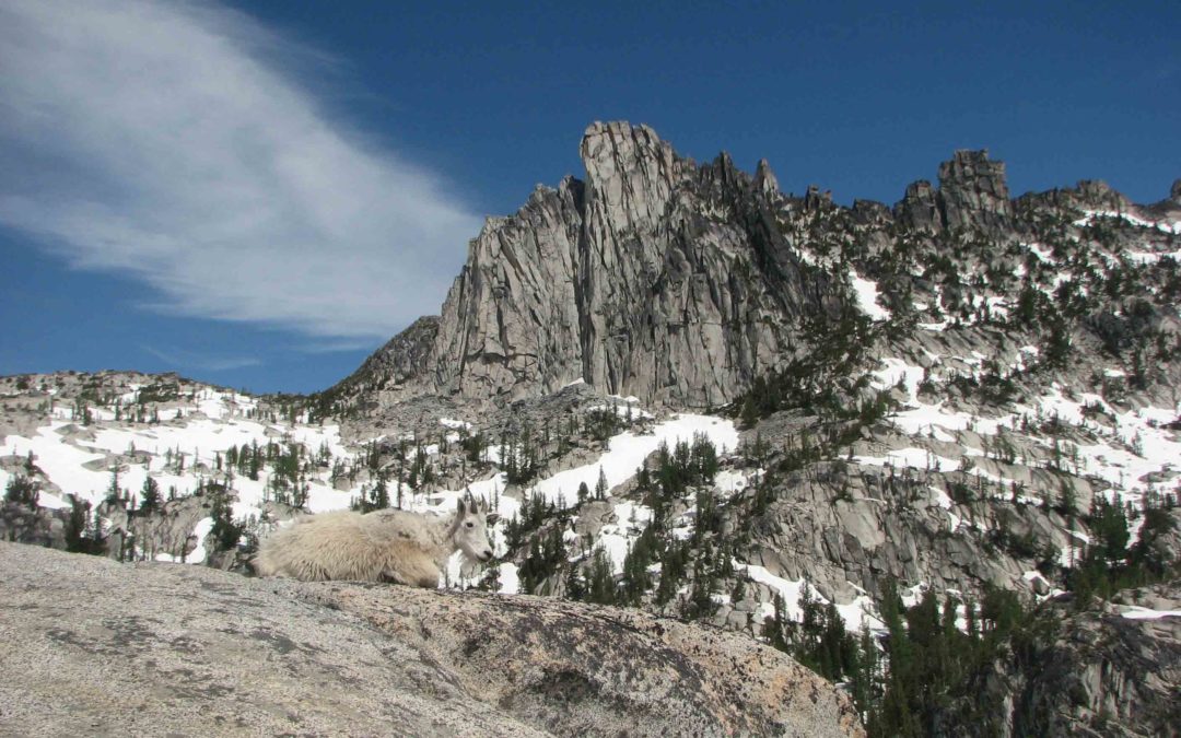
As we got higher, we saw a group of about 12 mountain goats along the trail. Bob and I had to bushwhack a bit to get around one goat in the trail. We stopped for a while to watch the baby goats play along the trail then moved up the trail as the goat’s browsing brought them closer to us. One goat followed Bob for a while and gave him a surprise when it came within five feet of him when he stopped to take pictures of wildflowers.
As we continued our climb up the valley, I was enjoying most of the fragrances of the forest. One place had this alpine type plant smell that I didn’t much like, but the smells from the different trees was wonderful.
We stopped for lunch along a large rocky slope and watched a ground squired scrounge for food. The views of the mountains across the valley were spectacular. Too bad the weather was cloudy. At least it hadn’t poured down rain as it had the previous day.
The trail climbed steeply up to Nada Lake, elevation 5000 feet, which is about 5.5 miles from the trailhead. We stopped to take pictures of a big waterfall cascading off the cliffs above Nada Lake. The stream had several trout swimming below the t falls; some of the fish were over a foot long.
From Nada Lake, the trail climbed steeply up a rocky granite slope up to Snow Lake. Then lake is in a beautiful alpine setting. Looking at the views from the lake, we spotted The Temple to the north, 8,292 feet tall and McClellan Peak to the south at 8,364 feet tall.
The fun part comes when you have to cross a spillway. The water flows anywhere from 2 to 6 inches deep over the spillway during snowmelt and there are small logs in the way too. The spillway is about 2 feet wide and drops off about 6 feet on the downstream side.
I went first with my hiking boots and gaiters, just getting my feet a little damp. Drew and Zach crossed in running shoes and Bob crossed over barefoot. We got across safely but it took a while for their feet to warm up.
Upper Snow Lake is drained throughout the summer to provide water for the Leavenworth Fish Hatchery and was constructed in the 1930’s.
From the spillway, we continued along the lake, gaining 15 or 20 feet, and then dropping back down to the lake. Parts of the trail are boggy but most of those spots have old logs that you can walk across. Most all of the designated camp spots were taken but we were lucky and found two nice spots at the west end of the lake. We took the very last spot with a great view of the lake. The mountains here are spectacular and the creek feeding the lake has emerald green water.
Today we walked 8.5 miles in 8 hours, gaining 4,510 feet and losing 647 feet. The elevation at Upper Snow Lake is 5,445 feet.
Day 2 – Snow Lake to Colchuck Lake
We knew it was going to be a long second day without a core Enchantments campsite. We got up at 5am and made oatmeal for breakfast. I had seen a mountain goat in my flashlight beam when I got up for a midnight bathroom break. The mountain goats are looking for the salt from people’s urine. The Forest Service asks that you not go on plants or the dirt because the goats will eat the plants and dig up the dirt.
After breakfast, we filtered our water from the lake, made our toilet stop without walls, and headed out.
The trail immediately starts climbing alongside of roaring Snow Creek, which is the inlet to Upper Snow Lake. The trail becomes hard to follow once you reach “The Wall”. This granite hillside is strewn with boulders and exposed bedrock. You have to use your hands in a couple of spots to pull yourself up. There are tree filled views of the lake and a thundering waterfall on the way up. At one point, the trail goes left around a huge boulder and the creek splashes onto the trail as you round the boulder. We had to hunt for the trail here, finally finding a cut log from long ago trail maintenance. Routefinding skills are needed on the section of the trail. Look for old logs with cut ends, stone cairns, and looking back to remember the trail in case you have to backtrack. Just before reaching the top is a good view of Snow Lake far below.
The trail eventually reaches the outflow from Lake Vivane. To the right are nice views down into the lake. Up above the lake on the right is a nice campsite.
The trail continues over the lake outlet and climbs above the lake. We stopped for a while to watch two young mountain goats browsing and playing. They were not afraid of us and stayed pretty near. They let us take some fantastic shots of them with the peaks for a backdrop.
The trail was hard to find with all the snow still on the ground so we followed tracks as best we could. The views of the mountains and lakes are breathtaking. Prusik Peak, at 8,000 feet, dominates the view with its lone spire of granite thrusting into the sky. Most of the lakes were thawing out but some were still completely frozen and snow covered. We saw the gentle slopes leading up to Little Annapurna but with all the snow and having a long day we passed on climbing it. We had to consult the GPS several times to stay on course.
We only saw two guys doing a day hike and a group of six asking us which way to Snow Lake. The trail became obscured with snow much of the time but we did see cairns through most parts of the trail. The sky had dark clouds gathering in front of us and we hoped there wouldn’t be a thunderstorm. We reached the pass about 2PM and Zach and Drew headed right on down. Bob and I stayed at the pass to marvel at the eye-popping views. Aasgard Pass is flanked by two nearly identical spires of towering rock. It reminded me of being in a marble cathedral. Being at the top of the pass is a singularly beautiful view.
A mountain goat hung around for a while then ran over to where I had gone to the bathroom. Bob was afraid the goat would push me out of the way. We took some more mountain goat pictures and finally headed down from Aasgard Pass. My daughter tells me it means place of the Gods and at 7,800 feet high, you can easily feel like you’ve accomplished more than most mere mortals.
We finally headed down what looks like a steep trail but soon turns into a loose-rock descent. There are places where you have to face the mountain and down climb several feet, then look for cairns and continue down. The trail heads off to the right as you go down and passes under towering cliffs of dark granite.
We stopped on the way down to watch a pika. I got a couple of pictures of it but it soon disappeared before I could get closer.
About 2/3 of the way down to Colchuck Lake, the trail changes to boulder-hopping. The rocks vary from car sized to cinder-block sized and they aren’t all stable.
Once down to the lake the trail is close to the lake for the first part, then the trail turns back into boulder hopping.
Crossing a small stream the trail vaguely reappears to the right. Going upstream is a dead end. It is a bit of a scramble to get up to the trail and it isn’t much of a trail. It goes up and down along the west shore of Colchuck Lake. There were some muddy spots in the trail because of the late snows, which made plenty of places for mosquitoes to breed.
We were dog tired after being on the trail for 10 ½ hours and w found a great campsite overlooking the lake.
We got situated and made dinner and relaxed for a bit. We were tired and went to bed early and decided to get up at 7AM the next day.
The totals for the day were 6.6 miles in 10.5 hours, gaining 2,950 feet and losing 3,100 feet. The elevation at Colchuck Lake is 5,570 feet.
Day 3 – July 19th
Bob saw a mountain goat when he went to the bathroom last night. Rain started coming down before we were fully awake. It was a steady rain which made us all want to stay in our tents as long as possible. I listened to the patter on the fly and fell back asleep. I woke up just after 7:30 and it was still raining. Good think I didn’t choose a low spot to pitch my tent.
I put off getting out of my bag for another 20 minutes. Today’s trip is short, only 4.5 miles of down, the up to reach Lake Stuart.
We all got out of our tents into the rain at about the same time. It was a pretty quiet breakfast; rain in the morning is never a good start to the day. We heated water in the rain to use o make our breakfasts, then packed up our wet tents. Just as we were packing up our tents the rain slacked off for a while.
The trail goes along the lake over pillows of granite then dropped down away from Colchuck Lake. The eroded trail had roots and areas of washouts made easy places to slip and trip.
The trail crossed Mountaineer creek on a nice 2 log bridge with railings, then met the junction to Lake Stuart Trail, a short time later. The first part of this trail is a nice trail through the forest. The trail passes close to some marshes then begins climbing. As the trail nears the lake it passes through avalanche areas. You can see some of the trees bent away from the mountain slope. The mosquitoes are very persistent along this part of the trail as well as at the lake. After the meadows, the trail reenters the woods, goes up one more set of switchbacks, and passes a waterfall on the left.
We made it to the lake about 12:30PM and found a beautiful lakeside camp. The rain had stopped about halfway through our hike and we put up our wet tents so the stiff wind would dry them out. We hung around camp watching the low clouds get caught on the mountains and stayed under the trees to stay dry when the sporadic showers blew by. It was a great time to kick back and take an afternoon nap.
The breeze kept the mosquitoes away but it wouldn’t clear the skies. There were a couple of chipmunks in camp and one of them started to chew on Zach’s food bag. Most of our food was in bean cans so we chased the critter away and put the food into our bear cans.
There was half-rotted tree trunk that we could use as a counter to fix our dinner and after dinner we started talking about having pizza after the trip. A long, cold wind sent us to our tents for the night.
The GPS information for day 3 was a gain of 953 feet and a loss of 1,563 feet over 4.2 miles. It only took us 3 hours backpacking to get to Lake Stuart from Colchuck Lake.
Day 4 – July 20th
The wind died overnight and the clouds were thinning when we woke. Some squirrels chirped at us and I guess the little chipmunks had moved on. There wasn’t much discussion about day hiking to Horseshoe Lake, with Zach’s legs hurting we were headed out. As we left the lake I took a few last pictures of Lake Stuart.
The trail is in good shape for the most part but there are rocky, eroded sections on steeper parts of the trail. I thought it interesting how the mind plays tricks on you. Coming in I didn’t remember much downhill at all but going out I sure noticed the uphill sections.
We made it back to the Colchuck Lake Trail junction in a little under an hour. We went back to the bridge over Mountaineer Creek and took some pictures, now that the weather was sunny. It wasn’t long before Zach caught up and we headed on down the trail.
The trail drops at a steady rate to the Lake Stuart Trailhead. The trail goes along Mountaineer Creek and makes a short, sharp switchback down to a log crossing over the creek. The switchback is easy to miss because the horse trail goes straight along the creek. People have put branches across the horse trail but some people don’t recognize the indications and proceed down the horse trail. This trail leads to a creek fording but no bridge. In the early season the creek looks to be about thigh deep and moving fast.
Once over the log bridge the trail mainly goes down with some short uphill sections. Look for the horse ford sign on the right side of the trail and take a short walk to the horse ford. This is a very picturesque view of the creek rushing down the mountain.
I met Drew, who had dropped his pack and was going back up the trail to help Zach with his pack. It wasn’t long before I met Bob, who was sitting next to Drew’s pack. I thought Drew had made it out to the trailhead to drop off his pack, but it was still about another .5 mile away. I told Bob we should carry Drew’s pack to the trailhead so I game my trekking poles to Bob and I hoisted Drew’s pack on top of mine.
Bob suggested suspending Drew’s pack from the trekking poles so after Bob took a turn carrying the pack we took a rest break and threaded our 4 poles through the pack straps and wend down the trail with the pack between us.
We went this way the rest of the way to the trailhead. Just before we got to the trailhead Zach caught up with us with his pack on. He must have been on the section of trail to the horse ford and Drew passed him.
I dropped my pack and headed back to find Drew. It wasn’t long before I met him coming back out. He had gone all the way back to the junction with the Colchuck and Lake Stuart trail looking for Zach.
Drew was worried because he didn’t find Zach and then his backpack was gone. Looking back on it, I should have left Drew a note about taking his pack.
This was a short day with plenty of time to get back to town. The totals for our last day were 4.8 miles with an elevation loss of 1,600 feet and a gain of 200 feet taking about 3 hours to go from Lake Stuart to the Lake Stuart Trailhead.
Once we were joined back up we decided to call it a day and had back to Leavenworth. On the way down the road, we saw two women that we had talked with back on the trail. Their car was back at the Snow Lakes Trailhead and w had offered them a ride. We stopped and got all of us and all of our gear loaded and drove back to our starting point. The two women had stayed at Lake Vivane two nights ago and had hiked through Aasgard Pass on the bad weather day. They had even been snowed on near Aasgard Pass.
We introduced ourselves and dropped Matina and Cara off at their car. They said they would email Drew about more hiking opportunities.
We headed back to Leavenworth, got a campsite at the local KOA for the night, and went to the Ranger Station for more information. The woman at the station told us that they were no longer allowing trips like the one we just took. You now must have a core Enchantments permit to through camp. You also can’t just get permits adjacent to the core Enchantments within a 2-week window.
This was a great trip with Bob, Zach, and Drew. It was Zach’s first time using crampons and going down a steep slope, Aasgard Pass.
I can hardly wait to take this trip when the lakes have melted out. Maybe next year.
Enjoy the photos!!
Gallery Pics
Switchback Steve
Recent Comments