

Vicinity Location:
The trailhead is about 48 miles southeast of Portland, Oregon in the Mt. Hood National Forest.
Directions:
From Portland take I-84 East to the Wood Village, exit (16A). Head south and turn left onto NE Burnside Rd. Heading East, Burnside will merge into Highway 26. Follow Hwy 26 for 41 miles, about 1.7 miles past Government Camp and turn right into the Sno-park for Trillium Lake. This is also the junction of Hwy 26 and Forest Road 2656.
In winter, it is required to carry chains or have traction devices. The parking lot is on a downward slope and not having chains could leave you stuck in the parking lot.
This is a very popular location and the parking lot overflows on nice weekends.
There are no restrooms at the trailhead. Bathrooms are available 1.7 miles west at Government Camp.
A current Sno-Park permit is required to be displayed between November 1 and April 30. Oregon permits cost $4 a day, $9 for three days or $25 for the season. The permits can be bought on-line, in Government Camp other outdoor stores or DMV offices.
National Weather Service Snow Level forecast: Northern Oregon Cascades
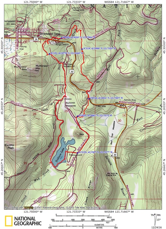
Trail Maps:
Topo Map, Download Garmin .gpx file
Length and Elevation:
8.5 miles roundtrip. Elevation at the trailhead is 3,790 feet. Total gain is 2,300 feet and loss is 2,300 feet. Highest elevation is 4,210 feet and the lowest elevation is 3,601 feet.
Review: 12/18/2016
From the Trillium Lake snopark decide if you want to break trail or follow the crowds. To follow the crowds, walk from the head of the parking lot down the snow-covered forest road. This hike breaks trail or you may find a track or two. Pick a place to walk west about 100 feet, then head south for 0.1 mile. Turn some to the right (southwest) and walk for about .25 mile where you should intersect Red Top Meadow trail. The forest opens up a bit and heads west for about 0.1 mile where it joins the main trail to Trillium Lake. This is Forest Road 2656 in the summer. Follow the tracked road for about .9 mile and turn right at the entrance to the Trillium Lake campground.
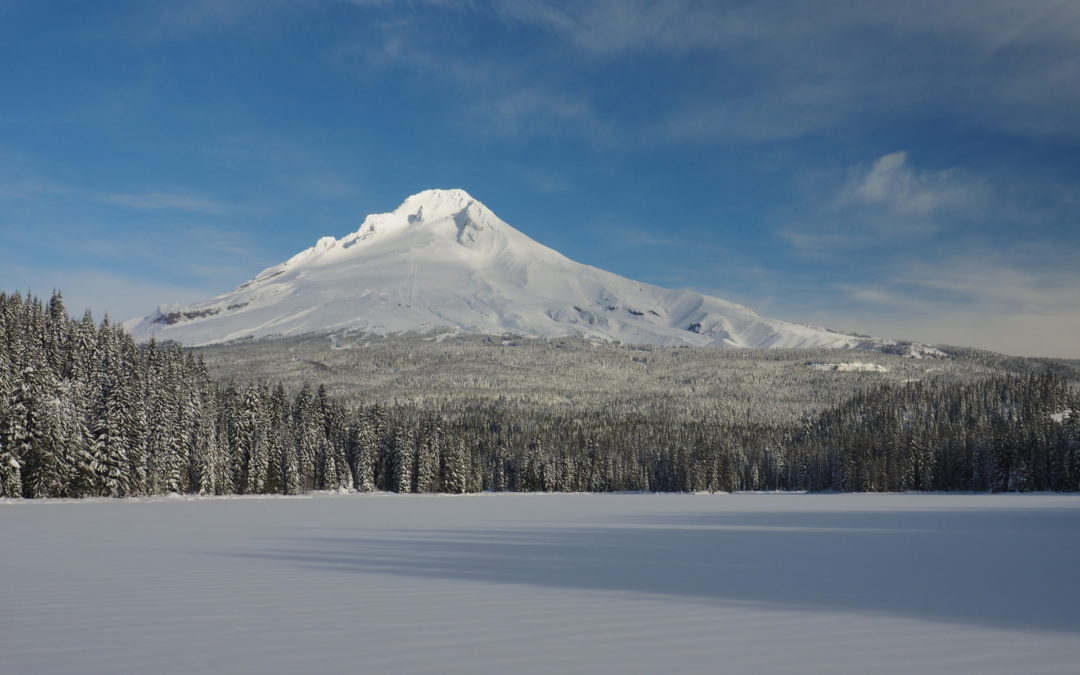
Walk through the deserted campground to the lake where you may find snow campers. Turn left to walk along the shore, or when the weather is cold enough, walk along the edge of the lake. On a clear day there are nice views of Mt. Hood all along the eastern shore. The path ducks into the trees and comes out at the man-made dam. Turn right and walk along the dam enjoying classic views of Mt. Hood. The popular track heads back into the trees and gently crests a small rise then drops down and passes by the north end of the lake. The trail passes by some rental cabins, and turn left at the power line, which will follow East Perry Vickars Road. Walk out into the meadow a bit to see where pioneer settlers stopped here to get grass for their cattle before they had to go over Laurel Hill. From the meadow there are partial views of Mt. Hood rising above the Douglas Fir trees.
Follow East Perry Vickars Road north over Still Creek and uphill to the junction with the Barlow Trail and a connector trail at about 5 miles from the trailhead. Turn turn left at the sign that says To Summit Trail and follow the short connector trail about 250 feet then turn right at the power lines and head uphill to Barlow Snopark.
Check out the Forest Service cabins at Barlow Snopark then turn left and cross Highway 26 at the beginning of Summit Snopark. Walk up Rd 530 for about 100 feet and turn right on West Leg Road. Follow the road, then walk through the woods to the Timberline Road. Cross the road climb up the snow berm and walk uphill for between 200 and 300 feet, looking for the blue diamond trail signs off in the trees. The diamonds may be hard to spot in the trees but they are before stop sign where Road 530 meets the Timberline Hwy.
The blue diamonds near the road were hard to spot but eventually they could be seen. This is the start of the Yellowjacket Trail, a rarely used trail marked with double diamonds on the trees. Once spotted they are reasonably easy to spot.
It’s not a straight trail and it crosses some tiny streams as it drops down to Still Creek. There is a small bridge over the creek but if the bridge is washed out you’ll have to take a couple of steps in the stream, avoiding the deeper spots, to cross the creek. Many spots in the creek are 4” to 6” deep.
After crossing the main fork of Still Creek, the trail turns sharply right to follow the creek downstream about 200 feet and then makes a hairpin around the ridge along the creek. There is an old bridge crossing over another small creek as you head uphill then turn to the right, following the blue diamond markers. There is a spot where a couple of big trees have fallen across the trail and you have to route find around the mess. Having to cross another couple of small stream adds to the challenge.
Follow the markers through the trees and the trees will thin and there will be nice views to the south. About 0.5 mile from Still Creek is a junction with an old road. Follow the roadbed downhill past a junction to the Yellowjacket Ski Trail East Leg Tie Trail ¾ mile. trail to the junction with Timberline East Leg road. Turn right and continue downhill for about .25 mile past the sledding hill to Snow Bunny Snopark.
The Yellowjacket portion of this trail is best if not hiked solo due to deep snow holes over the streams.
Enjoy the photos!!
Gallery Pics
Switchback Steve
Recent Comments