


Directions:
From Portland take I-84 East to the Wood Village, exit (16A). Head south and turn left onto NE Burnside Rd. Heading East, Burnside will merge into Highway 26. Follow Hwy 26 past Government Camp and exit on Highway 35 to Hood River. Follow Hwy 35 for about 2.7 miles. Turn right into the Barlow Pass Snow Park.
A Snow Park permit is required during the snow season. No permit is needed in the summer months.
No outhouses are available at the parking lot. The closest bathrooms are at White River West parking lot or Government Camp.
Length and Elevation:
Trailhead Elevation: 4150 feet.
Bushwhack Route to Lower Twin Lake: 5 miles roundtrip, elevation gain is 1,037 feet and loss is 995 feet. High point is 4,930 feet and the low point is 4,070 feet.
Pacific Crest Trail and Tri-County Butte Route to Lower Twin Lake: 4.6 miles roundtrip, elevation gain is 943 feet and loss is 910 feet. High point is 4,930 feet and low point 4,185 feet.
Return from Lower Twin Lake to Barlow Pass Trailhead on the Pacific Crest Trail: 4.5 miles roundtrip, elevation gain is 575 feet and loss is 622 feet.
Trail:
Pacific Crest Trail #2000, Twin Lakes Trail #495, Forest Service Road 3531 with connections to Palmateer Trail #482, Frog Lakes Trail #530, and Barlow Road.
There is at least one geocache along this trail at N 45° 14.688 W 121° 40.653. Info at Geocaching.com
Trail Maps:
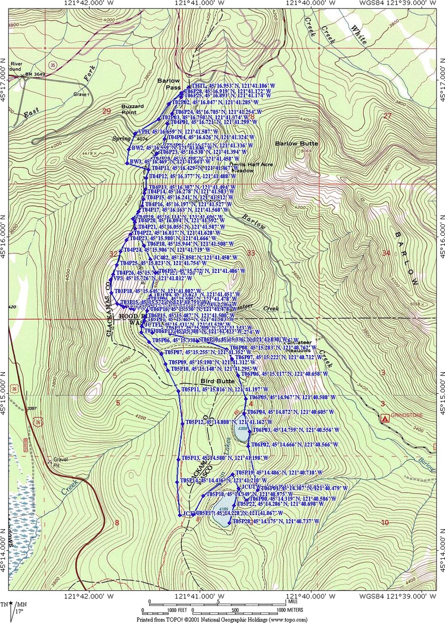
Topo Map, Download Garmin .gpx file
Review: February 6th, 2009
There are two starting choices for this trail, depending on snow conditions and your stamina.
The choice for when there is a lot of newly fallen snow is to start from the Barlow Pass trailhead on the east side of the parking lot and follow the Pacific Crest Trail southeast. The trail makes an almost immediate right from the trailhead and heads southeast. The first .5 mile of the trail is mostly level, gaining less than 200’. After that, the trail climbs moderately and has a few partial views of other ridges to the east but no views of Mt. Hood. Continue the gentle climb for the next .5 mile. From here you can branch off to the right of the Pacific Crest Trail and ascend another .5 mile to incredible views of Mt. Hood, or continue along the PCT towards Twin Lakes.
After the junction with the side-trail, the Pacific Crest Trail passes among the trees as it drops down to a junction for Trail 495.
The second option is when Mt. Hood is out and the snow is solid enough that off-trail snowshoeing is easy. For this alternate route proceed to the south end of the parking lot and follow the snow-covered Forest Road 3531 southeast, downhill. Following the Forest Road from Barlow Pass provides a nice view of Mt. Hood just where the snow-covered road makes a sharp turn to the right. This is where the bushwhack route starts, off the left side of the road at waypoint VPH, 45° 16.659’ N, 121° 41.587’ W. Hike up a draw looking for open areas, such as a small streambed, to snowshoe generally south to a small saddle. Turn left at BW3 and head east for about 750’ to intersect the Pacific Crest Trail. The open woods in this area make off-trail navigation easy, as long as you have a compass and/or GPS. Re-join the Pacific Crest Trail, which is just on the east side of the ridge that runs generally north-south. There are nice views of the ridge to the east and the forests blanketing the valley and ridge.
For either option of this trip, follow the Pacific Crest Trail for about .4 mile and there is a side-trail branching off to the right, climbing the north slope of the ridge you’ve been travelling along. This trail branches off the Pacific Crest trail near waypoint T04P21, 45° 16.055’ N, 121° 41.587’ and goes to VP3 45° 15.726’ N, 121° 41.812’ W. This side-trail climbs moderately except for one short, steep section where you should avoid the open slope in high avalanche times. The rest of this .5 mile side-trail to the promontory is quite safe with a moderate grade. The views of Mt. Hood from the promontory are perhaps the finest views of Mt. Hood in the area. There are also unobstructed views to the west and east. The open views to Mt. Jefferson in the south have a few trees in the field of vision, nicely framing the volcanic peak of Mt. Jefferson. The southeast route down from the promontory is steep in places but it is lightly forested which reduces avalanche danger. When the snow is unstable, avoid this steep slope by retracing your steps back to the Pacific Crest Trail.
From the junction of the side-trail and the Pacific Crest Trail, descend about 1.25 miles until the trail crosses a saddle and starts gently ascending the western side of Bird Butte. The trees are thicker here because they are on the western, wetter side of the slope. The trees on either side of the trail block any panoramic views here. The trail is very will marked with blue diamonds nailed to trees along the trail. One marker is usually within sight of the next and if you are the first on the trail, then you will be able to find your way with the waypoints and blue diamond trail markers.
The trail descends the last .4 mile before the junction to Trail #495, which leads to Lower Twin Lakes. At this trail junction, turn left and leave the Pacific Crest Trail. The trail to Twin Lakes drops down along the side of a ridge and through a very nice forest. The trees are all second growth trees and appear to be about 80 years old. The forested slopes are very green, bright, and open.
Arriving at Lower Twin Lake, feel free to walk to the south end of the lake and admire the fine setting with the green forest and blue sky as a backdrop. This is a fine place to have lunch and it is easy to find an uncrowded spot along the lake.
Travelling just past the northeast end of Lower Twin Lake is the junction to Upper Twin Lake. The trail almost reverses as it climbs southeast around the edge of a ridge. The trail switches back as it climbs around the end of the ridge and turns north, towards Upper Twin Lake, about .4 mile away. Upper Twin Lake has a partial view of Mt. Hood rising in the background above Bird Butte. From there, you can walk along the lake and rejoin the trail which is just east of the lake. From the lake, the trail climbs to a low pass on the east side of Bird Butte Summit and then drops down into the open forested watershed for Palmateer Creek.
After passing the saddle below Bird Butte Summit, it is a mile to the junction where Twin Lakes Trail #495 re-joins with the Pacific Crest Trail. In about .5 mile is the junction for Palmateer Trail #482, which is another route to Upper Twin Lake. On the Pacific Crest Trail, travel generally north back to the Barlow Pass Trailhead.
The trail is well maintained and there shouldn’t be much deadfall or bowed trees to push past. The Pacific Crest and Twin Lakes Trails are safe for children of any age, as well as dogs that are adapted to the snow. The main trails are straight and level enough that skiing would be an excellent choice for navigating these trails.
Enjoy the photos!
Gallery Pics
Switchback Steve
Recent Comments