

Notice: 2/6/2026 – This trail is now closed. Wahclella Falls Trail suffered extensive damages during December 2025 storms. .
Vicinity Location:
35 miles east of Portland, Oregon in the Columbia River National Scenic Area.
Directions:
From Portland, Oregon, take I-84 east for about 40 miles and take exit #40 for Bonneville Dam. Follow the road to the right, down to the parking lot for the trailhead. There are 12 regular and 2 handicapped parking slots. More parking is available along the edge of the offramp and there is overflow parking about ¼ mile east at the Toothrock Trailhead.
From Hood River, Oregon, take I-84 west to exit #40, turn left, then turn right at the “T” to find the parking lot.
Length and Elevation:
Total length is 2.4 miles round trip. Elevation gain is 450 feet and 450 foot loss. Elevation at the trailhead is 75 feet, the high point is 375 feet.
Trail:
Wahclella Falls Trail #436 with connections to Trail #400.
There is a restroom seasonally available at the trailhead. The closest bathrooms with a flush toilet are at the Bonneville Dam fish hatchery.
A Northwest Forest Park permit is required to park at the trailhead. There should be a fee collection box for the $5 day use permit.
Trail Maps:
Topo Map
Review: April 8, 2008, March 22, 2014
Follow the trail up Tanner Creek on an access road and enjoy the stream as it rushes past the moss-covered rocks. In less than 1/4 mile you come to a small diversion dam which supplies the Bonneville fish hatchery with water. In the fall be sure to look for salmon in the river. The tread of this trail is pretty good and drains pretty well even in rainy weather. There are only a couple of muddy spots on the trail.
Just past the dam is a bridge that crosses right in front of a 50 foot waterfall called Munra Falls. This waterfall gushes and splashes on the bridge during spring runoff but only slides down the rocks later in the season.
The trail gains elevation fairly quickly to look down on the stream. In one place the trail ascends about 25 stairs. Just to the left is a little grotto where the kids have made a little rock cairn. Perhaps the children pretend wood fairies live there.
Continue up the stairs and look back for nice views of the Columbia River Gorge and the Tanner Creek Valley. At 7/10 of a mile is the junction for the loop that goes to the falls and back. Turn right so you have a better view of the falls as you walk around the loop.
The trail drops down several switchbacks and crosses a sturdy footbridge in the bottom of the canyon. Bridges this size and weight are usually brought in by helicopter. This bridge is high enough above the stream to be safe from flooding.
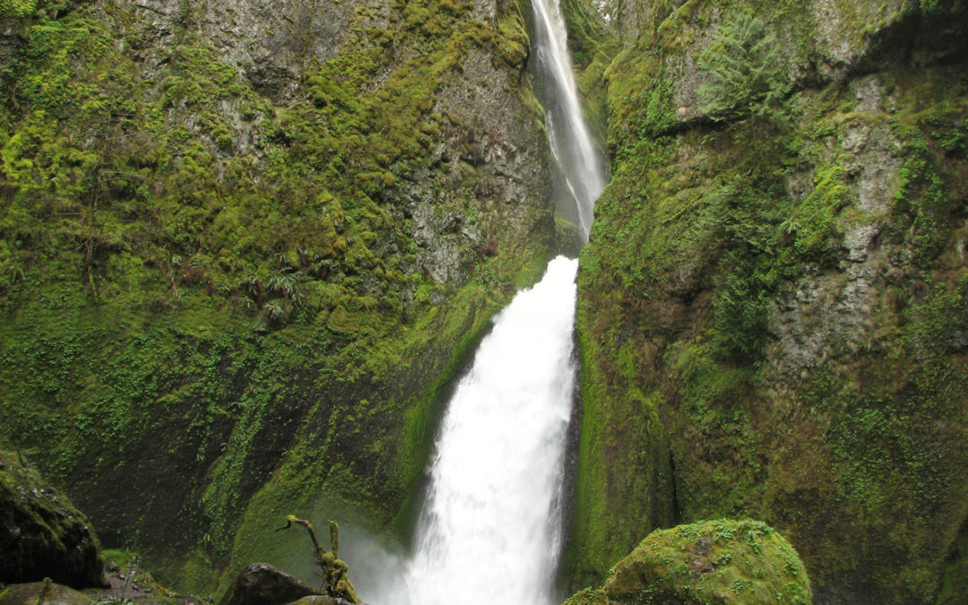
Walk a bit farther and enjoy the views of Wahclella Falls and a small waterfall on the west side of the canyon. Old guidebooks may call this Tanner Creek Falls, but it was renamed back to the correct name of Wahclella Falls by the Mazamas.
As you wind your way towards the falls, the trail passes under an overhanging rock with a small grotto with a small cave. I’m sure people have used this cave for centuries to get out of the weather. Imagine building a fire at the entrance to the cave to stay warm and to cook the salmon that were caught from Tanner Creek.
You will be impressed by the thundering falls and the way the water cascades out into a classic punchbowl fall. The whole area is covered by moss where the stream keeps the rocks wet all year. The stream gathers together and flows down the valley to the Columbia. The waterfall is 350’ tall and plunges down two falls. Native Americans have enjoyed this waterfall for centuries and you can understand why when you get to the falls. On sunny days in the early afternoon the first part of the falls are backlit by the sun.
The large moss-covered boulders that border the plunge pool are from a landslide in 1973. Enjoy the large cedar trees on the canyon floor near the falls. Climb on the trail and drop back down to the junction. Continue around the loop back to the junction and back to the trailhead.
This trail looks safe for children who have hiked before. There are some very steep hillsides and some small cliffs in a couple of places. As long as your kids are experienced hikers, I highly recommend this trail for the falls and the scenic canyon.
Enjoy the photos!!
Gallery Pics
Switchback Steve
Recent Comments