
Vicinity Location: The trailhead is about 50 miles southeast of Portland, Oregon in the Mt. Hood National Forest.
Directions: From Portland take I-84 East to the Wood Village, exit (16A). Head south and turn left onto NE Burnside Rd. Heading East, Burnside will merge into Highway 26. Follow Hwy 26 past Government Camp and exit on Highway 35 to Hood River. Follow Hwy 35 for 4.1 miles. Turn left into the White River West Sno-Park. If you cross over White River then you have driven too far.
In winter, it is required to carry chains or have traction devices.
The parking lot is a very popular location and can fill up on nice weekends.
There are pit toilets at the trailhead.
A current Sno-Park permit is required to be displayed between November 1 and April 30. Oregon permits cost $4 a day, $9 for three days or $25 for the season. The permits can be bought on-line, in Government Camp other outdoor stores or DMV offices.
Only attempt this route during moderate or low avalanche conditions. The steep slope at the head of the White River valley can be very dangerous. Understand how to evaluate avalanche conditions and when to stay off avalanche prone slopes.
You can see avalanche forecasts here: Northwest Avalanche Center
National Weather Service Snow Level forecast: Northern Oregon Cascades
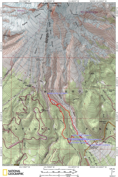
Trail Maps:
Topo Map, Download Garmin .gpx file
Length and Elevation:
6.2 miles roundtrip. Elevation at the trailhead is 4,235 feet. Total gain is 1,660 feet and loss is 1,660 feet. Highest elevation is 5,725 feet and the lowest elevation is 4,235 feet.
Review: 2/20/2016
From the parking lot walk towards White River and go upstream following the gated road. On a clear day you have unobstructed views of Mt. Hood as you walk up the White River valley. After about .25 mile, find a track or turn left and make your way to the crossing of Mineral Creek. The creek is tiny but the trail crossing is the best place to step over the creek. Upstream from the crossing the creek has carved a steep-sided gully.
Soon after crossing the creek there is a junction for the xx trail where you turn right and gain elevation fairly quickly. The trail turns to the left and after a short time, I found a good place to strike up the ridge.
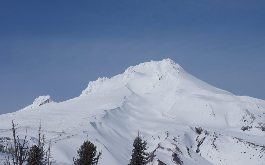
Breaking trail along the ridge isn’t too difficult as the ascent is moderate and there are openings among the trees to scout a path. After about a mile the trees thin out and then timberline is reached. The ridge flattens out and becomes less of a climb. There are just a few copses of trees and the views of Mt. Hood can be stunning as you see deep valleys rising up to the flanks of the mountain.
Snowshoe towards Timberline Lodge about another 0.5 mile and find a good spot to turn around, staying away from the steeper slopes of Mt. Hood. Head back towards the beginnings of the forest and cut left a bit to reach a very steep slope that drops down to White River. Use caution as you gauge the avalanche danger and if you believe the snow is stable enough, zigzag down the steep slope to White River or return back down the ridge.
Heading down White River is always a pleasant walk. There should be paths to follow but if not, it is easy to choose a route to stay on the bench above the river for about a mile. After that, you can drop down and follow the river pretty closely for the remaining distance.
The White River flows clear in the winter and if the sun is out, lends itself to great photo opportunities of Mt. Hood. The river never freezes in the winter and the snow can pile up high along the banks. The serpentine route provides many opportunities to see Mt. Hood as a backdrop beyond the river.
It is an easy walk downstream back to the parking lot.
Enjoy the photos!!
Gallery Pics
Switchback Steve
Recent Comments