

Vicinity Location: The trailhead is about 50 miles southeast of Portland, Oregon in the Mt. Hood National Forest.
Directions: From Portland take I-84 East to the Wood Village, exit (16A). Head south and turn left onto NE Burnside Rd. Heading East, Burnside will merge into Highway 26. Follow Hwy 26 past Government Camp and exit on Highway 35 to Hood River. Follow Hwy 35 for 4.1 miles. Turn left into the White River West Sno-Park. If you cross over White River then you have driven too far.
In winter, it is required to carry chains or have traction devices.
The parking lot is a very popular location and can fill up on nice weekends during the snow season.
There are pit toilet bathrooms at the White River Sno-park trailhead.
A current Sno-Park permit is required to be displayed between November 1 and April 30. Oregon permits cost $4 a day, $9 for three days or $25 for the season. The permits can be bought on-line, in Government Camp other outdoor stores or DMV offices.
National Weather Service Snow Level forecast: Northern Oregon Cascades
Length and Elevation:
13.6 miles roundtrip. Elevation loss of 1,481 feet and gain of 335 feet north to south. Elevation gain of 1,816 feet and loss of 1,816 feet roundtrip. Elevation at the northern trailhead is 4,272 feet and elevation at the southern trailhead is 3,123 feet.
Trail:
White River Trail #538 with connections to multiple trails
There are no geocaches along this trail.
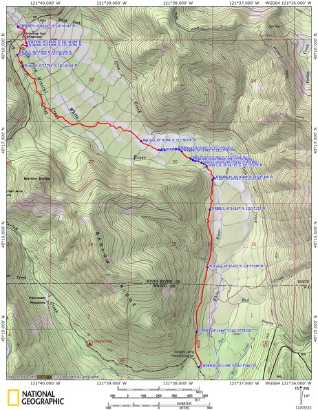
Trail Maps:
Topo Map, Download Garmin .gpx file, Open Garmin .gpx file
Review: November 3, 2023
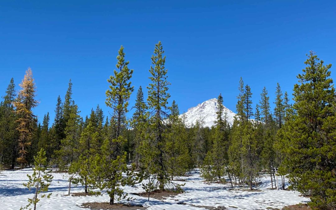
Start from the White River West sno-park on the east side of Mt. Hood. Make your way over the rocky glacial till outwash from when the White River floods. Most of the time the White River is about 15 to 20 feet wide but floods and glacial outbursts can swell the creek to uncrossable levels. At the present time the White River is in a channel on the far north side of the glacial riverbed and isn’t crossed for this trail however this may change some time in the future after the next major flood event. A short note is associated with many of the waypoints.
Cross under the highway bridge and start heading towards the larger, older pine trees which are about 40 feet tall. When you reach the trees follow their edge downstream for about 300 feet where you cut into the forest and follow a convenient gulley for about 400 feet where you should spot a firepit in a gulley at waypoint Wrmrk8. From here cross another small gully, make your way across a larger gulley, then look for the cut logs in a clearing through the trees. Follow this for several hundred feet where you look for the trail turning to the right to cross gully on a collapsed log and plank bridge. There is a safe crossing about 75 feet uphill from the bridge.
Now you should be able to follow the trail pretty easily for about the next mile. The trail goes gently downhill and you cross many step-over deadfall trees across the trail. The trail leaves the dense forest and at the next big gulley detour around the old crossing by looking for an opening in the brush just before the gully on the left and crossing the stream then follow the stream about 100 feet then look where the trail climbs the bank. In about another mile come to a brushy area. Here you can try to go around the brush by going to the left a bit and find a way that has been cut through the brush.
Back on the trail you enter a more open forest for about 0.2 mile before encountering another very brushy area. This area has some nice views of Mt. Hood. You’ll need to examine trees for cut branches that are almost grown over. There are places where a corridor cleared of trees and branches can be seen. The trail enters heavier forest again with brush and deadfall obscuring the trail.
Again, after about 0.4 mile the trail enters an open forest on sandy soil. After about 500 feet the trail takes a sharp right though there isn’t and immediate indication the trail has turned. After walking a couple hundred feet and entering a forest band you’ll see some cut logs to confirm you are on the trail.
Follow this to a wood 4×4 post stuck in the ground and find a place to wade across Mineral Creek. Once you find the trail on the other side of the creek the way should be plain. The nature of the trail completely changes and you walk through a mature forest with old growth trees and bridges over the streams.
After about 1 mile you come to the green metal roofed White River Hut which has not been used since the pandemic. From here walk down the old forest road to the Barlow Trail Road.
This trail has a couple hundred trees across the trail. The vast majority are lying on the ground and some you have to scoot over. Near the south end of the trail there is one massive old-growth tree across the trail and you have to detour through the forest a bit. There are several places where it is easier to go around the deadfall rather than over them. Expect to spend some time looking for the trail in several places. This trail is best hiked as a shuttle hike but you could use the Barlow Road to and forest roads to return to White River Sno-park. if backpacking this connects to several other trails.
Enjoy the photos!!
Gallery Pics
Switchback Steve
Recent Comments