

Vicinity Location:
The trailhead is about 43 miles West of Portland, OR, in the Tillamook State Forest.
Directions:
From Portland, take Highway 26 west for about 20 miles. Take the left exit for Hwy 6 towards Banks, Tillamook, and Forest Grove. This is also known as the Wilson River Highway.
Continue on Highway 6 for 29.3 miles from the junction Hwy 26 and Hwy 6 and make a right into the parking lot of the Tillamook State Forestry Center. The Tillamook Forestry Center is closed Monday and Tuesday.
Admission is free and cash donations are accepted. The hours in the summer are Wednesday – Sunday 10am – 4pm.
Check the website at http://www.tillamookforestcenter.org/ or call (866) 930-4646 to find out if the center is open during the winter months.
When the center is closed there is an alternate parking area at the Jones Creek Trailhead.
To park at the Jones Creek Trailhead, turn right about 28.5 miles from the junction of Hwy 6 and turn onto Jones Creek Road, travel about .25 miles and park in the gravel lot on the left.
No permits are required.
There are outhouses at this trailhead and at the Footbridge trailhead.
Length and Elevation:
3.5 Miles one way. Elevation gain 300 Feet and loss 440 feet to the turn-around point at Footbridge trailhead. Total gain and loss is 740 feet one way. Elevation at the trailhead at 530 feet, summit is at 650 feet. Lowest elevation is 390.
Trail:
Wilson River Trail – Jones Creek to Footbridge. Connections to Footbridge to Keenig Creek and Jones Creek to Elk Creek.
Trail conditions (sometimes out of date)
There is at least one geocache along this trail at: N 45° 35.029 W 123° 33.745 Info at Geocaching.com
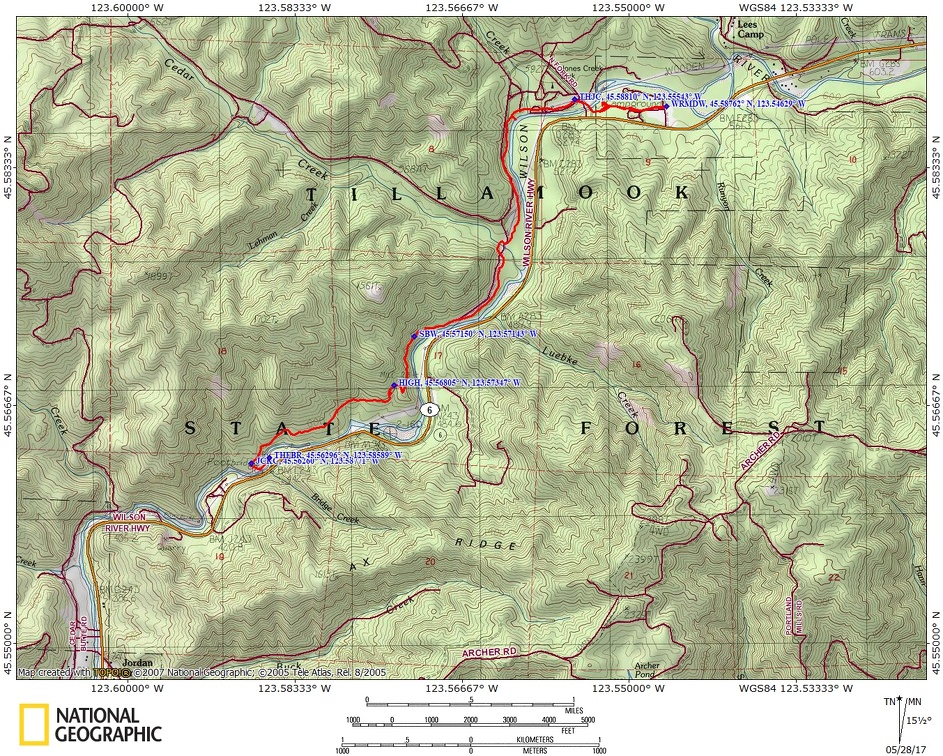
Trail Maps:
Topo Map, State of Oregon Map, Download Garmin .gpx file
History:
The Tillamook Burn is the name for a series of fires with the first, and largest fire, burning in 1933 and the last major fire in 1951, burning a combined total of 355,000 acres. The fires had a huge effect on the coastal communities of northwest Oregon.
The logging industry, which drove the local economies, was decimated. Much of the wildlife starved from habitat loss. Rivers took years to recover from the mud and debris that was washed down the barren slopes with each winter storm. The fire was so hot that the soil was sterilized, including tree seeds.
The firestorm pushed smoke and ashes 40,000 feet into the air and ash fell up to two feet deep in places along the northern Oregon coast and dusted the Willamette Valley. Charred fir needles fell 20 miles to the west in Tillamook.
The fire was so fierce that it was never contained and fall rains put out the fire in September of 1933. The first fire was the largest and burned over 270,000 acres. Later fires burned about another 80,000 acres. Most, if not all, of these fires were started by logging operations creating sparks in the forest. My mother remembers seeing the charred landscape and the pavement melted and burned up from the fire.
Most forest was privately owned at the time, but the fires burned so much timber that landowners couldn’t afford the taxes on the land and the cost of replanting so ownership reverted to the State of Oregon.
The Board of Forestry began the replanting effort and they got assistance from the Portland Public Schools and other organizations and businesses to arrange for school children and other volunteers to help replanting Douglas Fir trees.
From 1950 through 1970, more than 20,000 school children and other volunteers, such as the Boy Scouts of America and Girl Scouts of America, planted more than 750,000 trees in the Tillamook Forest.
A reforestation project of this size had never happened before. By 1970 over 72 million seedlings had been planted in what is now the Tillamook State Forest.
You can still see a few of the snags on the mountainsides near the summit of the Wilson River Highway but the rest of the forest is once again a sea of green.
Review: October 14, 2008
Make a trip to the Tillamook Forestry Center and see the exhibits about the Tillamook forest. There are lots of exhibits for children and several things for the adults to do.
Climb to the top of the fire lookout tower and see how forest fires were detected before the age of automation.
There are several picnic tables near the Jones Creek Trailhead. There is a water pump for the summer but the pump is locked up for the fall and winter. Jones Creek Trailhead parking is gated and closes at dusk.
The section of the trail from Jones Creek to the Forestry Center is a nice wide gravel trail. The road noise from the other side of the river mingles with the sounds of the Wilson River as you walk along the trail.
Watch out for stinging nettle along the trail between the Jones Creek Day Use Trailhead and the Tillamook Forestry Center.
After passing the suspension bridge to the Forestry Center, the trail gently undulates along the Wilson River then shares a gravel road for about 100 feet. The trail drops down off the road to the left, along the river, and follows near the banks of the river until switchbacking up to climb a ridge.
The trail comes out to a Forest Service Road. Walk along the road for about 100 feet, then look for the trail to drop down from the road on the left.
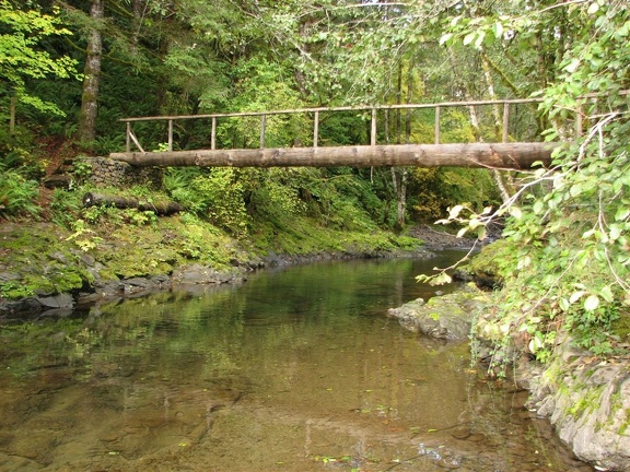
Cross under a powerline and after a bit of a rise you come to Cedar Creek. The bridge over the creek is a single log with a railing. The water is usually clear and it is a very picturesque setting. You may see salmon swimming in Cedar Creek in the fall.
The trail continues to parallel the river, then crosses back under the powerlines. This section of the trail has places that will probably be washed into the river during the next flood, so be sure to check the trail conditions before you hike this trail.
After about a mile the trail climbs some rocky switchbacks along the river and continues to climb through the trees.
The trail leaves the river and crosses a ridge. The trail drops down fairly steeply and comes back down to the river and reaches the Keenig Trail Junction. Turn left to reach the Footbridge Trailhead.
After the junction, the trail turns to the left, drops down, and crosses a flood channel of the Wilson River. Look across the flood channel and up to the right a bit for the continuation of the trail. The trail goes under the powerlines, climbs a bit under the powerlines to the top of a small hill, turns left, drops down, and crosses a sturdy footbridge across the Wilson River.
After crossing the Wilson River and arriving at the Footbridge Trailhead, you might want walk across the road and follow the short .25 mile trail and enjoy Bridge Creek Falls, a small waterfall on Bridge Creek.
Parking for the Footbridge Trailhead is about .1 mile to the east and has an outhouse adjacent to the parking area.
This is a good hike for a summer day when you want to swim in a river, or a cloudy or winter day when you want to hike through a forest of mixed evergreens and deciduous trees. The low elevation allows the trail to be snow-free almost all year.
This trail is not recommended for small children because there are some cliffs along the river and some dropoffs along the trail past the Forestry Center.
A good adventure for children would be to park at the Tillamook State Forestry Center and tour the center, then hike across the bridge over the Wilson River. From there, go to the right to the Jones Creek Trailhead and return to the Forestry Center. For a longer hike that is also safe for small children, turn left after the bridge and hike to where the trail meets the road and return.
Enjoy the Photos!
Gallery Pics
Switchback Steve
Recent Comments