
Vicinity Location: About 69 miles southeast of Seattle, WA in Mt. Rainier National Park.
Directions: From Seattle: Follow I-5 South for 25 miles and take exit 142A to merge onto WA Highway 18 East toward North Bend/Auburn. Drive 4.4 miles and take the Auburn Way/WA Highway 164 East exit toward Enumclaw for 0.2 mile. From Enumclaw, drive about 47 miles on Hwy 410 and continue south onto Hwy 123. In about 6 miles turn right and drive about 4 miles and take the first left after the tunnel, into the parking area.
From Portland: Take I-5 North towards Seattle and drive for about 75 miles. Take exit 68 for US-12 East. At the top of the off ramp, turn right onto US-12 and travel about 71.8 miles. This takes you past Morton and through Packwood. From Packwood, drive about 8 miles and turn north at the junction for Highway 123. Drive about 6 miles, past the Ohanapecosh Campground and turn left on Stevens Canyon Road. Drive about 4 miles and take the first left after the tunnel, into the parking area.
There are bathrooms and water at the trailhead until mid-October.
Pets are not allowed on the trails in National Parks.
National Park Entrance fee of $30.00 for a car or $25 for a motorcycle and a single passenger or Annual Pass is required to enter the park.
Length and Elevation:
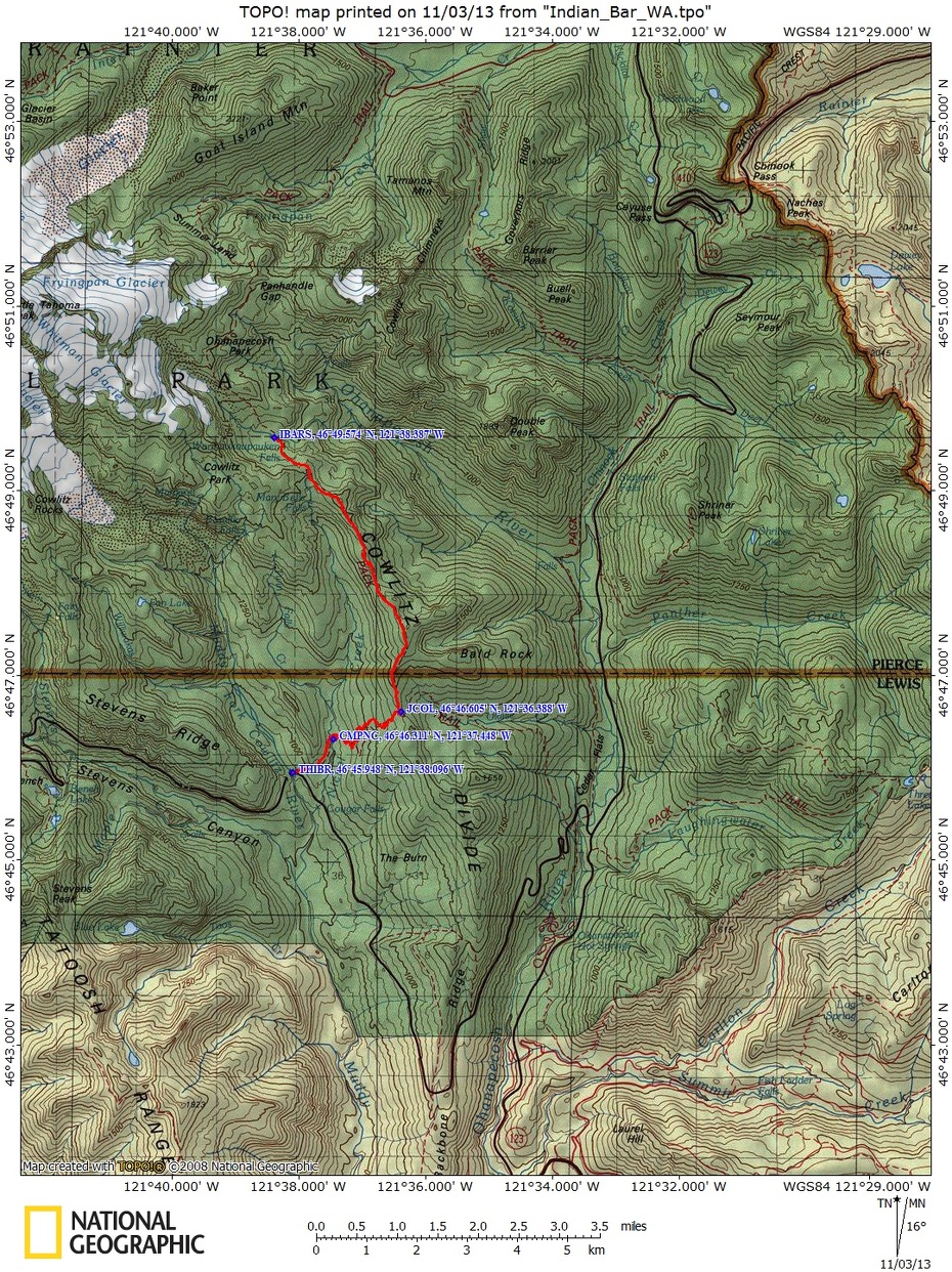
14.5 miles round trip. Elevation gain of 2,900 feet and loss of 800 feet. Elevation at the trailhead at 3,100 feet, highest point is at 5,914 feet. Lowest elevation is 3,100 feet.
Trail:
Wonderland Trail with connection to Box Canyon Trail.
Trail Maps: Topo Map, Download Garmin.gpx file
Review: October 26, 2013.
From the parking lot, walk across the street and look for the brown Wonderland Trail sign. Follow the skimpy trail over glacially scraped rocks to a sketchy trail junction and turn right. If you miss the junction you will walk onto the trail around Box Canyon after a couple hundred feet.
From the junction, the trail gently ascends through an semi-open forest with an understory of Alder and Vine Maples. In the fall there are many kinds of mushrooms and conks in the forest and the leaves are artfully strewn along the trail. In about .8 mile from the trailhead, gently descend down to Nickel Creek and cross on a single-log footbridge. About .1 mile from the creek you will pass the junction to the backcountry campsites of Nickel Creek. There is a group site and a few individual sites, along with a toilet within the sound of the creek.
From the camp, you enter a darker forest of fir and hemlock, walking about .2 mile before beginning a long, steady ascent up the side of Cowlitz Divide. Follow the trail up many switchbacks, sometimes in the silent forest, sometimes near a rushing creek, until leveling out after climbing for about an hour.
Still in the trees, you’ll pass the junction that drops down to Olallie Camp and eventually to Ohanapecosh Campground. You’ll probably see elk and bear scat in the trail and look for elk rubbings, which are where the elk have shredded the bark off little trees while rubbing the velvet off their antlers. I saw three saplings with the bark rubbed off on this trip.
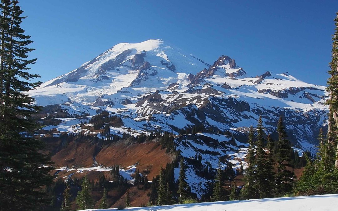
It isn’t long before the climb begins again in earnest. The rutted trail shows the effects of years of inadequate trail maintenance but thankfully isn’t usually very muddy. After navigating a few more switchbacks you’ll walk across a mountain meadow with nice views to the southeast. From here the views improve as the increased elevation travels into an alpine environment. Take a well deserved break at the first great view of Mt. Rainier along the trail. Hopefully you have chosen this trail on a relatively clear day.
Continue along the ridge, enjoying views of Mt. Adams to the southeast and Goat Rocks to the east. The trail dips and climbs as it generally follows the ridgeline for the next few miles. The philosophy of the Wonderland Trail builders was that climb every promontory to get another view of Mt. Rainier. And what spectacular views they can be. Since this is the east side of the Mountain, the sun shines at a nice angle on Mt. Rainier for most of the day, highlighting the Cowlitz glacier and Little Tahoma.
Of course nearly all views of Mt. Rainier are spectacular, there are some particularly fine views as the ground drops away from you, only to steeply rise on the flanks of Mt. Rainer, rising to the eternal snows of the summit.
After a few miles, the you pass the high point of this hike, drop down and cross a small saddle, then climb again. The trail deceptively climbs several high points. Each knoll tantalizing you into thinking it is the high point. To the northeast Twin Peaks and the Cowlitz Chimneys come into view to the northeast. The location of Panhandle Gap, the highest point on the Wonderland Trail, can be guessed by looking at a northern spine of Mt. Rainier and looking where there is a divot in the spine in the far distance. In the summer and early fall, this is about the summer snow line at 7,200 feet. By now you can see a valley carved into the slopes of Mt. Rainer. This is where Ohanapecosh River flows from the Ohanapecosh Glacier and has created Indian Bar. Indian Bar is a large, sloping gravel bar and ends in a narrow chasm crossed by a wooden footbridge. The shelter at Indian Bar is right where the gravel bar comes to a point.
Now the trail starts dropping, going through a small gully, through small groves of trees, and turning to the left, At first the trail drops at a moderate grade but soon steepens the decent with a series of wooden check steps. The trail passes through groves of trees and descending along a small stream towards Indian Bar. The view of the summit is hidden in the valley, but there are some rugged vistas at the head of the valley.
Drop down along a small stream and you will see the shelter on the left. Walk along a small creek for a bit, then step across the creek to arrive at the shelter.
The valley upstream is broad and green with a dozen waterfalls cascading down. Just below the shelter the Ohanapecosh River is squeezed into a tiny canyon and over Wauhaukaupauken Falls, then flows rapidly away down the mountain.
We hiked this in the fall, but in July the flowers are spectacular along the divide. From the shelter, it is easy to walk upstream and explore the area, perhaps enjoying mountain reflections in still pools along the river.
The shelter is home to several kinds of wildlife as you will soon find if you leave any food unprotected. You may be amazed how quickly they can chew through a pocket on your pack to get at some tasty treat. In the shelter many people have left their names or initials carved into the wood. It is vandalism but at the same time, it is interesting. As you probably guessed, the shelter was built by the Civilian Conservation Corps. Since its construction in 1940, it has had some lapses in repair attested to the green algae stains on the fireplace. Some new log posts and roof repairs are keeping it all dry at the present time.
Above the shelter at Indian Bar there is an open-air toilet that is not for the bashful kind. There are individual campsites across the river and through the woods.
When it is time to head back, it feels like a long climb out of the valley and along the small stream but soon the mountain views make it all worthwhile. Once back in the forest, the rest of the trip is mostly downhill. After crossing Nickel Creek, it seems too short of a time before the traffic noise intrudes and the parking lot comes into view.
This is one of my favorite longer day trips in the park with wonderful views of Mt. Rainier and the east side of the park.
Enjoy the Photos!
Gallery Pics
Switchback Steve
Recent Comments