
Vicinity Location:
About 42 miles northeast of Portland, OR in the Gifford Pinchot National Forest.
Directions:
From Portland, Oregon, there are two ways to drive to the trailhead. If you have an extra 30 minutes then make your trip a loop drive. For the loop drive, take I-205 north across the Columbia River. Exit I-205 on HWY 14 east for about 28 miles through the town of Stevenson.
For the non-loop option, take I-84 east from Portland and take exit #44 for Cascade Locks. Take the first right turn, just after you go under the Bridge of the Gods. Pay the $2.00 toll, cross the bridge, and turn right onto HWY 14 and drive 2.5 miles to Stevenson.
Once you get to Stevenson, drive about 2 more miles east to Wind River Road. Wind River Road is 5.9 miles east of the Bridge of the Gods. Drive on the Wind River Road for 8.6 miles to the community of Stabler. Turn left onto Hemlock Road and drive 1.3 miles.
From Hemlock Creek Road, turn right onto Forest Road 43 and drive for 1.4 miles to the trailhead, which is where the PCT crosses Forest Road 43, and park at a wide spot in the road. There is only room to park 4 cars here, but the road isn’t busy.
You can tell the trailhead location because there is an arched footbridge that crosses Trout Creek. There is also a Pacific Crest Trail sign just to the left of the bridge, posted in a tree. The Bunker Hill trailhead is just across the road from the footbridge, on the east side of the road.
The alternative it to take FR 43 from Hemlock Road for .6 mile and turn right on Forest Road 417. Follow FR 417 for .1 mile and look for a place to park. There isn’t much room to park. The trailhead is just past the bend in the road and is unsigned.
To return, take HWY 14 west back through Stevenson, and after about 2.5 miles, turn left and cross the Columbia River at the Bridge of the Gods. The toll for cars to cross the bridge is $2.00.
After the bridge, the road loops around and intersects Hwy 30, Cascade Locks Hwy, near the base of the bridge. Turn left here and you will merge onto I-84 west in about ½ mile. Follow I-84 west, back to Portland.
No permits are required at this trailhead.
No bathrooms are available at the trailhead.
Length and Elevation:
5.6 miles roundtrip from the Forest Road 43 trailhead. 3.8 miles roundtrip from the Forest Road 417 trailhead. Elevation gain 1,200 Feet and loss 80 feet to the summit. Total gain and loss is 2,560 Feet. Elevation at the Forest Road 43 trailhead is 1,190 feet, the summit elevation is 2,385 feet.
Trail:
Pacific Crest Trail #2000, Bunker Hill Trail #145.
There are no geocaches along this trail.
Trail Maps:
Topo Map, Download Garmin .gpx file
Review: February 21, 2010
The way for this trail is off to the east, away from Trout Creek. The trail heads east across the Wind River Valley. The first portion of the trail is flat, remember that bicycles are not allowed on the Pacific Crest Trail. The forest floor is carpeted with Oregon Grape, Salal, and mosses. Off to the left you can see parts of the Wind River Research Facility.
Forest research still occurs in the area. Nearby is the Canopy Crane. The crane allows forest researchers to be carried up into the canopy of the trees to study forest activities at treetop level.
After walking about .25 mile, the trail crosses a small stream. In the distance are buildings from the now decommissioned research facility.
About .5 mile along the trail is a small patch of rhododendrons growing on the forest floor. Be sure to look for the bright pink blooms in the spring.
The PCT comes out on a Forest Road 417. Make a left and walk on the road for 45 paces, looking for the trail to leave the road on the left. The trail parallels the road for less than .1 mile, then crosses the road into a large meadow. You can see Bunker Hill a short distance away, across the meadow.
The trail heads directly towards Bunker Hill, which is the forested mound straight off to the right from the road. Late winter brings seasonal streams which flow over the trail so be prepared to have waterproof shoes for winter and spring hikes.
The trail starts climbing up the side of Bunker Hill. There is a junction with the Bunker Hill Trail and the Pacific Crest Trail about 1.25 miles from the trailhead. The Bunker Hill Trail is unsigned and goes uphill to the left. There are 11 long, fairly steep switchbacks to the top.
On the way up is a rock ridge located at the 3rd switchback from the bottom. Scramble over to the rock ridge for great views. From this viewpoint you look into the Wind River Valley and the hills surrounding the Columbia River Gorge.
As the trail climbs beneath a canopy of Douglas Fir trees, you’ll start seeing some old growth trees about 800 feet from the top of Bunker Hill. The trees are about 4 to 5 feet across.
The forested trail continues up the side of Bunker Hill, passing a few moss covered rocks. Finally the trail reaches the top, and just a little farther the north is the site of an old fire lookout. Only the footings of the fire lookout remain. Trees have grown to cover the top of the ridge and obscure the view.
At the south end of Bunker Hill there are limited views of Mt. Defiance on the Oregon side of the Columbia River. Bunker Hill is more of a ridge than a hill and there are few views along the trail.
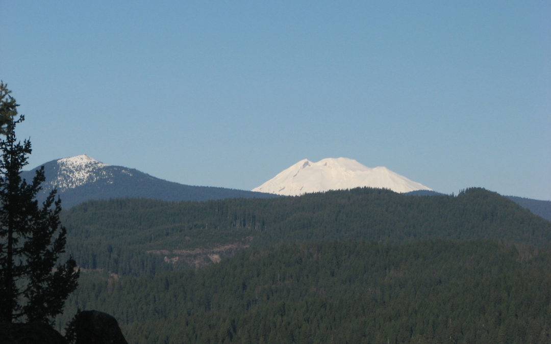
At the last switchback before the top is a barely discernible trail that goes straight ahead and the switchback goes off to the left. Following the waytrail it leads to a promontory with a great view of Mt. Adams and Mt. Hood. This is a scramble out to a rock thumb.
On the way back you can tell you’re getting close to the trailhead because the sounds of Trout Creek grow from a small whisper to a lout, rushing stream.
On the way back, enjoy the walk back through the tranquil woods, passing a couple of burbling brooks.
This trail not recommended for small children because of all the elevation gain and they definitely shouldn’t go out on the viewpoints.
Enjoy the photos!!
Gallery Pics
Switchback Steve
Recent Comments