
Note: 12/01/2020: The Road to trailhead is gated closed during the winter from Dec. 1st through March 31st. The gate is located 2 miles before the trailhead. For current information, contact Mt. Adams Ranger District (509) 395-3402.
Vicinity Location:
The trailhead is about 44 miles northeast of Portland, Oregon in the Gifford Pinchot National Forest.
Directions:
From Portland, Oregon, there are two ways to drive to the
trailhead. If you have an extra 30 minutes then make your trip a loop drive.
For the loop drive, take I-205 north across the Columbia River. Exit I-205 on HWY 14 east for about 28 miles through the town of Stevenson.
For the non-loop option, take I-84 east from Portland and take exit #44 for Cascade Locks.
Take the first right turn, just after you go under the Bridge of the Gods. Pay
the $2.00 toll, cross the bridge, and turn right onto Highway 14 and drive 2.5 miles to Stevenson.
Once you get to Stevenson, drive about 2 more miles east to Wind River Road. Wind River Road is 5.9 miles east of the Bridge of the Gods. Drive
on the Wind River Road for 16.5 miles. You will pass through the community
of Stabler and turning right just after the fish hatchery at Milepost 14.38.
Drive .8 mile and turn right on FR3062. There is a
brown road sign for Falls Creek. On FR3062, drive for 1.9 miles and continue straight for another .9 mile to the junction of FR3062 and 057.
For Trail 152A, turn right onto road 057. You will arrive at the trailhead for
trail 152A in .4 mile.
For Trail 152, continue straight for .3 mile and arrive at the trailhead.
Note: Forest Road 3062 is closed at mile .2 between
December 1st through April 1st.
To return, take Highway 14 west back through Stevenson, and after about 2.5 miles, turn left and cross the Columbia River at the Bridge of the Gods. The toll for cars to cross the bridge is $2.00.
After the bridge, the road loops around and intersects Hwy 30, Cascade Locks
Hwy, near the base of the bridge. Turn left here and you will merge onto I-84
west in about ½ mile. Follow I-84 west, back to Portland.
A Northwest Forest Permit or equivalent is required to park at this trailhead.
Bathrooms are available seasonally at the trailhead for Trail 152A. No
bathrooms are at the trailhead for Trail 152.
Length and Elevation:
Trail #152A: 3.4 miles roundtrip. Elevation gain 700 feet and loss of 95 feet to the falls. Total gain and loss is 1,590 feet. Elevation at the trailhead is 1,420 feet, the falls are at 2120 feet.
Trail #152: 4.4 miles roundtrip. Elevation gain 760 feet and loss of 100 feet to the falls. Total gain and loss is 1,720 feet. Elevation at the trailhead is 1,360 feet, the falls are at 2,120 feet.
Trails:
Falls Creek Trail #152, Falls Creek Trail #152A.
There is at least one geocache for this trail at: N 45° 54.636 W 121° 54.837 Info at
Geocaching.com.
Trail Maps:
Topo Map, Download Garmin .gpx file
Review: October 9, 2011
From the Trailhead for Trail #152 hike upstream along Falls Creek. After walking about 200 feet, there is a bridge over Falls Creek.
There are some nice views of the creek from the bridge.
Return to the trail and continue walking upstream, enjoying the sounds of the
creek and the pleasant forest. After about .5 mile you reach the junction of Trail 152A.
Continue walking upstream, straight ahead.
From Trailhead 152A, walk along the wide trail a short distance to the junction
for Trail 152, which is on your left.
Just near the junction is a place where you can walk down to the creek for
tranquil views of the stream. The trees lean out over the quiet water and the
rapids in the distance nicely accent the mossy rocks.
For the distances from Trailhead 152, add .4 mile.
From the junction of trails 152 and 152A, the trail parallels the creek about 30 feet above the streambed. There are places
along the stream where people have walked to the edge to look into the shallow canyon.
After .3 mile from the junction the trail comes to a
suspension bridge over the creek. The bridge is suspended on thick cables
anchored into the rocks along the stream. There are nice views of the creek
from the middle of the bridge and the short span is pretty stable.
The trail continues a gentle ascent along the north bank of the stream and
there are very nice views of the creek. The trail starts climbing a little more
steeply near the falls and there are some places where the trail narrows and
slopes towards a dropoff next to the trail.
Coming around a corner the upper third of the falls comes into view and it is
interesting to notice how the view of the falls changes as you approach the
falls.
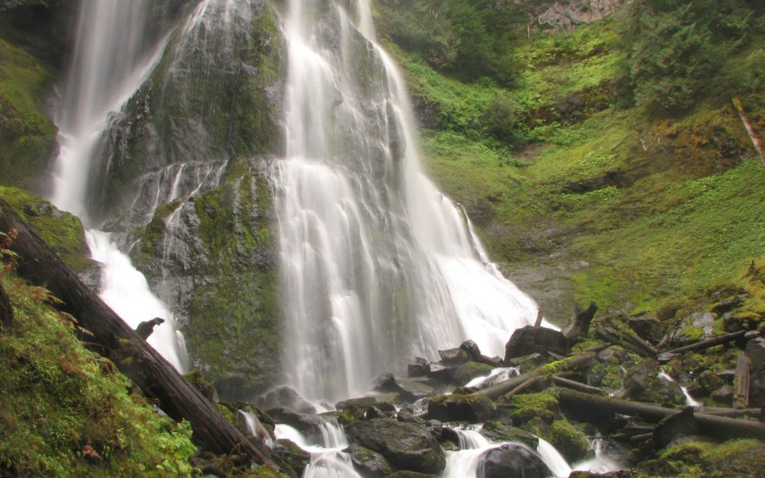
The trail comes to a viewpoint overlooking the lower part of the falls. The middle
part of the falls looks very different than the lower tier of the falls. The
lower falls is a plunge into a pool and the upper tier cascades down a rocky
cliff. The falls totals 250 feet tall and a pretty good amount of water
flows over the falls during the fall, winter, and spring.
For the more adventurous you can find a narrow waytrail that leads up from the
viewpoint, over a couple of logs, and along a precipitous trail that leads to
the base of the middle part of the falls. A slip on this narrow trail means a
tumble into the creek and a good possibility of being swept over the falls to
your death. This section is definitely not for dogs. After saying that warning,
if you choose to clamber to the base of the middle falls, it is a sensual treat
of touch, sight, and sound. There is a good place to stand and admire the power
of these falls once you negotiate the narrow waytrail.
The maintained trail is a good trail for dogs and children. The trail from
trailhead 152 to the junction with trail 152A is about the same elevation as
the creek. After the junction it is advisable to keep dogs on a leash because
of the cliffs between the trail and the creek.
Enjoy the photos!!
Gallery Pics
Switchback Steve
Recent Comments