

Vicinity Location: The trailhead is about 7,300 miles southeast of Portland, Oregon in the Torres del Paine National Park, Chile.
Directions:
Two days of flying brought us to Punta Arenas. We stayed at a homestead style AirBNB between the airport and town. Cell service was good with free wi-fi at the airports. We flew on LATAM Airlines in South America and all the airplanes had USB ports in the backrests. I think sitting on the left side of the airplane from Santiago to Punta Arenas is the scenic side.
Permits are needed to camp. Some sites fill up as soon as reservations are available.
Bathrooms at each camp.
Length and Elevation:
Total 93 miles. Elevation at the trailhead at 200 feet, highest point is at 4,072 feet. Lowest elevation is sea level. Elevation gain 16,309ft / 4,971 meters, loss 16,309ft / 4,971 meters.
Trail:
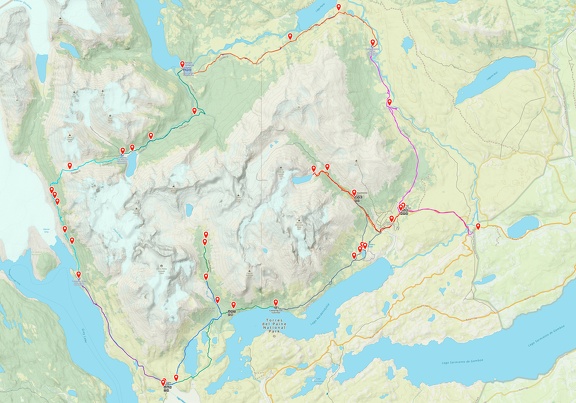
O-Circuit (also known as the Paine Circuit or Full Circuit), Pack Trail
We took a taxi to Bus Sur downtown and got into our assigned seats on the bus to Puerto Natales, which left right on time.
The first stop was the airport where we picked up a few people and then went on the 4 lane road along Straight of Magellan. Sitting on the right side of the bus allows for the best view of the water.
Bought most food at the Unimarc grocery store in Puenta Natalies. Many of the outdoor stores close for lunch and open again at 2:30. We had lunch at Espacio Ñandú.
Volkanica Outdoors for freeze dried meals but they were sold out when I checked – Puerto Natales
Wildland outfitters out of Flagstaff had a package for $2100 8 days with food and bedding.
Use Windgurú.com for weather forecasts
We met a woman from Germany hiking the O loop solo but starting from Paine Grande so she wouldn’t have to carry as much food over John Gardner Pass.
Length and Elevation:
Total distance is 93 miles. Trailhead elevation is 450. Highest point is 3,800 feet. Lowest point is 450 feet. Total ascent is 21,107 feet and total descent is 21,222 feet.
| Itinerary | Mileage | Camp Elevation | Ascent | Descent | Notes |
| Day 1 Camp Las Torres to Serón-Started 9:30 am – Finished at 2:30 pm | 10.3 | 600 | 1,876 | 1,760 | Dayhike to the river. |
| Day 2 Serón to Dickson-Started 8:40 am – Finished at 4:15 pm | 12.2 | 700 | 2,410 | 2,274 | Intense winds above Lago Paine possible. |
| Day 3 Dickson to Los Perros-Started 8:00 am – Finished at 2:40 pm | 8.7 | 1,900 | 2,342 | 1,187 | Need to cross dilapidated bridge. |
| Day 4 Los Perros to Grey-Started 7:00 am – Finished at 6:00 pm | 11.1 | 178 | 3,752 | 5,453 | Hardest stage of the O-circuit. Set out before sunrise. |
| Day 5 Grey to Paine Grande-Started 8:15 am – Finished at 1:00 pm | 7.7 | 5,160 | 2,827 | 2,693 | O-circuit meets W-trek: expect crowds. |
| Day 6 Paine Grande to Frances-Started 8:15 am – Finished at 12:30 pm | 6.5 | 625 | 2,000 | 1,293 | Pass through Refugio Italiano |
| Day 7 Frances to Los Cuernos-Started 8:00 am – Finished at 5:30 pm | 11.7 | 256 | 2,500 | 2,639 | Dayhikes to Valle Frances and Britanico Lookout |
| Day 8 Los Cuernos to Chileno-Started 8:00 am – Finished at 3:00 pm | 10 | 1,360 | 2,200 | 1,121 | No cook stoves allowed |
| Day 9 Chileno to Central Mountain Hostel-Started 4:30 am – Finished at 12:30 pm | 7.7 | 450 | 1,200 | 2,802 | Sunrise hike to Torres del Paine |
| Totals: | 78.2 | 21,107 | 21,107 |
Trails:
O-Circuit Trail, Pack Trail
Trail Maps:
Topo Map, Download Garmin .gpx file, Open Garmin .gpx file
Review: March 6, 2024
We were advised to find the longer horse trail at guardería lagoon pehoe and turn right off the main trail. It takes an hour longer.
Our water was turned off at night in the hostel.
I could not find any freeze dried dinners in Puerto Natales. Everyone was sold out. Also I couldn’t find a hard cheese like cheddar or Parmesan, only Emmental and Gouda.
The bus terminal was really crowded with many buses in the morning. With our advance tickets we found our bus outside and were checked in and found our assigned seats. This bus did not have USB ports so I was glad I had charged my phone the night before. The outlets in this part of Chile are two round prongs, type C, which might be the same as in England.
On the tour bus it looked like it said the bus toilet was for peeling only. The big tour bus takes you to some buildings where you show your pass with the QR code to check in and can go to the bathroom. The day we were there the bathrooms had no toilet paper.
After that you go to the line of smaller white tour vans and pay the driver to shuttle you to the drop off. In 2024 it cost 4,000 CLP or $5 American. The bus ride takes about ten minutes and drops you off at the bathrooms and where you can get coffee and snacks. From there you follow the path at the south end of the building to begin your trek.
Keep left of the cluster of buildings and you’ll see the signs pointing to Serón. Follow the jeep road as it switchbacks up the hill on the right. From there the trail is easy to follow.
The route varies between a jeep road and a trail. After some miles there is a trail along the river. A short side-trip takes you above some rapids and gives nice views of the river.
Eventually you get to Seròn. Here only the person who made the reservations needs to check in. There is food and beer that can be bought here.
From Serón walk along the river for a few miles then climb a ridge then drop down and follow the trail about 200 feet above the lake.
About a mile past the lake is a small stream for water and Coiròn, a good place to stop for lunch, and you have to check in here with the Ranger.
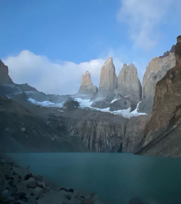
Continuing on there are great views of a glacier and rock spires across the valley. Walking through the valley meadows you pass through groves of trees.
Eventually you climb up to the top of a very large terminal moraine and descend very steeply down to Dickson Camp. Here everyone has to check in. Dickson provides free showers and pizza, burgers, beers, and a place to throw away your garbage.
This section of trail mostly goes through a nice forest. There are plenty of mosquitoes waiting for people to take a break. There is a nice viewpoint where you can take a break and a nice lunch spot just before the bridge over Rio Des les Perres River.
Near the end of the day begins a steep climb over an ancient glacial terminal moraine. There are some great views of the Glacier Olgin and there is a sheltered spot on the lakeshore that is nice to visit after checking in.
There is no Wi-fi here and you have to pack out your trash. Services and food here are very limited unless you have pre-purchased the meal package. The sound of the nearby river lulls you to sleep which is good because you have to get up extra early to get to the next camp.
We woke at 4am and departed at 6 am. We immediately started climbing up a steep, rooty hillside. We had to pay close attention to the markers and the flagging to stay on the trail. As we climbed the trail crossed mini wet areas which made mini mud bogs of the trail.
We continued climbing up through the forest along the mud pocked Trail. after an hour or so, the trail came out onto a long, scree slope going up the valley. The trail was a little bit here, at least along the rocks, but it would occasionally dip down to pass through small groves of trees.
The river on the right that comes out of John Gardner pass, rushed by as we climbed higher and higher up the steep trail. We were fortunate that there was no snow, but it was pretty windy. We climbed Higher and Higher along mountain rivulets, and the trail got steeper and steeper, and turned into more of a choice of tracks than a trail.
The trail that really steep as we got closer to the top and the wind blasted us continuously. Making it to the top we hardly paused so that we could get out of the past and to a place less dusty.
Going down the other side of John Gardner passed we looked out and could see a glacier far in the distance. Then I noticed that what I thought was perhaps a river or a bay was actually the gray glacier which looked to be more than a mile across. As we descended the steep trail we saw ever better views of the glacier.
This next section of trail was steep, and with giant steps and places to slip and fall. We dropped down into the forest, but the trail really didn’t get any better. Once the trail started to level out then, it would steeply rise and fall over different rock outcroppings.
There were places that had great views of the glacier. One was our lunch spot where a medium size stream went over a waterfall beside the trail. We stopped and had lunch here and enjoyed the fantastic view of the glacier. As we were watching rain in the distance, turned into a rainbow for a unique view of a rainbow over a glacier.
We continued along the difficult trail, climbing and descending, though we really didn’t change elevation much for the next few miles. There was a really difficult section where the trail is in poor shape as it deeply switchbacks up a rock promontory. If you were to fall off here, you would probably roll down into the lake and die. The trail involves crossing three fairly long suspension bridges even though the limit is four people at a time typically one person at a time crosses because it is so bouncy. If you are behind a group, it can take quite a while to cross the bridges. Eventually we made our way down to the well provision camp, and set up our tents. we were worried about the rain so we tried not to pick spots where water would puddle when it rained. The wind really picked up during the night and Sean had some tent problems. As for Pamela and myself, we were on a spot where the wind stirred up a lot of gritty dust and blew it into our tents. The next morning everything was coded with a thin layer of gritty dust in my tent.
we got ready the next morning and cook breakfast and just as we left the indoor cooking area opened up.
We went under high winds, high clouds, and occasional showers as we walked along Gray Lake. This section of trail was much more consistent in elevation change compared to trails of previous days. The mountains on both sides of the lake are very pretty and the trail is pretty easy. We got into camp around noon.
The wind had gusts to 50 mph as we set up tents. It appeared to be windier in the middle of the camping area compared to near the hill.
At Paine Grande you can usually rent a tent for $30 or if you set up yours then get as close to the hill as you can as it is less windy. Expect gusts of up to 40 MPH or more. These winds break poles in lightweight tents. Expect your tent stakes to get pulled out it they aren’t staked well. Also beware of setting up in areas without grass.
We left a little after 8 AM with light sprinkles. About a mile or so out of camp we have been told to take the pack trail instead of the regular trail. It takes an hour longer, but there are a few more people. Our map did not show the trail going through, but I was confident the trail would be a good route. It turns out this was one of the nicest sections of the whole trail. The trail has been well-maintained, and since it was not traveled much, the tread was in very very good shape. Also, it is a little bit away from the mountains, so it has a stunning view looking towards the mountains. the trail rows in a couple of miles before it rejoined the main trail. There were some boardwalks across Meadows that REI had helped build. we rejoined the main trail at a suspension bridge and crossed and had lunch. A short walk later we passed by the Italiano refuge, and then it was another mile and a half to our camp for the day. For most of the morning, the rain had come in short, light showers. the afternoon was sunnier, but the clouds hung around mountains all day.
Camp Francis is platform camping and the wood platforms are scattered along the forested hillside above current camp. We explored down at the old store and the hotel then took a shower and had a beer in the dining hall.
The next morning dawned bright and clear. We got up at 6 AM and left about 8 AM. We walked back to camp Italiano and took the trail up to Britannia viewpoint. A lot of the trail is very rocky and other parts are navigating boulders in the trail and steep sections where you have to pick your way up rocky slopes. The views were fantastic and there were ice falls from the glaciers about every 15 minutes.
We got up to the viewpoint and enjoyed stunning views of the mountain valley. Sheer cliffs led up to snow clad peaks. But the best was yet to come. From the viewpoint, we won another 2 1/2 miles up the valley to the end of the trail and fantastic viewpoint of a mountain pillar, sheer cliffs and majestic peaks. The sky was perfectly blue when we got there, and we stayed at the viewpoint for quite a while, taking big pictures and enjoying the views. As we had back down the sun filled the valley and made some nice views of the sunshine sparkling on the glacial stream, pouring out of the valley. as we descended further, we saw the clouds begin to move in first they were just high scattered thin clouds, but as the day were on the clouds became thicker.
We returned to camp and got organized and enjoyed the beer before hitting the trail to the next camping area. The trail climbed from our camp, then slowly descended, and went along the shore of a lake for a while. From there was just a short climb up to the nights camp. It is another platform camping area, but not nearly a steep of a slope as the night before.
Tent 18 for Pamela and Sylvia
Day 7 to Refugio Cheleno
We woke up at 6 AM again, and had the refugee breakfast at 7 AM. It was toast, eggs, cereal, yogurt, coffee, coffee, some meat, and some cheese. It cost about 15,000 pesos.
It was nice to have a breakfast fixed for us for a change. We got all packed and left at 8 AM. The walking was fairly easy for the first part, though there was a headland that we climbed over. It gave us great views of the lakes and the mountains around us and the trail was relatively level and we made good time.
We found a wonderful spot for lunch with 360° views of mountains and lakes. After lunch, we continued down the trail, then cut over to see the travelers waterfall. This turned out to be a mistake because we got off of the trail that we should’ve been on and we were heading towards the wrong Chilano Refugio. When we had almost arrived there, we realize we were going the wrong way then we had to backtrack about half of a mile and then climb climb climb.
Sylvia had gone ahead and when we arrived at our campsite she was not there. We got our tents set up on the platform and then saw Sylvia coming to camp while we were finishing getting our tents ready. She didn’t wait at the next trail junction for us and ended up walking all the way to the end of the trail and then back to us.
I went down towards the restaurant and saw that the pack horses were coming in, and I watched them unload supplies.
We gave Sylvia and Pamela the nice tent and we set up our tents on the platform and then went and had a beer in the pub.
After that, Sean and I took a hot shower, then came back to our tents to wait for dinner at 6:30 PM. There is no cooking in this campsite so you have to buy all the meals. We will have our breakfast ready for us when we leave at 4:30 AM tomorrow.
Torres del Paine day hike we got up at 3:30 AM. We had breakfast a little before 4 AM and we left about 4:15 AM. We arrived up there about 6:20 AM. The Torres del Paine are three granite peaks pillars of the Paine mountain range or Paine Massif. We left about 8 AM and arrive back down just before 10 AM. We went back down the trail and went to the Torres Central Hostel. They were at lunch when we arrived and check-in was at 2:20. Sean wanted to fully complete the “O” circuit so we shouldered our packs and walked to the Welcome Center. We found out there were only a few shuttles per day running to the park entrance. Shuttles from the visitors center to the Laguna Marga park entrance are at 8 am and 10:30.
We went back to the hostel and before check-in we were able to leave our packs in a storage room behind the check-in counter. At the Torres Central Hostel you can cook meals outside but we had bought dinner.
We discussed our options and decided to buy breakfast at 7 am and catch the 8am shuttle. We found out there were other shuttles too.
We checked in and the rooms have six bunk beds. I got a top bunk and there was a USB charging port.
We wandered around and took some pictures of Torres del Paine. Dinner took a long time and the salmon was good but they scorched the dessert pudding.
We went to bed and the snoring was loud so I tried to sleep in the common area but that was too loud from the noise from the restaurant.
I went back to the bunk and started some rainfall noise, put in my earbuds and went to sleep.
The next morning we got all our stuff together went to breakfast. The breakfast was quick and we started walking to the visitor center. On the way Pamela mentioned seeing a bright red Mountain Hardware sleeping bag in the common area and with a wave of dread I realized it was my bag and I had left it behind.
I dropped my pack and ran back and got my beg. Wow that was lucky Pamela mentioned the bag.
Sean and I bought a sandwich in the Welcome Center and we caught the shuttle with no problem. Back at the park entrance we had a two hour wait for our bus to Puerto Natales.
New 4 day hike near El Chalten is The Huemul is hiked counterclockwise. Has steam crossings using a cable.
We met Gruener and Ivanka along the way.
Bought 3 freeze dried meals for 38,000 pesos in Chile
Salami and half pound of snacks
We saw different equipment brands including several Doite tents and gear
Enjoy the photos!!
Gallery Pics
Switchback Steve
Recent Comments