
Vicinity Location:
The trailhead is about 42 miles northeast of Portland, Oregon in the Gifford Pinchot National Forest.
Directions:
From Portland, Oregon, there are two ways to drive to the trailhead. If you have an extra 30 minutes then make your trip a loop drive. For the loop drive, take I-205 north across the Columbia River. Exit I-205 on HWY 14 east for about 28 miles through the town of Stevenson.
For the non-loop option, take I-84 east from Portland and take exit #44 for Cascade Locks. Take the first right turn, just after you go under the Bridge of the Gods. Pay the $2.00 toll, cross the bridge, and turn right onto Highway 14 and drive 2.5 miles to Stevenson.
Once you get to Stevenson, drive about 2 more miles east to Wind River Road. Wind River Road is 5.9 miles east of the Bridge of the Gods.
Drive on the Wind River Road for 16.5 miles. You will pass through the community of Stabler and turning right just after the fish hatchery at Milepost 14.38. At about mile 16.5 from Highway 14, turn left onto Dry Creek Road #64.
From Dry Creek Road, pass through a green gate at .2 mile. At 1.7 miles, keep straight, don’t take the road on the right. At 3 miles continue straight on the paved road.
The pavement ends at 4.1 miles. Continue straight ahead.
At 6.1 miles, go straight past a 4-way junction. At 6.6 miles, keep left and pass a small road on the right. At 7.4 miles, keep left and pass a small road on right. At 7.9 miles, keep left. At 8.1 miles is the trailhead parking area on the left.
The last couple miles of the road has areas of potholes at wide spots in the road. In summary, once on Dry Creek Road, follow the most used road, taking the main road, always choosing the main road on the left.
To return, take Highway 14 west back through Stevenson, and after about 2.5 miles, turn left and cross the Columbia River at the Bridge of the Gods. The toll for cars to cross the bridge is $2.00.
After the bridge, the road loops around and intersects Hwy 30, Cascade Locks Hwy, near the base of the bridge. Turn left here and you will merge onto I-84 west in about ½ mile. Follow I-84 west, back to Portland.
No permits to park are required at this trailhead. A free Wilderness Permit is required to be filled at the permit box.
No bathrooms are available at the trailhead.
Length and Elevation:
6 miles roundtrip from. Elevation gain 1,030 feet and loss or 400 feet to the summit. Total gain and loss is 2,860 feet. Elevation at the trailhead is 3,540 feet, the summit elevation is 4,207 feet.
Trails:
Observation Peak Trail #132, Observation Peak #132A with connections to Big Hollow Trail #158, Trapper Creek Trail #192.1 and Shortcut Trail #132B.
There are no geocaches along this trail.
Trail Maps:
Topo Map, Download Garmin .gpx file
Review: October 8, 2011 – This trailhead is the northern end of the Observation Peak Trail. From the parking area, take the trail that leads uphill into the trees. The wilderness boundary is just up the trail and you are required to fill out a free Wilderness Permit form. The trail starts in a nice forest of Douglas Fir and Hemlock and continues to climb about a mile up to Sister Rocks. The trail passes through an older second-growth forest and the forest floor has and understory of Vine Maple, Mountain Ash, Huckleberries, Bunchberries, and other plants typical of the damp forests of the Northwest.
At Sister Rocks the trail starts to lose elevation. Just past Sister Rocks, look for a trail off to the left that goes to a nice view from the face of Sister Rocks.
After hiking about 1.75 miles you come to the junction of Big Hollow Trail and Berry Camp. If you want to camp, there is a spring just a few hundred feet down the Big Hollow Trail. Please be kind and bury any human waste and toilet paper or pack out the toilet paper.
From the camp, continue on the trail, passing the Trapper Creek Trail which goes off to the right. The tree canopy is thicker here and there is less undergrowth away from the trail. The trail begins climbing gently and comes to two trail junctions close together. The first is Shortcut Trail #132B, leading off to the right, and the second is a Y junction. At the Y, the left trail is the continuation of the Observation Peak trail and the right trail is the Observation Peak #132A.
Take the trail on the right and begin the climb up to Observation Peak. The trail ascends a couple of switchbacks and passes a waytrail on the left. The waytrail leads up to a rocky point with a 180 degree view towards the east.
The Observation Peak Trail then makes a steady climb to the top of Observation Peak. There are a couple of spots where the trail is fairly steep but the sections don’t last long.
This peak was the site of a fire lookout and you may find melted pieces of glass and other items from the old lookout. There are a couple of flat areas to camp but the closest water is near Berry Camp.
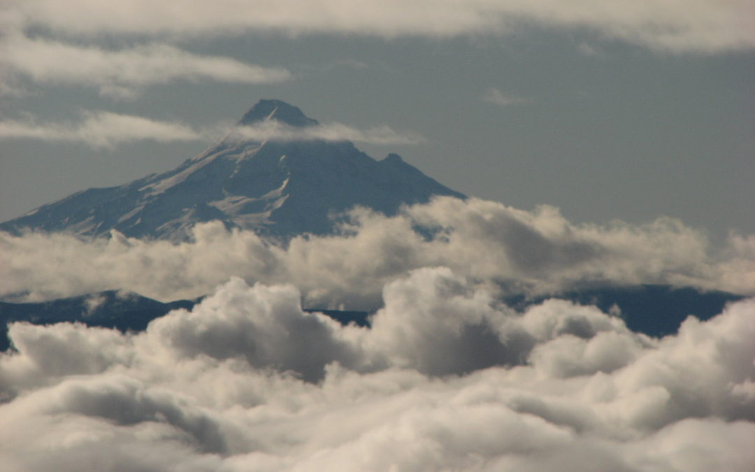
On Observation Peak you can see the Carson Fish Hatchery, Mt. Adams, Mt. Hood, Mount St. Helens, and Mt. Rainier. On very clear days you can see Mt. Baker to the north and Mt. Jefferson in the south.
Heading back down you might find some Huckleberries to snack on. Return the way you came, or you can combine this with other trails in the area to add a loop.
This is a good trail for dogs and children as the only cliffs are along user trails to viewpoints. This is an excellent trail for barefoot hiking because most of the trail is covered with fir needles. The only rocky part of the trail leads up to Observation Creek.
Enjoy the photos!!
Gallery Pics
Switchback Steve
Recent Comments