

Queens River Loop, Idaho – August 12th through August 17th, 2015
Vicinity Location: Sawtooth National Recreation Area
Location: The trailhead is 53 miles northeast of Boise, ID near the community Atlanta.
Directions: From I-84 in Boise, take exit 57 for Highway 21. Drive 12.8 miles northeast, passing the Lucky Peak Dam. Just after crossing over an arm of the Lucky Peak Reservoir, turn right onto Arrow Rock Road, following signs towards Atlanta and drive on pavement for 4 miles. Continue on the main road for another 63 miles past the reservoir, past Twin Springs, and along the Middle Fork of the Boise River to Queens River Campground. Turn left onto Forest Road 206 and drive for 1.8 miles then take the road to the left which leads to the Queens River Trailhead in .3 mile.
There is a pit toilet near the gravel parking lot and it looks like there were once water troughs for horses.
Trail conditions: Sawtooth National Recreation Area: 208-727-5000
Permits: Free Wilderness permit at the trailhead.
| Day | Started | Ended | Camp | Elevation | Gain | Loss | Miles |
| 1 | 10:30 | 8:10 | Scenic Lake | 8385 | 4200 | 1600 | 11.75 |
| 2 | 9:00 | 9:30 | Pat’s Lake | 8312 | 4300 | 4600 | 13.75 |
| 3 | 9:30 | 8:30 | Camp on Queens River | 6727 | 2900 | 4300 | 10.45 |
| 4 | 8:30 | 1:00 | Trailhead | 5285 | 900 | 2000 | 8.80 |
| Total | 12300 | 12500 | 44.75 |
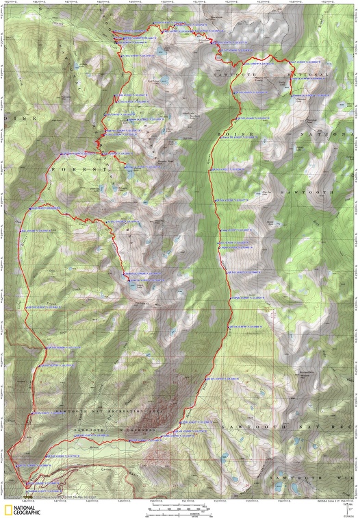
Trail Maps:
Topo Map, Download Garmin .gpx file
Review:
Sean and Larry were looking for a trip to Idaho and found this trip by looking through “Backpacking Idaho” by Douglas Lorain. Sean posted the trip on a Meetup group and Don and I joined the trip.
We met at Larry’s house and Sean drove us to Boise as we shared stories along the way. We found a traditional pizza place for dinner in Boise and stayed at a Best Western with free breakfast.
The next morning we met downstairs at 6 for a hot breakfast. I had eggs, sausage, and a Belgian waffle, the last nice meal for a while. We left the hotel at 7 am and headed out, eager to get hiking on this blue-sky day.
From Boise, we drove on Highway 21 to the Lucky Peak Reservoir and turned off the highway. From there we had 4 miles of pavement and about 64 miles along a road that is very narrow. After passing Arrowrock Dam, the narrow road skirted the reservoir and the steep slopes dropped a few hundred feet down to Arrowrock Lake were a little disconcerting with no guard rails to stop a plunge into the lake.
In places you can see big piles of river rock where dredges and Chinese laborers moved rocks to find gold. The road was quiet and we arrived at the trailhead and started our trip about 10:30. The trailhead has a toilet and signboard about the area.
We set out, crossing a bridge, turning left, and entering a burn zone. The severity of the Little Queens Forest Fire from August 2013 would vary for the next 1 ½ days from no damage to some burned trees, to a forest of blackened trunks both standing and strewn across the forest with all the organic matter in the soil burned away.
Following the Little Queens River upstream, the trees are mostly burned with grasses and Fireweed carpeting some areas. The trail stays pretty close to the river and we crossed Browns Creek easily and we could rock-hop across Little Queens River.
The trail is never very steep and we trudged along through the burn, two of us getting wet feet at one crossing and two choosing to wade at another crossing.
Shortly before we arrived at the junction for Scenic Lake, we passed the junction of Neinmeyer Trail and a nearly dried up beaver pond, the beavers gone. We took the junction to Scenic Lake, dropped into the burn, crossed a small creek, and started gently uphill.
We headed towards out campsite, climbing through a large meadow then onto some switchbacks which pass near a waterfall on Scenic Creek.
The trail builders must have been running out of time because the trail steepens and you need a lot of water as you slog up this open, steep slope. As with all trails, you eventually go over the rim of the slope and the grade moderates. Looking back you can see the valley and all the slopes burned by a very hot forest fire.
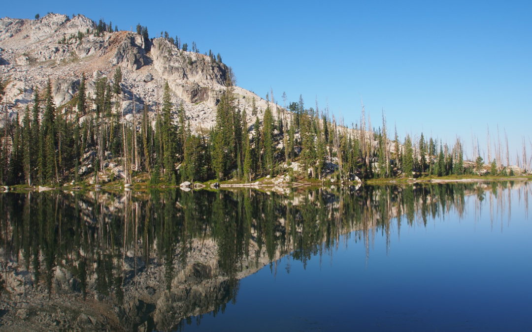
Continuing on through the burn you will have to route find carefully among the fallen trees. We lost the trail but saw it again when we were standing on rocks overlooking a large meadow. We could see the trail in the grass just on the left side of the stream. The trail goes along the meadow then goes right next to the stream through a gap in the rocks. The trail then climbs up to a small lake.To get to Scenic Lake, cross the outlet stream and make your way along the left shore for about 150 yards then climb steeply along the hillside to Scenic Lake. Take note of how you crested the hill because the trail isn’t distinct at the top.
There are several nice campsites on the right side of the lake. The fire has been here too, though it was mostly a ground fire here and will recover soon. It was pretty late in the evening and we went for a dip in the lake one at a time, but it was so cold that all we could stand was a quick dip. After we dried off we go together for dinner, talked for a while, then went to bed. It was nice to sit out without being bothered by any bugs.
The next day, Larry confirmed that with the IT band and knee hurting, he would stay at Scenic Lake for another night, then hike back out and meet us at the trailhead. The three of us left Scenic Lake and had to take a few moments for route finding where the trail drops away from the lake. We walked past the un-named lake and along Scenic Creek through the meadow. We didn’t have any problems following the trail back past Scenic Falls and down to the trail junction. Soon the green forest returned but there were places where the forest fire two years ago made an appearance.
After continuing up the valley for a few miles we came to the junction for Brown’s Lake. Sean and I dropped packs and Don took his pack along for the 1 mile side trip to Brown’s Lake. The trail to the lake gains about 500 feet in elevation with one steep section. The land is mostly burned but the fire didn’t affect the scenery around Brown’s Lake much. It is a very pretty mountain lake set in granite peaks stretching to the southeast.
The trail back downhill was an easy walk through the burn area with just a few trees to step over. Back at the junction to Brown’s Lake, we continued up several switchbacks towards High Pass, at 8,500 feet high. There was a thunderstorm flashing and rumbling between us and Scenic Lake where Larry was. We carefully watched the storm direction and saw that it was sliding by us so we walked up to High Pass and could see a potential storm coming. We took in the views of Smoky Peak to the north, Blacknose Mountain and the tip of South Raker to the northeast. We hurried off the pass and dropped rapidly towards the junction to Johnson Lake. Since it we had a long way to go, we bypassed the lake continued downhill. We got water then crossed Johnson Creek without a problem and looked for the junction to Pat’s Lake. We were starting to walk uphill through the brush and were getting worried that we missed the junction. A few downed logs and uphill travel brought us to the signed junction where we turned right.
Now we started the long climb along a brushy slope with me wishing I had pants on. After the climb, we entered a marshy area where we lost the trail. Looking back, we should have gone right, crossed the creek, and made our way uphill. Due to the fire, the downed trees obscured the trail. We slowly crossed the marshy area then followed the creek uphill. We came to a smaller grassy area and found where the trail crosses the stream on several small logs. We were able to find the trail on the northern bank of the stream and followed it northeast.
About 600 feet later we crossed below a little cascading waterfall then walk past the top of the falls. Now it was getting dark as we made our way along the trail until we could see Pat’s Lake on the right, through the trees. We wandered about in the dark until Don found a lovely, big, campsite by the lake. We were really tired so when we set up in the dark I don’t think any of us wanted to cook. Our GPS units said we went almost 15 miles, climbed 4,390 feet and descended 4,735 feet which is a lot more than the book shows.
The next morning we awoke to a beautiful morning at Pat’s Lake. Recovered from our long day, we noticed a big wet spot seeping into the lake just east of our campsite. We had breakfast a little late then headed out about 9:30. We saw two other tents and we climbed up away from Pat’s Lake. A 1,000 foot climb is much easier in the morning. It didn’t seem to take too long to climb up past Arrowhead Lake then up to the 9,200 foot saddle with great views of the valleys.
At the top I was able to text with Verizon and let my wife know that the trip was going well. I didn’t think calling would work so I didn’t try that The weather was beautiful so we lingered in the shade of some trees just below the pass, admiring the views to the southeast towards Mt. Everly.
From there, the trail dropped down quickly and we passed 3 lovely lakes. Too bad a stiff breeze was blowing or we would have stopped for a swim. It wasn’t long before we dropped down several switchbacks and came to the junction for Everly and Plummer Lakes. We planned for a day hike to the lakes and left our packs in some trees at the junction. There is a very nice stream here and we filtered water for the day. We started gently uphill but it wasn’t long before the trail steepened. After a short walk, we passed through a saddle and started dropping down. The descent became rapid and when we stopped for a rest, I decided to turn back rather than head down to the junction and then back up to Everly Lake. Sean and Don continued on and I leisurely walked back to the junction, taking time to compose some nice landscape photos. I started writing about the trip and heard a big snort and cracking branches. A deer had been surprised that I was here and it trotted across the small valley. I got some distant pictures of it. Soon afterwards a second deer came by and I took pictures of it as it walked through the meadow doing a bit of grazing in the green meadow and following its buddy.
Once Sean and Don got back, we had a snack then headed down the valley. Soon we easily hopped across the small stream. This section of the trail passes through Queens River Canyon. High granite peaks soar upwards on both sides of the valley. It isn’t too long before you reach the next crossing of Queens River which is an easy rock-hop most of the season. The next crossing is about is in about ¾ mile, heading to the east bank of the creek and is best waded.
We continued down the valley, hopping over deadfall and admiring the steep sided valley. We were hoping to find a campsite soon, but there really isn’t one until about 4 miles after junction to Everly and Plummer Lakes. There are a few campsites in the trees and there are widow-makers all around. There is a good-sized field that could be used in stormy weather. I was glad that I hadn’t taken the side trip but I did miss out on swimming in Everly Lake.
Don and Sean set up by the creek and I tented further away in the trees. We didn’t see anyone else all day. We cooked up our last dinner on the trail and wondered how Larry was doing and if he made it down from Scenic Lake okay.
The next morning we fixed our meals and Sean doctored the blisters on the bottom of his feet. We left camp, imagining an easy walk along the river. We went about a mile with the trail climbing and dropping as it threads through an old burn area, then dropping down to a nice campsite right by Nanny Creek and the next stream crossing. The valley narrows over the next mile and the stream rushes through the confines of the steep valley.
About 3 miles from the crossing at Nanny Creek, you ford Queens River again and pass by tall dark cliffs of granite along the valley. The last crossing is only about ¾ mile away and it is another easy wade later in the season. The trail here can take a few moments to find as it makes its way across a grassy and brushy flood plain for about 1000 feet, then climbs up onto solid ground. The trail continues through a burned area where large Ponderosa Pines are doomed to fall as their burned-out trunks rot.
The last few miles of the trail drop down gently to the junction for Little Queens River, then back across the bridge to the trailhead. In August, the spikes of mullein plants and spheres of Salsify seed heads dot the landscape
Back at the car, Larry was waiting for us and had no problems getting back to the car. We talked about the thunderstorm that had been between Scenic Lake and High Pass. Larry caught and released many fish at Scenic Lake and the nearby unnamed lake.
We drove over to Atlanta for a well deserved burger and beer, then headed back to our motel in Boise. It was a great backpacking trip for us but we wished we had seen it before the fire along Little Queens River in 2013. We are already talking about another Idaho backpacking trip.
Enjoy the photos!!
Gallery Pics
Switchback Steve
Recent Comments