
Vicinity Location:
Steamboat Landing is about 15 miles East of Portland, OR, on the north shore of the Columbia River.
Directions:
From Portland, Take I-205 north across the Columbia River. Get into the right lane while crossing the river and take exit 27 for Washington State Route Hwy 14 East towards Camas. Take SR-14 East for 9.5 miles to Washougal, Washington.
Turn right at the traffic light at 15th St. This takes you into the parking lot for Steamboat Landing Park.
No permits are required to park at this trailhead.
Park Rules and Regulations:
Park Hours are 7 a.m. to dusk.
Animals have to be on leash. Scooper laws are in-effect.
Swim at your own risk.
Toilets and water are available at the parking lot and at the east end of Cottonwood Beach.
Length and Elevation:
6.8 Miles roundtrip, Elevation gain and loss totals 30 Feet
Trail:
Steigerwald Lake Trail trail with connections to Gibbons Creek Wildlife Art Trail.
Trail Maps:
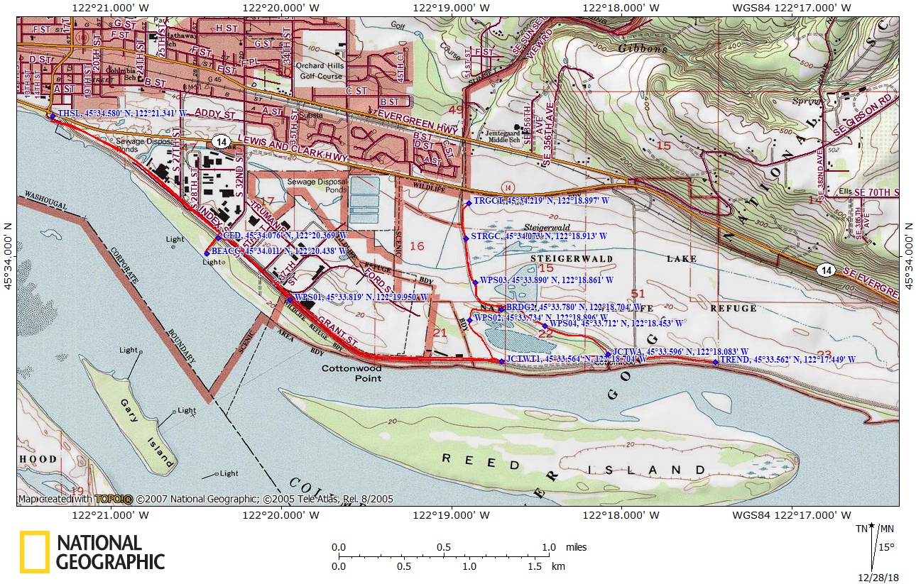
Topo Map, Clark County Map
History:
This area of the Columbia River was a favored place of Native Americans for thousands of years. At the end of March, 1806, Lewis and Clark travelled to a “handsome prairie” two miles upriver from the mouth of Seal River (Washougal River) and directly across from the upper Quicksand River (Sandy River). They planned for just an overnight camp, but the next morning they encountered families of Indians descending the river from the Cascade region. The Native Americans were starving from a lack of food east of the Cascades. The Indians had eaten their dried salmon and the spring salmon run was late so they came to where the Sandy and Washougal rivers meet the Columbia.
The Corps of Discovery decided to camp near Cottonwood beach and “put in a store of meat” to prepare for their trip eastward. They stayed from March 31 to April 6, 1806 to re-provision and explore. The Corps of Discovery camped near Cottonwood Beach in Washougal. William Clark led a group explorers down the Columbia to map the mouth of the Willamette River, which they had missed on both their outward and return voyages.
While Clark was exploring the area, Meriwether Lewis supervised the reprovisioning and the braiding of rope from elk hides that would be used to portage their canoes over Celilo Falls when they reached the Columbia River Gorge. Clark mapped the region during their encampment and historians credit the campsite in Washougal as a key staging point for the Corps of Discovery’s journey back to St. Louis, Missouri.
Excerpt from William Clark’s journal, March 31st, 1806, “we proceeded on about 2 miles above the enterance of this Seacalf river and imedeately opposit the upper mouth of the quick Sand river we formed a Camp in a Small Prarie on the North Side of the Columbia where we intend to delay one or two days to make Some Selestial observations, to examine quick sand river, and kill Some meat to last us through the Western Mountains which Commences a fiew miles above us and runs in a N. N. W. & S. S. E. derection.”
Review: January 19th, 2009. July 11th, 2010.
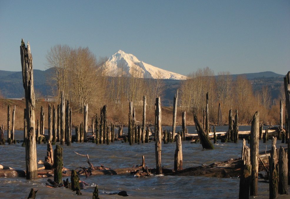
Hike, bike, or run along the north shore of the Columbia River with nice views of Mt. Hood on sunny days. Winds from the Columbia River Gorge can make this a very windy hike. Smells from the waste processing plant which is .4 mile from Steamboat Landing can make the first portion of the trail less than pleasant.
Start from waypoint THSL and head southeast. This trail has hardly any tree cover, which is a consideration on hot summer days. The trail goes along a dike and the openness affords views of Mt. Hood and the surrounding countryside. After about a mile, is waypoint CED at N 45° 34.076, W 122° 20.369. It is an open cedar structure called “Recognition Plaza”. It has signs talking about the Corps of Discovery and their encampment at nearby Cottonwood Beach.
Walk south on a short spur trail to Cottonwood Beach for pleasant views of the Columbia River and canoes made of concrete which look like dugout and native canoes which were described in the journals of Lewis and Clark. There are picnic areas along the beach where you can sit and enjoy the river traffic on plying Columbia River.
Continuing east on the trail for the next .7 mile, there are no views of the river and you pass by an industrial area on the left. The trail also passes more public access points then into the wildlife refuge. The trail passes a barn on the left which is about the last man-made structure to be seen. The nearby ponds and lakes along this part of the trail are part of a national wildlife refuge. The refuge is closed during bird migrations but there are still good views of the migrating birds from the trail.
The gravel trail continues east along a slough of the Columbia River, with Reed Island on the far side of the channel. You pass groves of cottonwood trees near the trail but they are too far away to provide much shade. Pick your spot to turn around and return to the trailhead. On the return to the trailhead, stop at the rest spots and read more about the Corps of Discovery.
This is a popular trail for people with dogs, so expect to see a few dogs off-leash. This trail is totally child friendly, but be cautious of currents, undertows, and dropoffs if you consider swimming. It may sound silly, but you should always wear a life jacket when swimming or wading in the Columbia where there is any current. The Columbia is a powerful river and swimmers drown from undertows nearly every summer.
Enjoy the Photos!
Gallery Pics
Switchback Steve
Recent Comments