

Notice: 5/14/2023 – Hiking between the Yocum Ridge Trail and the Muddy Fork has hundreds of trees down and sections of tread missing because of the September 2020 windstorm. It will probably take another year to repair the damages. Check the USFS for Timberline trail status: USFS. For the latest fire information, please contact the Mt. Hood National Forest Hours: M – F 7:30am – 4:30pm Closed 11:30 – 12:30. Telephone: (503) 668-1700
Directions: From Portland take I-84 East to the Wood Village, exit (16A). Head south and turn left onto NE Burnside Rd. Heading East, Burnside will merge into Highway 26. Follow Hwy 26 to Government Camp. Turn left onto the road to Timberline Lodge.
In winter, it is required to carry chains or have traction devices. The road to Timberline requires chains during much of the winter.
Bathrooms are available at the Wy’East Day Lodge or at Timberline Lodge.
Permits are required to park here seasonally. No parking permit is needed during the summer. A Sno-Park permit is required to park in the winter (Nov. 1st -thru- Apr. 30th).
A wilderness permit is required. The free self-registration for a wilderness permit is along the trail near Mt. Hood Meadows.
Information for the Mt. Hood Timberline Trail with segments showing mileage, profiles, and maps.
Review: 7/30/04 – 8/1/04
This is for backpacking the trail counter clockwise. We arrived at Timberline Lodge about 8:30, which gave us until 9:00 to meet the rest of the group. Tori, Drew, and I walked up to the lodge and admired the displays about Timberline Lodge and its construction. I guess Heidi the St. Bernard is on vacation during the summer.
We met up with Mike and Marleese a little after 9 and we got ready to hit the trail. Drew wanted to hike the trail counter-clockwise, which was fine with all of us. We left about 9:30 after having our pictures taken in front of the Daylodge and then again with Mt. Hood in the background. The weather for the weekend promised to be clear with highs of about 75 degrees.
Drew led the way and the four of us followed. I stopped to take a few picture and dropped to the rear. While composing one of my pictures I stepped on my trekking poles and bent one of them.
You would think I would know better! I got my camera put away, put pack back on, and headed down the trail along a ridge that dropped down to our first stream crossing at White River. We had to scout around for a way across the river. The streambed was a miniature canyon with steep sides and poor approaches. We found a way across, clambered up the sloughing bank, then spent a couple of minutes reacquiring the trail.
The trail follows the river downstream for about 500 feet then switchbacks up a ravine. From there the trail climbs until you come to the chairlifts of Mt. Hood Meadows. We followed the trail under several chairlifts and a couple of nice wildflower meadows with streams flowing through them. The group was hiking pretty fast and I was in the rear most of the morning. After several ups and downs, the trail brought us to Newton Creek, where we stopped for lunch. There was a spring-fed stream just before Newton Creek and I filled up my hydration pack and water bottle from the spring. Everyone else filtered water from the spring. Marleese, Mike, and Drew tended to their hot spots then we had lunch and prepared for the next ascent.
The bridge across Newton Creek is only two skimpy trees. Each of us wondered if we would make it across the muddy creek safely. We all made a dry crossing and started uphill on Gnarl Ridge.
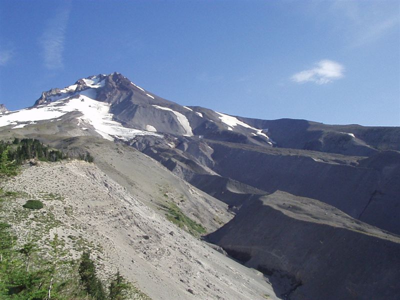
What a slog it turned out to be getting to the top of Lamberson Butte. The trail goes up for miles. At first you’re in the trees but they thin out as you gain elevation. By the time you reach
the high point of the trail at 7300 feet, the trees are dwarf and you’re pretty well spent. Along the way you get great views of Mt. Hood, Mt. Adams, and Mt. Jefferson. We also saw the smoke
from the Log Springs fire on the Warm Springs Indian Reservation. Near the high point in the trail we passed a break in the last big snowfield and Tori found a stream to filter water from. The
stream only appeared for 150 feet. Hikers who walk straight to the cairn instead of following the trail will probably miss this place to filter water from.
We thankfully headed down the trail to the Cooper Spur Shelter. We had our choice of campsites because we were the only campers there Friday night. It is a fantastic campsite. After dinner,
Drew and I walked over to see Elliot Glacier with all its crevasses. Earlier in the day we had talked about hiking up to the 8400-foot level at Tie-in Rock but we agreed we were too tired. We
set up our tents in a light wind and made dinner. The wind blew harder and a big gust pulled out a tent stake from the dusty soil and collapsed my tent. The wind sent the rest of the group
scurrying to find rocks to anchor tents and make windbreaks.
We took refuge inside the stone shelter, talked for a while, then headed to bed. A fine layer of volcanic dust covered all the inside of our tents. You could even crunch it with your teeth
sometimes. Each time a big gust blew my flashlight lit up a little cloud of dust floating into my tent. I put my earplugs in and slept as best I could. I think the wind quieted down around 3
a.m.
We got up around 5:30 a.m. and watched Mt. Adams and Mt. Rainier appear with beautiful sunrise. The sunrise was a beautiful as the sunset the night before. Everyone had interesting experiences
to share. We all had dust. Mike had felt the tent pushing against him with every gust. Drew felt his feet get lifted with every big gust. Tori wondered if her tent stakes would hold down her
tent. I found the stake that holds my tent up had almost pulled out again.
I had breakfast at camp and the rest of the group decided to pack up and make breakfast down at Tilly Jane Campground, near Cloud Cap Inn. It was nice to use the outhouse and talk to some of
the campers. One group had also hiked from Timberline yesterday. They were planning to hike to Paradise Park tonight.
The rest of the group made breakfast and we washed some of the dust off of us. We hit the trail again about 8:30. The next crossing is the Elliot River. (The bridge washed out after this and is now a water crossing.) We continued to have great views of Mt. Hood and the other distant volcanoes.
When we got to Coe Creek, we had a much harder time finding a dry crossing. We had met several people who had waded across. We looked around and were able to find a spot to rock-hop across the
river.
The trail continues near the timberline and great views abounded. Elk Cove had expansive meadows and great views. Cairn Basin, where we had lunch, has a nice wildflower meadow with a view of
Mt. Hood. I don’t understand why Cairn Basin is so popular. Other than the one small meadow, there are many other places on Mt. Hood that seem much more scenic.
We skipped going to McNeil Point but we talked to so many day hikers that we want to go back and see it sometime. From here the trail went along the top of a ridge, which gives outstanding
views of Mt. Hood and McNeil Point.
On the trail towards Bald Mountain, Drew tripped on a root and fell down, banging up his knee and twisting his ankle. We waited for a while then I walked with him slowly. When we got to Bald
Mountain we decided to take the PCT to Ramona Falls because it was shorter and should be a better trail than the Timberline. Most of the trail was switchbacks going down to the Muddy Fork of
the Sandy River. It turns out the PCT has a detour to a new bridge. It is definitely a detour trail and not easy for someone with a tender ankle to negotiate. The new log bridge is sturdy and
should last a long time. The trail hooks into the trail to Ramona Falls shortly after the log crossing. From there it is about 2 miles up to Ramona Falls. We got to the falls and found a group
of students from Springwater High School in Gresham that had hiked over the past week from Timberline Lodge. They were nice enough to show us the group camping area. It is located about 500
feet Southeast of the falls. There was plenty of room at the campsites for all of us and we soon had our tents set up. We rested, filtered water for the next day, then made dinner. I
accidentally left a granola bar out and by the time I found it, only the wrapper remained. I had lain down to eat some trail mix and some nuts spilled out. I looked at the bag and saw chew
marks. The ground squirrel had sampled that too!
After dinner we talked more and then headed off to bed once again. When I got up during the night the full moon made stark shadows through the trees. The night was still pretty warm and the
bugs had gone to bed for the night too. I went back to sleep but was awoken by some animal that sounded like a fire alarm klaxon over and over again. I had to dig out my earplugs again before I
could get back to sleep. The next morning Drew said he thought a bat flying over our camp had made the noise. Tori slept right through the night and hadn’t heard a thing.
Sunday morning dawned clear and about 50 degrees. Mike and Marleese wanted to get an early start and had soon packed up and finished their breakfast. The rest of us had breakfast and broke
camp. From Ramona Falls the trail joins into the PCT and goes from 3400 feet to 5900 feet at Paradise Park. On the way up we had great views of Slide Mountain and some waterfalls. We stopped at
the ruins of the Paradise Park Shelter, which is on the South end of Paradise Park. I took a side trail while Drew rested his ankle and Tori headed down the trail.
Drew and I started down the trail to Zigzag River. After dropping about 1000 feet, we came to an old avalanche that had made a snow bridge across Zigzag River. We crossed, staying away from the
edge and the holes in the snow. We speculated how long it would be before someone fell through because we had heard the snow bridge was only a couple of feet thick in some places. We stood by
the creek and let the cool air wash over us. It was like standing in front of a giant freezer with the door open. You could actually see and feel a cool fog coming out where the stream came out
from underneath the snow. From the river, the trail steeply switchbacks to cross the next ridge at 5700-feet. The terrain becomes drier and sandier as you go more up than down and cross a
couple of small creeks. Pretty soon a communications tower, chairlift, and service road come into view. In less than a ½ mile further, we were back at Timberline Lodge.
We met back up with Tori and congratulated ourselves at the completion of a hike around another volcano. We packed up and headed towards Sandy where we met Mike and Marleese for Pizza.
What great weather we had on this hike. There are certainly some locations we intend to visit again. Including Paola’s Pizza in Sandy.
Enjoy the photos!!
Gallery Pics
Drew’s Gallery Pics
Gallery Pics
Switchback Steve
Recent Comments