

Vicinity Location:
About 12 miles east of Ashford, WA in Mt. Rainier National Park.
Directions:
From Portland, take I-5 North and take exit 68 to Hwy 12. Take Hwy 12 for about 30 miles to Morton. Turn left on Hwy 7 and drive about 17 miles to Hwy 706. Turn right on Hwy 706 and drive to the Nisqually entrance on the west side of Mt. Rainier National Park. Continue several miles past Longmire Inn and park at the Comet Falls parking area or the Christine Falls parking area. The drive takes about three hours.
From Seattle, take I-5 South to Hwy 512 East and go towards Puyallup (Exit 127). Follow Hwy 512 East for about 2 miles. Turn south onto Hwy 7 towards Mt. Rainier. Follow Hwy 7 south to Elbe. At Elbe, turn left onto Hwy 706, travel through Ashford, and then to the Nisqually entrance of Mt. Rainier National Park. Continue several miles past Longmire Inn and park at the Comet Falls parking area or the Christine Falls parking area.
National Park entrance fee must be paid to enter Mt. Rainier National Park. Very popular trail and parking is limited. It is difficult finding parking on sunny weekends.
No outhouse is available at the trailhead.
Length and Elevation:
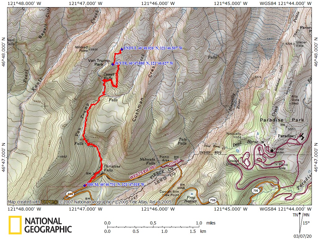
Total length is 5 miles with an out-and-back trail to Van Trump Park. Out and back distance to Comet Falls is 3.8 Miles. Elevation gain to Van Trump Park is 2,900 feet and 50 foot loss. Elevation gain to Comet Falls is 1,700 feet and 330 foot loss. Elevation at the trailhead is 3,670 feet, Comet Falls is 5,090 feet, Van Trump Park is 5,520.
Trail:
Comet Falls Trail with connections to Mildred Point and Rampart Ridge Trails.
Pets, bicycles and saddle/pack animals are not allowed on trails in the National Park.
Trail Maps:
Topo Map, National Park Map, Download Garmin .gpx file
Review: August 22, 2004, Update July 22, 2006, September 20, 2019
Drew, Vernon, and I first stopped at Christine Falls for some photographs. The big floods of last fall have stripped the canyon of vegetation so pictures aren’t as green as in the past. You can see the bridge over Van Trump creek from the Christine Falls viewpoint. We took some pictures, cleaned up some trash, and headed to the trailhead for Comet Falls. The trailhead is about ½ mile West of Christine Falls.
We started this hike on a drizzly Sunday morning. The trailhead is about 3600 feet in elevation. The first part of the trail gains about 150 feet until just after you get across the creek on the footbridge. This bridge is brand-new in 2004. The Park Service had just finished the previous bridge before the big floods in the fall of 2003. The floods scoured out the canyon and washed away the previous bridge, which weighed over 14,000 pounds. The cedar for the new bridge came from other places in the park. The trail crew had to use a chainsaw winch to get the logs from the road, up over Christine Falls, and to the bridge site. In 2004 the bridge was brand new and the scent of cedar was in the air when you crossed the bridge.
After the bridge, climb up the moderately steep trail into the clouds as you quickly gain altitude through several switchbacks. You can tell how popular this trail is because of its width and because the trail is worn down to bedrock in places. There are some viewpoints down into the canyon, short level portions, and then more switchbacks. The first part of the trail is pretty rocky and rooty from all the foot traffic wearing away the soil. The trail is drained pretty well but there are some small muddy places in the trail. Other parts of the trail are quite rocky, so be sure to wear good trail-shoes or boots.
The climb is long along Van Trump Creek through the lush forest of hemlock. As you continue up the steep trail you pass underneath steep basalt cliffs and the trail had to be blasted out of the solid rock. At one point there is a series of about 15 stairs to climb as a reroute because the original trail washed out.
Gaining altitude the forest changes to a mix of Noble Fir, Cedar, and Hemlock. These steep slopes make dangerous avalanche chutes in the winter. After climbing steadily for a couple of miles you come to a viewpoint of Comet Falls. There are some great views even on a cloudy day.
In the fall of 2005 another storm flooded the creek and washed out the bridge over Van Trump Creek, just .2 miles from Comet Falls. No trace of the bridge was to be seen. The bridge has now been replaced and is approximately at N 46 47.603N, W 121 46.758W. When the bridge is washed out, the creek is swift and should only be crossed by experienced hikers and may be uncrossable on hot days. This stream also has a nice little waterfall just upstream that is very picturesque. Climbing up towards Comet Falls there are steep rock stairs and a couple of narrow sections where you need to watch your step.
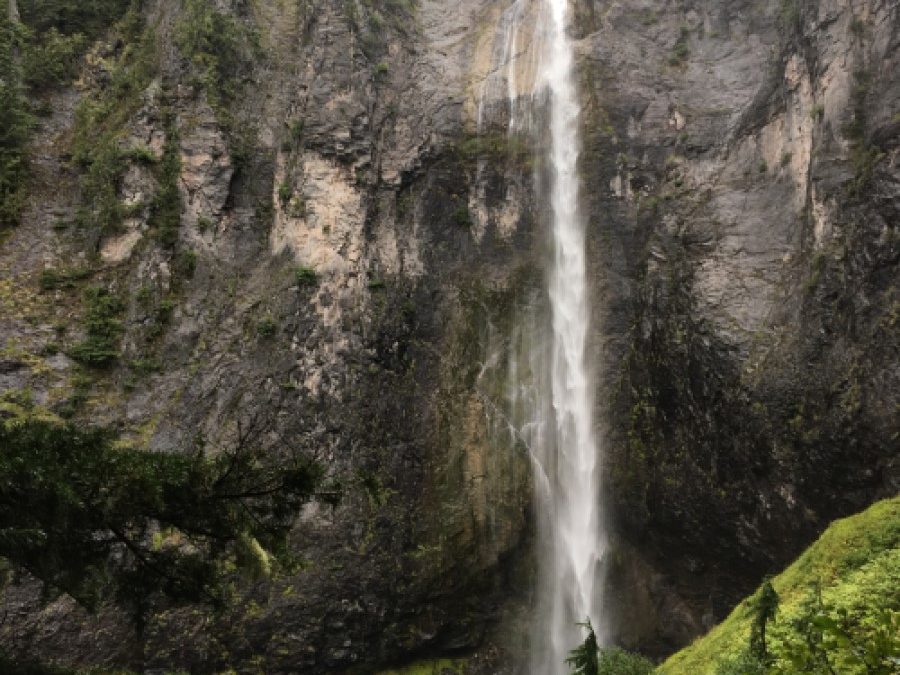
At Comet Falls, we found some logs to sit on and had lunch. Comet Falls is one of the tallest falls in the park and was shrouded in mist. The falls are in two cascades. The main cascade is about 320 feet tall. It got its name because it sort of looks like the tail of a comet. An avalanche or a windstorm has broken off dozens of trees near the waterfall. You get great views from the trail and you can almost walk over to the base of the falls.
The trail becomes much narrower as it switchbacks up the mountain but it does not pass close to the top of Comet Falls. There are a couple small creeks where you could filter water. In about ¾ of a mile is the trail junction that leads to Van Trump Park. The weather kept me from seeing more than ½ mile but I did see Mountain Goats up in the park. I also heard Pikas but didn’t see any of them. The bottom of Van Trump Park is about 5750 feet in elevation. That gives you about 2000 feet of elevation gain in less than three miles.
As you climb away from the junction of the Rampart Ridge Trail and Van Trump Park Trail the trail becomes very poorly maintained. Many of the water bars have washed out and you have to climb up steep sections of the trail. The trees here are Noble Fir and Mountain Hemlock. You can imagine how old some of these trees must be as it looks like they grow only 1 or 2 inches per year.
I hear there are great views from this part of the trail. Checking the map there are other destinations and other viewpoints but they will have to wait for another time and better weather.
Coming back down, I saw plenty of people at Comet Falls. The farther I went back down the trail the more people I saw. When I got back down to the once empty parking lot, it was full. I hear this is one of the most popular trails in the park. Be sure to start this hike early to avoid the crowds and see more wildlife.
There are enough switchbacks and erosion-board steps to satisfy your stair climbing urges. Seeing Comet Falls is a “must”.
Enjoy Some pictures of this hike in the mist!!
Gallery Pics
Switchback Steve

Recent Comments