Eyehike Gallery

Welcome to the Eyehike photo gallery

主頁 / Kings Mtn Photos OR /

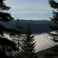
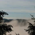
There are elevation signs every 1,000 feet to show how high you have climbed up towards the summit of 3,226 feet on the King's Mountain Trail in the Tillamook State Forest, Oregon.

aae.jpg There are clearings along the trail where there are views to the south and the west of the mountains and valleys of the Coast Range.縮圖Looking west at the first good view of distant mountain ridges from the King's Mountain Trail in the Tillamook State Forest, Oregon.There are clearings along the trail where there are views to the south and the west of the mountains and valleys of the Coast Range.縮圖Looking west at the first good view of distant mountain ridges from the King's Mountain Trail in the Tillamook State Forest, Oregon.There are clearings along the trail where there are views to the south and the west of the mountains and valleys of the Coast Range.縮圖Looking west at the first good view of distant mountain ridges from the King's Mountain Trail in the Tillamook State Forest, Oregon.There are clearings along the trail where there are views to the south and the west of the mountains and valleys of the Coast Range.縮圖Looking west at the first good view of distant mountain ridges from the King's Mountain Trail in the Tillamook State Forest, Oregon.There are clearings along the trail where there are views to the south and the west of the mountains and valleys of the Coast Range.縮圖Looking west at the first good view of distant mountain ridges from the King's Mountain Trail in the Tillamook State Forest, Oregon.There are clearings along the trail where there are views to the south and the west of the mountains and valleys of the Coast Range.縮圖Looking west at the first good view of distant mountain ridges from the King's Mountain Trail in the Tillamook State Forest, Oregon.

aae

作者
Steve Jones
點閱次數
1275
評級分數
沒有評級
評級這張相片

EXIF 資料

Make
Canon
Model
Canon PowerShot S3 IS
DateTimeOriginal
2008:11:30 09:33:47
ApertureFNumber
f/2.7