Eyehike Gallery
Welcome to the Eyehike photo gallery
Menu
Keywords
(0)
Search
About
Notification
OSWORLDMAP
Albums
Mt. Fitz Roy Loop Photos Argentina
23
O-Circuit Patagonia Photos Chile
114
Wyeth-Herman Creek Photos OR
19
Wyeth-Herman Creek Route OR
1
Crosstown Snowshoe Photos OR
18
Crosstown Snowshoe Route OR
1
Sunset Bay Photos OR
10
Sunset Bay Route OR
1
Phlox Point Photos WA
27
Phlox Point Route WA
1
Triangle Pass Photos WA
11
Triangle Pass Route WA
1
Cedar Creek - Alway Trail Photos WA
16
Cedar Creek - Alway Trail Route WA
1
Grand Canyon Photos AZ
77
Grand Canyon Route AZ
1
White River Trail Summer Photos OR
12
White River Trail Summer Route OR
1
Lake Ann Trail Photos WA
32
Lake Ann Trail Route WA
1
Chain of Lakes Trail Photos WA
47
Chain of Lakes Trail Route WA
1
Yellow Aster Butte Photos WA
45
Yellow Aster Butte Route WA
1
Marmot Pass Photos WA
68
Marmot Pass Route WA
1
Seven Lakes Basin Photos OR
36
Seven Lakes Basin Route OR
1
Trout Creek Trail Photos OR
25
Trout Creek Trail Route OR
1
North Head Trail Photos WA
16
North Head Trail Route WA
1
Dune Forest Loop Photos WA
10
Dune Forest Loop Route WA
1
Elkhorn Crest Trail Photos OR
73
Elkhorn Crest Trail Route OR
1
Pacific Crest Trail Section J Photos WA
99
Pacific Crest Trail Section J Route WA
1
Appaloosa Trail Photos WA
17
Appaloosa Trail Route WA
1
Sword Fern Way Photos WA
10
Sword Fern Way Route WA
1
Wizard Way Photos OR
33
Ice Lake - Matterhorn Photos OR
55
Ice Lake - Matterhorn Route OR
1
Lostine - Minam Loop Photos OR
86
Lostine - Minam Loop Route OR
1
Indian Creek Photos OR
18
Indian Creek Route OR
1
Big Tree and Cougar Woods Photos OR
16
Big Tree and Cougar Woods Route OR
1
Cone Peak-Iron Mountain Photos OR
37
Cone Peak-Iron Mountain Route OR
1
Watson Falls Photos OR
12
Watson Falls Route OR
1
White River Falls Photos OR
21
White River Falls Route OR
1
Gumjuwac Trail - Badger Lake Photos OR
22
Gumjuwac Trail - Badger Lake Route OR
1
Deschutes River Canyon Photos OR
34
Deschutes River Canyon Route OR
1
Alpine Lakes Central Loop Photos WA
60
Alpine Lakes Central Loop Route WA
1
Alsea Falls Photos OR
21
Alsea Falls Route OR
1
Ancient Lakes Photos WA
33
Ancient Lakes Route WA
1
Angels Rest Photos OR
43
Angels Rest Route OR
1
Ape Canyon Photos WA
6
Ape Canyon Route WA
1
Ape Cave Photos WA
9
Ape Cave Route WA
1
Augspurger Mtn Photos WA
23
Augspurger Mtn Route WA
1
Bachelor Mountain Photos OR
35
Bachelor Mountain Route OR
1
Bald Mountain Photos OR
45
Bald Mountain Route OR
1
Barlow Butte Photos OR
27
Barlow Butte Route OR
1
Barlow Pass Photos OR
15
Barlow Pass Route OR
1
Barrett Spur Photos OR
30
Barrett Spur Route OR
1
Basin Lakes - Red Mountain Photos WA
43
Basin Lakes - Red Mountain Route WA
1
Battle Ax Mountain Photos OR
25
Battle Ax Mountain Route OR
1
Battle Ground Lake Photos WA
6
Battle Ground Lake Route WA
1
Battleground Lake
8
Beacon Rock Photos WA
15
Beacon Rock Route WA
1
Bells Mtn Photos WA
15
Bells Mtn Route WA
1
Benham Falls Photos OR
8
Benham Falls Route OR
1
Big Creek Falls Photos WA
6
Big Creek Falls Route WA
1
Big Tree Creek Photos WA
15
Big Tree Creek Route WA
1
Bird Creek Photos WA
24
Bird Creek Route WA
1
Blue Lake Loowit Photos WA
57
Blue Lake Loowit Route WA
1
Bluff Mountain Photos WA
16
Bluff Mountain Route WA
1
Bonney Butte Photos OR
37
Bonney Butte Route OR
1
Bridal Veil Photos OR
8
Bridal Veil Route OR
1
Broken Top Loop Photos OR
59
Broken Top Loop Route OR
1
Bunker Hill Photos WA
15
Bunker Hill Route WA
1
Burnt Bridge Creek Photos WA
18
Burnt Bridge Creek Route WA
1
Burroughs Mountain Photos WA
26
Burroughs Mountain Route WA
1
Cape Falcon Photos OR
12
Cape Falcon Route OR
1
Cape Horn Photos WA
44
Cape Horn Route WA
1
Cape Horn WTA Photos WA
40
Cape Lookout Coastal Trail Photos OR
12
Cape Lookout Coastal Trail Route OR
1
Cape Lookout Photos OR
27
Cape Lookout Route OR
1
Cape Perpetua Photos OR
15
Carter Madcap Falls Photos WA
9
Carter Madcap Falls Route WA
1
Cast Creek Photos OR
36
Cast Creek Route OR
1
Catherine Creek Photos WA
12
Catherine Creek Route WA
1
Catherine Creek U Photos WA
6
Catherine Creek U Route WA
1
CatherineCreekPreserve
1
Central Gales Creek Photos OR
12
Central Gales Creek Route OR
1
Cinnamon-Toutle Photos WA
32
Cinnamon-Toutle Route WA
1
Clackamas River Trail Photos OR
32
Clackamas River Trail Route OR
1
Coffin Mountain Photos OR
28
Coffin Mountain Route OR
1
Coldwater Lake Photos WA
56
Coldwater Lake Route WA
1
Comet Falls Photos WA
16
Comet Falls Route WA
1
Cook Hill Photos WA
26
Cook Hill Route WA
1
Cooper Spur Photos OR
28
Cooper Spur Route OR
1
Cottonwood Canyon - Pinnacles Photos OR
48
Cottonwood Canyon - Pinnacles Route OR
1
Cottonwood Canyon Hard Stone Photos OR
12
Cottonwood Canyon Hard Stone Route OR
1
Cowiche Canyon Photos WA
16
Cowiche Canyon Route WA
1
Coyote Wall Photos WA
24
Coyote Wall Route WA
1
Crater Lake Winter 2014 Photos OR
37
Crater Lake Winter 2014 Route OR
1
Cruzatt Rim Photos WA
20
Cruzatt Rim Route WA
1
Dalles Mtn Ranch Photos WA
21
Dalles Mtn Ranch Route WA
1
Dalles Riverfront Trail Photos OR
11
Dalles Riverfront Trail Route OR
1
Deschutes River Photos OR
72
Deschutes River Route OR
5
Devils Backbone Photos OR
21
Devils Backbone Route OR
1
Devils Rest Angels Photos OR
1
Devils Rest Photos OR
15
Devils Rest Route OR
1
Devils Rest Wahkeena Photos OR
16
Devils Rest Wahkeena Route OR
1
Diamond Creek BCRT WA
34
Dillon Falls Photos OR
15
Dillon Falls Route OR
1
Dog Mountain Photos WA
31
Dog Mountain Route WA
1
Dog-Hamilton-Mountains
214
Dog-Mountain-02
49
Drift Creek Falls Photos OR
9
Drift Creek Falls Route OR
1
Dry Creek Falls Photos OR
10
Dry Creek Falls Route OR
1
Duncan Creek Photos WA
11
Duncan Creek Route WA
1
Eagle Benson Photos OR
27
Eagle Benson Route OR
1
Eagle Creek Photos OR
23
Eagle Creek Route OR
1
Eagle Peak Photos WA
12
Eagle Peak Route WA
1
Eagle Wahtum Loop Photos OR
62
Eagle Wahtum Loop Route OR
3
EagleCap 2005 Photos OR
88
EagleCap 2005 Route OR
9
EagleCap 2005 Route OR-aac
1
East Zigzag Mountain Photos OR
18
East Zigzag Mountain Route OR
1
Eastern-Sierras
60
Eds Trail Photos WA
7
Eds Trail Route WA
1
Elk Meadows - Meadows Photos OR
46
Elk Meadows - Meadows Route OR
1
Elk Meadows Photos OR
32
Elk Meadows Route OR
1
Elk Meadows Snowshoe Photos OR
24
Elk Meadows Snowshoe Route OR
1
Elk Mtn Kings Mtn Loop Photos OR
28
Elk Mtn Kings Mtn Loop Route OR
1
Elowah Falls Photos OR
9
Elowah Falls Route OR
1
Emmons Moraine Photos WA
7
Emmons Moraine Photos WA
11
Emmons Moraine Route WA
1
Enchantments Photos WA
201
Enchantments Route WA
3
Equipment Reviews
9
Escure Ranch Photos WA
27
Escure Ranch Route WA
1
Falls Creek Falls Photos WA
18
Falls Creek Falls Route WA
1
Family-trip-2006
324
Fire Lane 12 Photos OR
9
Fire Lane 12 Route OR
1
Fivemile Butte Lookout Snowshoe Photos OR
35
Fivemile Butte Lookout Snowshoe Route OR
1
Florida Dec 09
273
Fort To Sea Photos OR
30
Fort To Sea Route OR
1
Fremont Lookout
18
Frenchman Coulee Photos WA
38
Frenchman Coulee Route WA
1
Fret Creek Photos OR
38
Fret Creek Route OR
1
Frog Lake Buttes Photos OR
34
Frog Lake Buttes Route OR
1
Garfield Peak Photos OR
22
Garfield Peak Route OR
1
Gibbons Creek Photos WA
17
Gibbons Creek Route WA
1
Glacier Basin Photos WA
22
Glacier Basin Route WA
1
Glacier National Park 2017 Photos MT
109
Glacier National Park 2017 Route MT
1
Glacier View Photos WA
29
Glacier View Route WA
1
Goat Rocks - White Pass Photos WA
93
Goat Rocks - White Pass Route WA
1
Goat Rocks Photos WA
111
Goat Rocks Route WA
2
Gobblers Knob Photos WA
27
Gobblers Knob Route WA
1
Grassy Knoll Photos WA
42
Grassy Knoll Route WA
1
Greenleaf Falls Photos WA
18
Greenleaf Falls Route WA
1
Grouse Vista Photos WA
21
Grouse Vista Route WA
1
Grove of the Patriarchs Photos WA
6
Grove of the Patriarchs Route WA
1
Hamilton Mountain Photos WA
39
Hamilton Mountain Route WA
1
Hardy Ridge Photos WA
21
Hardy Ridge Route WA
1
Helens-round-two
35
Herman Creek Photos OR
15
Herman Creek Route OR
1
High Lakes Photos WA
12
High Lakes Route WA
1
High Prairie Photos OR
30
High Prairie Route OR
1
High Rock Overlook Photos WA
21
High Rock Overlook Route WA
1
Historic Columbia River Highway State Trail John Yeon - Cascade Locks Photos OR
35
Historic Columbia River Highway State Trail John Yeon - Cascade Locks Route OR
1
Historic Columbia River Highway State Trail Wyeth - Viento Photos OR
25
Historic Columbia River Highway State Trail Wyeth - Viento Route OR
1
Historic Columbia River Highway State Twin Tunnels Photos OR
22
Historic Columbia River Highway State Twin Tunnels Route OR
1
Horseshoe Ridge Photos WA
7
Horseshoe Ridge Route WA
1
Horsethief Butte Photos WA
20
Horsethief Butte Route WA
1
Huffman Peak Photos WA
24
Huffman Peak Route WA
1
Hummocks - Boundary Trail Photos WA
32
Hummocks - Boundary Trail Route WA
1
Hunchback Mountain Photos OR
22
Hunchback Mountain Route OR
1
Indian Bar Photos WA
34
Indian Bar Route WA
1
Indian Beach Trail Photos OR
22
Indian Beach Trail Route OR
1
Indian Heaven Photos WA
48
Indian Heaven Route WA
1
Indian Henrys Photos WA
30
John Muir Trail Photos CA
465
John Muir Trail Route CA
24
John Muir Trail 2008
408
Jackson Bottom Photos OR
24
Jackson Bottom Route OR
1
Jan-07-snow
10
Jeff Furnia
38
Johnston - Coldwater Peak Photos WA
45
Johnston - Coldwater Peak Route WA
1
June Lake Snowshoe Photos WA
33
June Lake Snowshoe Route WA
1
June Lake Summer Photos WA
9
June Lake Summer Route WA
1
Kamiak Butte Photos WA
15
Kamiak Butte Route WA
1
Kautz Creek Photos WA
15
Kautz Creek Route WA
1
Kings Mtn Photos OR
15
Kings Mtn Route OR
1
Klickitat Trail Photos WA
12
Klickitat Trail Route WA
3
Lacamas Heritage Trail Photos WA
12
Lacamas Heritage Trail Route WA
1
Lacamas Lake Photos WA
24
Lacamas Lake Route WA
1
Lake Eleanor Photos WA
43
Lake Eleanor Route WA
1
Larch Mountain Crater Photos OR
25
Larch Mountain Crater Route OR
1
Larch via Horsetail Falls Photos OR
12
Larch via Horsetail Falls Route OR
1
Larch-Mountain
21
Latourell Falls Photos OR
25
Latourell Falls Route OR
1
Lava Canyon Photos WA
12
Lava Canyon Route WA
1
Leif Erikson Photos OR
12
Leif Erikson Route OR
1
Lewis Clark Discovery Trail Photos WA
9
Lewis Clark Discovery Trail Route WA
1
Lewis River Curly Creek Photos WA
24
Lewis River Curly Creek Route WA
1
Lewis River Quartz Creek Photos WA
21
Lewis River Quartz Creek Route WA
1
Lewisville Park Photos WA
24
Lewisville Park Route WA
1
Little Zigzag Falls Photos OR
10
Little Zigzag Falls Route OR
1
Loowit Trail Photos WA
85
Loowit Trail Route WA
4
Lost Lake Loop Photos OR
17
Lost Lake Loop Route OR
1
Lyle Cherry Orchard Photos WA
21
Lyle Cherry Orchard Route WA
1
Maple Koenig Trail Photos OR
14
Maple Koenig Trail Route OR
1
Marys Peak Photos OR
14
Marys Peak Route OR
1
Maxwell Butte Photos OR
33
Maxwell Butte Route OR
1
Mazama Ridge Photos WA
34
Mazama Trail Photos OR
21
Mazama Trail Route OR
1
McCall Preserve Photos OR
30
McCall Preserve Route OR
1
McKenzie River Photos OR
82
McKenzie River Route OR
4
McNeil Point Photos OR
43
McNeil Point Route OR
1
Memaloose Hills Photos OR
13
Memaloose Hills Route OR
1
Middle Salmon River Photos OR
41
Middle Salmon River Route OR
1
Mirror Lake Photos OR
32
Mirror Lake Route OR
1
Mitchell Point Photos OR
18
Mitchell Point Route OR
1
Morgan Creek Photos WA
11
Morgan Creek Route WA
1
Mosier Plateau Photos OR
17
Mosier Plateau Route OR
1
Moulton Falls Photos WA
20
Moulton Falls Route WA
1
Mountain Flowers
4
Mountaineer Trail Photos OR
18
Mountaineer Trail Route OR
1
Mowich Spray loop
36
Mt Adams Route WA
7
Mt Adams Summit Photos WA
33
Mt Adams Summit Route WA
2
Mt Adams Highline2004
95
Mt Defiance Photos OR
40
Mt Defiance Route OR
1
Mt Fremont Photos WA
18
Mt Fremont Route WA
1
Mt Hood Paradise Photos OR
49
Mt Hood Paradise Route OR
1
Mt Hood Photos OR
12
Mt Hood Route OR
1
Mt Margaret Photos WA
19
Mt Margaret Route WA
1
Mt St Helens Photos WA
19
Mt St Helens Route WA
1
Mt-Defiance
51
Mt-Hood-Snowshoe-Mar-19-2006
11
Mt-Rainier-A-weekend-of-Fun
25
Mt-St-Helens-9-02
49
MtRainier
3
Mult-falls-angels-rest
47
Multnomah Horsetail Photos OR
21
Multnomah Horsetail Route OR
1
Multnomah Wahkeena Photos OR
9
Multnomah Wahkeena Route OR
1
Munson Creek Falls Photos OR
12
Munson Creek Falls Route OR
1
Naches Peak Photos WA
6
Naches Peak Route WA
1
Narada Falls Photos WA
4
Narada Falls Route WA
1
Narada Reflection Lakes Photos WA
9
Narada Reflection Lakes Route WA
1
Neahkahnie Mtn Photos OR
12
Neahkahnie Mtn Route OR
1
Nesmith Point Photos OR
24
Nesmith Point Route OR
1
Newton Creek Photos OR
9
Newton Creek Route OR
1
Northern Loop 2009 Photos WA
131
Northern Loop 2009 Route WA
4
Oak Ridge/Bald Butte Photos OR
27
Oak Ridge/Bald Butte Route OR
1
Oaks To Wetlands Photos WA
15
Oaks To Wetlands Route WA
1
Observation Peak Photos WA
14
Observation Peak Route WA
1
Oneonta Creek Photos OR
15
Oneonta Creek Route OR
1
Oneonta Franklin Ridge Loop Photos OR
27
Oneonta Franklin Ridge Loop Route OR
1
Opal Creek Photos OR
5
Opal Creek Route OR
1
Otter Bench Photos OR
12
Otter Bench Route OR
1
Owl Point Photos OR
11
Owl Point Route OR
1
Owyhigh Lakes Photos WA
24
Owyhigh Lakes Route WA
1
Ozette Triangle Photos WA
72
Ozette Triangle Route WA
1
PCT Little Crater Jefferson Park Photos OR
63
PCT Little Crater Jefferson Park Route OR
10
PNW-03
15
PNWH 17-19 OCT2003
39
PNWH Drew 18-19oct2003
23
PNWH Jan 17-18 2004
15
PNWH Mar 19 21 04
38
PNWH Mar6-7-2004
19
Palisades Lakes Photos WA
27
Palisades Lakes Route WA
1
Palmateer Point Route OR
1
Palmateer Trail Photos OR
12
Palouse Falls Photos WA
18
Palouse Falls Route WA
1
Panorama Point Photos WA
32
Panorama Point Route WA
1
Panther Creek Falls Photos WA
13
Panther Creek Falls Route WA
1
Paradise Narada Photos WA
51
Paradise Narada Route WA
1
Paradise Point State Park Photos OR
14
Paradise Point State Park Route OR
1
Paradise River Snow Photos WA
67
Paradise River Snow Route WA
1
Paradise Valley Road Photos WA
19
Paradise Valley Road Route WA
1
Paulina-Lake
34
Pebble Cr Trail Camp Muir Photos WA
21
Pebble Cr Trail Camp Muir Route WA
1
Phelps Creek Photos WA
38
Phelps Creek Route WA
1
Phelps Creek – Spider Gap – Buck Creek Photos WA
121
Phelps Creek – Spider Gap – Buck Creek Route WA
1
Pinnacle Peak Trail Photos WA
21
Pinnacle Peak Trail Route WA
1
Pioneer Bridle Trail Photos OR
8
Pioneer Bridle Trail Route OR
1
Plaikni Falls Photos OR
9
Plaikni Falls Route OR
1
Pocket Creek Photos OR
32
Pocket Creek Route OR
1
Portland Eastbank Esplanade Route OR
1
Portland Eastbank Esplanade Photos OR
20
Powell Butte Photos OR
18
Powell Butte Route OR
1
Queens River Photos ID
58
Queens River Route ID
5
Rainier Snowshoe Jan 06
24
Rainier black white
16
Ramona Falls Photos OR
11
Ramona Falls Route OR
1
Rampart Ridge Photos WA
11
Rampart Ridge Route WA
1
Rho Ridge Photos OR
23
Rho Ridge Route OR
1
Ridgefield Wildlife Refuge Photos WA
15
Ridgefield Wildlife Refuge Route WA
1
Rogue River Photos OR
80
Rogue River Route OR
7
Ruckel Ridge Photos OR
35
Ruckel Ridge Route OR
1
Saddle Mtn Photos OR
27
Saddle Mtn Route OR
1
Sag Ponds Photos OR
9
Sag Ponds Route OR
1
Sahalie Koosah Falls Photos OR
16
Salmon Butte Photos OR
21
Salmon Butte Route OR
1
Salmon Creek Trail Photos WA
18
Salmon Creek Trail Route WA
1
Sawtooth Mountain Photos WA
13
Sawtooth Mountain Route WA
1
Sedum Ridge Trail Photos WA
12
Sedum Ridge Trail Route WA
1
Serene Lake Photos OR
28
Serene Lake Route OR
1
Shellrock Mtn Photos OR
12
Shellrock Mtn Route OR
1
Silver Falls Photos OR
39
Silver Falls Route OR
1
Silver Shadow Photos WA
17
Silver Shadow Route WA
1
Silver Star
20
Silver Star Indian Pits Photos WA
8
Silver Star Route WA
1
Silver Star South Snowshoe Photos WA
21
Silver Star South Snowshoe Route WA
1
Siouxon Creek Photos WA
15
Siouxon Creek Route WA
1
Siouxon Peak Photos WA
33
Siouxon Peak Route WA
1
Sisters Camp Lake Photos OR
159
Sisters Camp Lake Route OR
5
Sisters Wilderness Photos OR
64
Sisters Wilderness Route OR
13
Skyline Trail Photos WA
35
Skyline Trail Route WA
1
Sleeping Beauty Photos WA
26
Sleeping Beauty Route WA
1
Smith Rock Photos OR
35
Smith Rock Route OR
1
Snow Lake Photos WA
9
Snow Lake Route WA
1
Soda Peaks Lake Photos WA
27
Soda Peaks Lake Route WA
1
South Cinder Cone Photos OR
23
South Cinder Cone Route OR
1
South Sister Photos OR
42
Spray Park Loop Photos WA
43
Spray Park Loop Route WA
1
Starway Photos WA
17
Starway Route WA
1
Steigerwald Lake Photos WA
21
Steigerwald Lake Route WA
1
Step Creek Photos OR
4
Step Creek Route OR
1
Stevens Creek Trail Photos WA
12
Stevens Creek Trail Route WA
1
Stone House Photos OR
19
Stone House Route OR
1
Sun Notch Trail Photos OR
10
Sun Notch Trail Route OR
1
Suttle Lake Photos OR
18
Suttle Lake Route OR
1
Sweet Creek Falls Photos OR
20
Sweet Creek Falls Route OR
1
Table Mtn North Photos WA
28
Table Mtn North Route WA
1
Table Mtn Photos WA
9
Table Mtn Route WA
1
Tamanawas Falls Photos OR
10
Tamanawas Falls Route OR
1
Tarbell - Chinook Photos WA
26
Tarbell - Chinook Route WA
1
Tilikum Crossing Photos OR
9
Tilikum Crossing Route OR
1
Timberline Ramona Falls Photos OR
27
Timberline Ramona Falls Route OR
1
Timberline Trail
132
Timberline Trail 2004
45
Timberline Trail 2004 Photos OR
74
Timberline Trail CW Photos OR
77
Timberline Trail CW Route OR
2
Toketee Falls Photos OR
11
Toketee Falls Route OR
1
Towell Falls Photos WA
21
Towell Falls Route WA
1
Trail of the Shadows Photos WA
12
Trail of the Shadows Route WA
1
Trapper Creek Loop Photos WA
39
Trapper Creek Loop Route WA
1
Trillium Lake Photos OR
13
Trillium Lake Route OR
1
Trillium Yellowjacket Photos OR
19
Trillium Yellowjacket Route OR
1
Triple C Trail Photos OR
5
Triple C Trail Route OR
1
Triple Falls Photos OR
28
Triple Falls Route OR
1
Tryon Creek Photos OR
29
Tryon Creek Route OR
1
Tumalo Falls Photos OR
14
Tumalo Falls Route OR
1
Twin Firs Trail Photos WA
6
Twin Firs Trail Route WA
1
Twin Lakes Photos OR
30
Twin Lakes Route OR
1
Umtanum Creek Photos WA
27
Umtanum Creek Route WA
1
University Falls Photos OR
12
University Falls Route OR
1
Vancouver Lake North Trail Photos WA
10
Vancouver Lake North Trail Route WA
1
Vic Atiyeh River Trail and Ferry Springs Trail Photos OR
24
Vic Atiyeh River Trail and Ferry Springs Trail Route OR
1
Wahclella Falls Photos OR
12
Wahclella Falls Route OR
1
Wahtum Lake Photos OR
27
Wahtum Lake Route OR
1
Wasatch Front Utah
44
Wauna Viewpoint Photos OR
12
Wauna Viewpoint Route OR
1
Weldon Wagon Trail Photos WA
28
Weldon Wagon Trail Route WA
1
Whipple Creek Photos WA
15
Whipple Creek Route WA
1
White River - Boy Scout Ridge Photos OR
18
White River - Boy Scout Ridge Route OR
1
White River Box Canyon
47
White River PCT Photos OR
9
White River PCT Route OR
1
White River Ridge Photos OR
19
White River Ridge Route OR
1
White River Trail Snowshoe Photos OR
22
White River Trail Snowshoe Route OR
1
Whittier Ridge Photos WA
75
Whittier Ridge Route WA
1
Willapa Art - Cutthroat Trail Photos WA
25
Willapa Art - Cutthroat Trail Route WA
1
Wilson River Elk Kings Mtn Photos OR
5
Wilson River Elk Kings Mtn Route OR
1
Wilson River Jones Creek to Footbridge Photos OR
12
Wilson River Jones Creek to Footbridge Route OR
1
Wilson River Keenig Creek - Footbridge Photos OR
16
Wilson River Keenig Creek - Footbridge Route OR
1
Wind Mtn Photos WA
16
Wind Mtn Route WA
1
Wonderland Clockwise Profiles
12
Wonderland Counterclockwise profiles
27
Wonderland-2001
48
Wonderland-2002
139
Wonderland-2003
198
Wonderland-Trail-2004
285
Wonderland-at-Rainier-from-Todd
14
Wyeth Rainy Photos OR
21
Wyeth Rainy Route OR
1
Wygant Peak Photos OR
33
Wygant Peak Route OR
1
Yocum Ridge Photos OR
43
Yocum Ridge Route OR
1
Yosemite Oct 2009
1
alaska2007
128
wta bcrt diamond creek
167
13045 photos
Identification
Login
Quick connect
Username
Password
Auto login
Specials
Most visited
Highest rated
Recent photos
Recent albums
Random photos
Calendar
Home
/
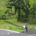
Near the Hantwick Road Trailhead on the Moulton Falls Trail is a sign and trail map.
2861/13045
Thumbnails
Previous
Next
Photo sizes
Photo sizes
✔
XXS - tiny
(240 x 180)
✔
XS - extra small
(432 x 324)
✔
S - small
(576 x 432)
✔
M - medium
(792 x 594)
✔
Original
(800 x 600)
slideshow
Show file metadata
download
aab
Author
Steve Jones
Created on
Sunday 27 June 2010
Posted on
Thursday 2 June 2016
Albums
Moulton Falls Photos WA
Visits
1026
Rating score
no rating
Rate this photo
Powered by
Piwigo
)
)
)
)
)