

Vicinity Location:
About 155 miles northeast of Portland, Oregon and 55 miles east of Seattle in the Okanogan-Wenatchee National Forest.
Directions:
From Portland drive north for about 235 miles to Cle Elum. From Seattle drive east about 80 miles to Cle Elum.
From Cle Elum drive northwest on Hwy 903 about 18 miles, driving through Roslyn. Hwy 903 turns into Salmon La Sac road. Drive 17.5 miles from Cle Elum and turn left on FR 46, crossing over Cle Elum River. Follow FR 46 for 4.7 miles and turn right onto 4616. In about .7 mile, make a slight left onto FR 113 and drive about a mile to the Pete Lake trailhead, passing the horse trailer parking area. Once out of Rosyln, you should be able to follow signs to the northern end of Cooper Lake, which is where the Pete Lake Trailhead is.
A Northwest Forest Pass is required to park here.
A self-issuing Wilderness permit is required.
There is a pit toilet in the parking lot.
Trail: Multiple trails.
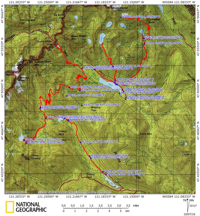
Trail Maps: Topo Map, Download Garmin .gpx file
Length and Elevation:
|
Alpine Lakes – Central Loop |
|||||
|
Itinerary |
Mileage |
Camp elevation |
Ascent |
Descent |
Notes |
|
Day 1 – Cooper Lake – Waptus Lake – |
13.82 |
3,005 feet |
3,600 |
3,400 |
|
|
Day 2 – Waptus Lake – Spade Lake – Waptus Lake – Finished 6:45 pm |
9.9 |
3,115 feet |
3,800 |
3,800 |
|
|
Day 3 – Waptus Lake – Mt. Daniel – Waptus |
22 |
3,120 feet |
7,200 |
7,200 |
11.5 miles to Deep Lake, without Mt. Daniel |
|
Day 4 – Waptus Lake – Lake Ivanhoe – |
9.1 |
3,115 feet |
2,200 |
2,100 |
|
|
Day 5 – Waptus River Camp – Lemai Creek – Finished 4:30 pm |
14.2 |
3,130 feet |
2,830 |
2,870 |
|
|
Day 6 – Spectacle Lake – Cooper Lake – finished 7:15 pm |
16.2 |
2,803 feet |
3,140 |
3,600 |
7.9 without Spectacle Lake |
|
Totals: |
85.22 miles |
68.42 miles for Pamela |
22,770 |
22,970 |
|
Review: 9/12//2016
Day 0 – Travel
Our first day was set aside for final logistics and getting to the trailhead. Pamela had brought the large fuel canister and I convinced her to stop at REI in Olympia to change it out for the middle size that has 8 ounces of fuel. I have found that adequate for an 8 day trip of boiling water for breakfast and dinner. We also picked up another Green Trails map of the area. The next stop was Batteries Plus for a charger and camera battery and we were on our way. Looking back, we should have gotten our NW Forest Pass permit at REI.
A few miles later we stopped at Starbucks for coffee and a snack. We made good time on the freeways except for one slow spot and noticed how congested southbound traffic was. Soon we were away from the urban sprawl and heading east. We got gas and took a bathroom break in Cle Elem, then stopped to take a few pictures in Rosyln. We almost got to camp and realized that we didn’t have a NW Forest Pass so we drove back to Cle Elem and asked around. We found that Stewart Lodge sells them and it looks like there is someone at the front desk until late in the evening.
We got to Salmon La Sac campground after dark and picked a nice single spot with plenty of room for our tents. We saw deer as we entered the campground and 3 more were hanging around our campsite. We set up in the dark, fixed dinner, and soon went to sleep.
Day 1 – Cooper Lake to Waptus Lake
It was a beautiful morning as we made breakfast and went through our gear and decided what to leave behind. On the way out of Salmon La Sac campground I saw a water pump. It had a crank that you turn to pump water and we each took two liters of water. One last time for nice pit toilets, got rid of our trash, and headed to the trailhead,.
We arrived at Pete Lake trailhead and Pamela used the nearby toilet and we started from the well marked trailhead. The trail goes along Cooper River but the river views only last for about a mile. The trail to Pete Lake is a nice gentle walk through a lovely mix of old growth trees and younger trees. There are a few small streams along the way but we pushed on to Pete Lake where we talked to a couple of bow hunters camped on the eastern shore, just past the junction to Waptus Pass. We decided we wanted to take the easier route and not the Tired Creek trail.
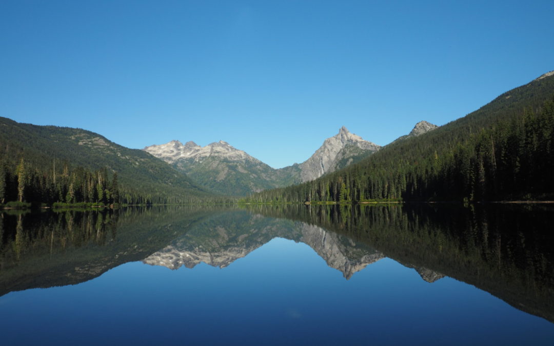
The junction to Waptus Lake is on the right just before you enter a large camping area about 200 feet before the lake. We enjoyed the views at the lake, filtered water, and took the short walk back to the junction. The trail to Waptus Lake soon narrows as it begins a steep climb up the hillside. There are dozens of switchbacks that lead out of the forest, through a sun parched slope, and back into the forest again.
After gaining about 1,300 feet and passing some nice little waterfalls we reached the junction to Escondito Lake, dropped out packs, and walked up to the lake. It was a lot farther than we thought and when we got by the lake there was a hunting camp with two canvas sided cabins with some people lounging around. We said “hi” and walked along a trail to the western shore of the lake for some photos. There were ripe huckleberries and blueberries and their leaves were showing fall colors. On the way back to Waptus Pass we compared this trip to the Enchantments, which has more dramatic scenery than we have seen so far.
Back at the pass we donned out packs and chatted a minute with two campers who were set up by a little stream.
We headed out thinking we were at the top of the pass but we were wrong. There was still quite a bit of gentle climbing and some little descents. We passed the junction for the Waptus Burn Trail which branches off to the right to the PCT and shortly after, the Polallie Ridge Trail. Continue further before finally dropping down a fairly steep trail along Quick Creek. It was some time before we finished switchbacking down to near the lake. There is a washout just where the trail veers right. It took us a minute to puzzle it out but I saw some cut logs upstream. Near the lake was another trail junction that leads a few hundred yards to some nice camps but we wanted to cross the Waptus River that night so we turned right to head southeast and walked and walked. We came to the horse ford and walked on hoping the bridge was in. We saw another signt that said the bridge was out so we went back to the horse ford and waded across the lake outlet which has a gentle flow and is less than knee deep. Pamela saw a small campsite on the left right at the ford so we stayed there because it was getting dark. The map showed some campsites on the south side of the lake but we couldn’t find them.
Day 2 – Spade Lake dayhike -The next morning we broke camp and moved a short distance to one of the nicest spots on the lake. On the way we met Lori who lives in Portland and loves to backpack. We traded contact information and promised to get in touch. The camp has great views up and down the lake and a nice gravel beach. There was even a pit toilet near camp that wasn’t too smelly.
We hung out in camp until about 11 and started up a steep little trail to the Spade Lake Trailhead, off the PCT. The Spade Lake trailhead is just to the right from where the steep little trail meets the PCT. The Spade Lake trail also goes pretty much straight up the mountainside without many switchbacks. In some places the forest is quite open and the sun feels hot as you climb the south facing slopes. It doesn’t look like the deadfalls get cleared out very often because we had to climb over several trunks. We met a woman and her little dog and then an elderly couple who had spent the night at Spade Lake.
After climbing quite a bit, the trail goes up and down a lot and crosses a pretty little waterfall. After quite awhile you get mostly above the trees and we had great views all around. We were able to get Verizon cell phone service in this area. We followed the undulating trail to a beautiful view of Spade Lake ringed by mountain peaks. The trail seemed to stay above the lake where we were. We needed to turn back so we didn’t get a chance to go to Venus Lake. If you want to continue to Venus lake, follow the eastern shore of Spade Lake and scramble up to Venus Lake.
We got back to camp just before dark and remarked how few bugs there were at the lake. Pamela had not hung her food but nothing had bothered it while we were gone. We had dinner and soon dropped off to sleep.
Day 3 – Mt. Daniels and Deep Lake dayhike – I left camp at 6am and when it was just getting light. I climbed up the terrible little trail again up to the PCT and turned right to make my way towards Deep Lake. The trail to Deep Lake is higher than our camp but there are places where the PCT dips down. There are a couple of sets of switchbacks that pass beneath some cliffs and steep hillsides. After the switchbacks there is a junction on the left for Lake Vicente followed by the junction to Deep Lake. The PCT makes a 90 degree right and passes across a nice meadow with Cathedral Rock as a backdrop.
Crossing the meadow brings you to a nice little stream with a couple of campsites nearby. This is the last place to get water until Peggy’s Pond. There are rocks placed to allow you to get across the gently flowing stream and from there into the forest where a long series of switchbacks await.
These switchbacks on the PCT are gentle but take a long time to gain elevation up to the unsigned trail junction to Peggy’s Pond. The trail junction is a trail off to the left at a switchback just before the top of Cathedral Pass. Follow this trail to a tarn just below Peggy’s Pond. It is possible to lose this trail and end up at a scramble. Turn around and look for the trail, it is a reasonably easy trail to Peggy’s Pond.
Once at the tarn, you can follow the user trails up the slopes of Mt. Daniel to the vegetation line. From here, there are a couple of ways up the slopes. Use the map to choose your route. Eventually you will get to a catwalk with great views all around. I stopped at a big rock at the 7,000 foot level, but others continue past and on to the summit. Note that I was able to get Verizon LTE service above Peggy’s Pond.
On the way back down I stopped at Peggy’s Pond and filtered more water and took beautiful photos of Cathedral Rock reflected in Peggy’s Pond. From there it was back down the switchbacks to Deep Lake meeting several PCT through hikers along the way. I like the patterns of all the logs that jam the outlet of Deep Lake.
From there, I moved fairly quickly down the trail and got back to camp at 7:30, just as it was getting dark where Pamela was at camp, having ventured to Deep Lake and spending most of the day there.
The next morning we broke camp after breakfast and moved just a few miles to camp at Waptus River. After setting up camp we started our day ike up to Ivanhoe Lake. Along the way we met a few PCT through hikers that were using the trail to cut off 10 miles. By now many through hikers are in a big hurry to finish. Some had hard dates but others just wanted to be done, with the end of the trail relatively close.
It is a good trail up to Ivanhoe Lake, but like most of the trails we travelled, there are sections full of rocks as the horses have worn away all the dirt and turned the trail into a rut. Ivanhoe Lake is beautiful and we decided to hike around the lake on a rustic trail that rises and falls as it circumnavigates the lake. We found a nice spot for lunch on the west side of the lake and admired the mountain peaks that ring the lake. The weather was turning cloudy but we only felt a few passing raindrops during the day. We had heard the forecast was for rain the next day. I had Pamela leave her pack cover because I didn’t think it was going to rain, so I improvised a pack cover from a garbage bag, cording, and duct tape.
We made our first campfire and I put my pot over the fire to cook dinner. After dinner I went down to the river and brought back water to put out the fire at the end of the evening. As we went to bed we wondered how much rain we were in for.
Day 4 – About 3:50am we heard the first wisps of rain. The intermittent sprinkles gradually turned into a light rain by breakfast but we stayed dry under the trees. We headed up to climb two passes. The trail climbed steadily up switchbacks and the rain got steadily harder. After a few hours we were getting totally soaked. I stopped to put on my fleece and Pamela added donned her hat and gloves. She had brought some hot hands but for some reason we tried 6 and none got warm. We met a few backpackers heading north as we climbed through the fog and rain.
Eventually we got to the first pass and by then I had forgotten there was a second pass. I was looking forward to dropping down into the trees and getting warmer but the trail keeps meandering and overall gently climbing. We stopped again and Pamela had to take her raincoat off and put on another layer. We were just about shivering by the time we were done. We had a little snack and persevered into the chilly rain. Finally we started dropping down but there had been a forest fire and only charred trunks remained and the wind was blowing harder on this side of the pass.
Pamela was moving at a trot and I kept pace, hoping she didn’t have to stop for a pee along the unsheltered trail. The trail switchbacks down a very steep slope and slipping off the trail would be very painful.
Finally we passed through groves of trees which offered some protection from the wind. Here we found a few through hikers camped out at the switchbacks with no water around. We continued down and the trail became very brushy but by then we were totally wet so it didn’t matter. We finally made it to Lemah Creek and found another through hiker hunkered down for the day. I helped Pamela pitch her tent and that finally warmed me up a bit. I got my tent set up and mopped out the water with my wet socks. I always bring a Nalgene bottle and I made a hot water bottle, got into my sleeping bag, and put the Nalgene at my feet to warm me up and dry them out.
I camped in the open so I could listen for breaks in the rain to make a dash for water. On my first dash out of the tent I took the nearest water and it was rather brown. As I made my meal I thought about the horse smell in the area, all the rain, and the thought of that creek draining a horse meadow used for 100 years turned me off to eating that meal. I waited for a break in the rain to dash out again.
While getting dressed to go get better water I tipped over my pot and spilled some of my dinner in the tent. Out came the wet socks to mop up the floor again, just when it was beginning to dry out. I soon found a path to the much larger and cleaner looking Lemah Creek and ventured out on some logs to get water. I didn’t mind boiling the water as I didn’t want to stand around filtering water getting colder by the minute. Back into the tent and I boiled the water. Some went into my Nalgene and the rest was for dinner. Finally I was warm and comfortable, listening to the rain. We had talked to some people who told us the bridge was out and a big log was across the trail. We talked it over and thought that since we were leaving the PCT, we might not encounter those.
Day 5 – The next morning the rain had stopped but nothing was dry. Pamela decided to hike out and dry things out so she could go on another backpacking trip. I decided to dayhike to Spectacle Lake, backpack to Cooper Lake and spend the night so we could get an early start back to town.
We set off along a mostly level trail for about a mile where we found the trail junction to Spectacle Lake flooded and no bridge for the Spectacle Lake Trail. We filtered water here then parted ways for the day. I stashed my pack and waded across Lemah Creek. Thinking back on it, I should have used my camp shoes then stashed them in the bushes for the return trip.
I moved up the gently rising trail enjoying the sunshine as I slowly dried out. Pretty soon the climb starts in earnest and the trail goes through an old forest fire with blackened trunks all around. There are some little streams to step over then after negotiating a bunch of switchbacks you come to a spectacular waterfall on the stream that drains Spectacle Lake, Delate Creek. From here it is a bunch more switchbacks to the junction that leaves the PCT and goes a short distance to a fantastic overlook of Spectacle Lake.
Drop down to the lake by following the most obvious trail which joins a small network of trails near the lake. Taking paths that lead left provide nice views and a few campsites. Return back along the same path, winding back down the switchbacks to the junction with the PCT. Continue back through the forest and wade the creek. The creek is about 50 feet wide, normally about knee deep, and flows fast even in summer. The creek rises with rains and during spring runoff so there are times when the it is too dangerous to cross the creek.
From the junction of Pete Lake Trail and the Lemah Meadow Trail, continue on a gently rolling trail along Lemah Creek to the shores of Pete Lake. There are several nice places along the lake to camp. You can camp here or if you want to get an early start, you can finish the trip back to Cooper Lake.
From Pete Lake to Cooper Lake the trail seemed very different than on the way in. The recent day of rain made the trail seem completely different. Multiple puddles and little mudholes had to be negotiated. The climbs and drops seemed taller than on the way in. I made it back to the trailhead just before dark and walked down the Cooper River trail marking potential campsites with a stick in the trail so I could find it in the dark. I finally found a wonderful spot near the lakeshore.
For camping at Cooper Lake, follow the Cooper River trail down from the parking lot. There are a few primitive sites under the trees and then some campsites along the lake.
Day 6 – Break camp and drive home.
Enjoy the photos!!
Gallery Pics
Switchback Steve
Recent Comments