

Vicinity Location:
About 20 miles northeast of Vancouver, WA in the Yacolt Burn State Forest and Gifford Pinchot National Forest.
Directions:
From Portland drive North on I-5 from Vancouver and take exit 11 then turn right and take highway 502 5.8 miles to Battle Ground. You can also take I-205 to exit 30B and then highway 503 from north to Battle Ground.
From the main intersection at Battle Ground (Highway 502 and 503 near the Fred Meyer store)
Drive North on highway 503 for 5.6 miles and turn right onto Rock Creek Road. There should be a sign saying “Lucia Falls, Moulton Falls”.
Drive east for 8.6 miles as Rock Creek Road becomes Lucia Falls Road.
Turn right on Sunset Falls Road. There’s a sign saying “Sunset C. G.” and drive for 2 miles.
Turn right on Dole Valley Rd, cross over the East Fork Lewis River on a narrow bridge, and follow the paved road generally uphill 2.4 miles.
At 18.6 miles from Battle Ground, turn left onto gravel road L1100 and drive 2.2 miles on a gravel road to a wide intersection. Turn right and proceed about 300 feet to the Tarbell trailhead. There is parking for about a dozen cars but this trail is not heavily used.
A Discovery Pass permit is required to park here.
There is a pit toilet at the parking area.
Trail:
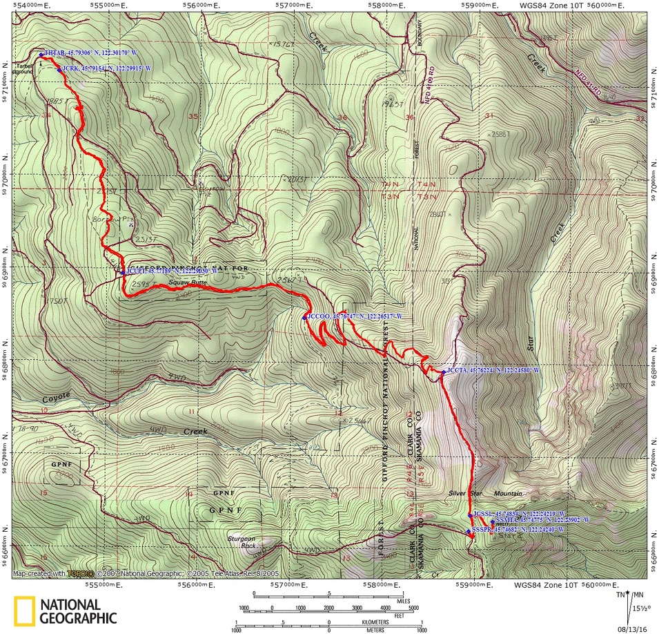
Tarbell Trail, Chinook Trai #180B, Silver Star Trail #180, Silver Star Mountain Trail #180D with connections to Ed’s Trail #180A, Bluff Mountain Trail #172, Indian Pits Trail #180E.
Trail Maps:
Topo Map, National Forest Service Map, Download Garmin .gpx file
Length and Elevation:
Total distance is 15.5 miles. Trailhead elevation is 1873 feet. Highest point is 4,390 feet.
Total elevation change is 3,100 up and 3,100 down.
To the top of Silver Star Peak the elevation change is 2,590 feet up and 487 feet down. The distance is 8 Miles, including the stop at the spring.
Review: 7/24/2016
The trail starts out going through an old clear cut with second growth trees quickly taking over. This is a fairly level trail at first, gently rising as it proceeds through clear-cuts and islands of older trees.
Far in the distance you can see the summit of Silver Star Mountain. After walking only a bit you come to a trail Junction that leads to Hidden Falls, Rock Creek, and Grouse Vista. Turn left at this Junction for Silver Star Mountain.
Cross to logging roads within the first two miles but the trail is directly across the road so there is no problem finding your way. This section is an actively logged area so what is forest one year may become clear cut the next. This diversity allows hundreds of different kinds of plants in the forest and meadows. For example, I saw white and red Baneberry along the trail.
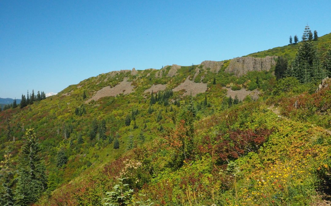
Climb almost a continuously for about the first two and a half miles then drop down for about ¾ mile to pass across a saddle and start climbing again up to the junction of the Chinook Trail #180B. The junction is at 3.75 miles, about half way up to the summit of Silver Star. Turn left at the junction and head uphill, leaving the Tarbell trail behind and begin crossing hillsides that open up to views around the area. This is part of the old Yacolt burn and the trees still have not totally reclaimed the hillsides.
About 5 miles into the trip, you come to a large x Junction with the trail on the left going to steeply up the hill. Take the narrower trail which is the Chinook Trail and climbs a gentler grade. Don’t forget this Junction on your way back so that you can stay on the the trail. Climbing along through the meadows there’s dozens, maybe hundreds of butterflies in the summertime.
At about mile 4.5 walk by a nice patch of Thimbleberries which ripen in July. You’ll also see a couple bushes of red huckleberries along the trail that ripen in August.
Ascend through small patches of forest and mountain meadows full of wildflowers in mid-July. Soon you can see Mount Rainier, Mount Adams, along with Mount St. Helens. The path steepens as it uses an old Jeep road for a bit and at 6.1 miles is the junction of the Chinook Trail and Silver Star Trail where you turn right and continue uphill. After 7.25 miles you get to a three-way junction at the top of a little rise in the trees. The left trail goes up to Silver Star, but if you want water, continue over and downhill a bit and turn right at the next junction and after walking less than a quarter of a mile from the 3-way junction you will see a small little path on the right that leaves the old Jeep Road. This small, fairly level path leads to the spring and some wonderful water flowing out of a rusty pipe. This spring normally flows all year but in a severe drought can dry up.
After replenishing your water supply, head back to the 3-way junction and turn right, passing by a campsite, then turning left at the false summit and following the trail to the old fire lookout and the summit of Silver Star at 4,390 feet. On a clear day you can see all the main volcanic peaks in the area and the columnar basalt of nearby Sturgeon Rock is always an eye-catching sight.
On the way back down be sure to turn left where the Chinook Trail 180B branches off the Silver Star Trail. Enjoy the easy walk down through the open Meadows and patches of forest back to the trailhead.
Switchback Steve
Recent Comments