
Notice: 6/1/2023 – This trail open. SR504 – Spirit Lake Memorial Highway remains closed to all travelers at milepost 43 near the Science and Learning Center.
Vicinity Location:
The trailhead is about 42 miles north of Portland, Oregon in the Mt. St. Helens National Monument.
Directions:
From Portland take I-5 North to exit 49 for Castle Rock. Turn right towards Mt. St. Helens and drive about 46 miles on Highway 504. This will take you past the Lakes Trailhead for Coldwater Lake to South Coldwater Trailhead. Turn left into the parking area.
A shuttle hike is possible by parking at both Lakes Trailhead and South Coldwater Trailhead. An alternative is to park at Lakes Trailhead and walk the road at the beginning of the hike instead of the end of the hike, but a parking permit is required for this option.
No bathrooms are available. Bathrooms are available at the nearby Lakes Trailhead.
No permits are required at this trailhead. A Mt. St. Helens National Volcanic Monument Visitors pass is required to park here.
The access to this trailhead can be closed during the winter.
Length and Elevation:
12 miles roundtrip, elevation gain 1,700 feet and loss 1,400 feet to Lakes Trail. Total gain and loss is 3,600 feet. Trailhead elevation is 2,520 feet.
Trail:
South Coldwater Trail #230A, Lakes Trail #211 with access to Coldwater Trail #230.
There are no geocaches on this trail.
Trail Maps:
Topo Map, Download Garmin .gpx file
Trail Races:
Early September – Backcountry Rise 50K – Daybreak Racing
History:
This trail is entirely in the blast area from May 1980. Any green trees have grown since then. Coldwater Lake was created when the debris flow from the 1980 eruption of Mt. St. Helens flowed down the North Fork of the Toutle River and raised the level of the valley so much that Coldwater Creek was dammed by more than a 200 foot thick lahar flow. Coldwater Lake is about 3.5 miles long and up to 200 feet deep.
Review: July 15, 2012
This hike is entirely in the blast zone and Mt. Margaret backcountry. That means that most off-trail wandering is not allowed. There are two access points to the lake on the Lakes Trail and on the right side of the Coldwater Trail. All other areas are restricted to entry.
The trail enters the woods and begins gently climbing uphill through a young forest of mostly alder trees. After several switchbacks the trail comes out of the forest and continues to climb the ridge. Soon the remains of a logging spar pole come into view next to the trail and after climbing a bit more, a big rusted hunk of equipment, a yarder, comes into view along the spine of the ridge. The hot blast debris scoured all the paint off the equipment leaving a rusting hulk on the hillside. Look for wild strawberries growing low to the ground. Maybe you’ll find a couple of berries to eat. On the ridge there is also a destroyed and partly buried Caterpillar tractor.
The trail is well marked with round posts to help find your way when snow covers the trail early and late in the season. Just a couple hundred feet after passing the bulldozer, look down towards the lake and on a bench near the lake is an old fire truck that was destroyed by the blast.
Continuing along the ridge you can see areas that has been logged before the 1980 blast and areas where the unlogged trees were laid down by the blast. Whole hillsides have silver-grey tree trunks all pointing away from the Mt. St. Helens crater.
For the next mile the trail traverses the left side of the ridgeline using an old logging road for the about the next mile. Looking northwest to Coldwater Ridge, you can still see thousands of tree trunks covering the ridge like quills of a porcupine, all of them snapped off in an instant from the 1980 blast.
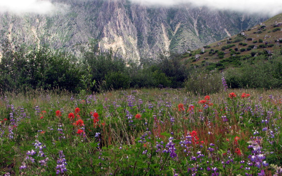
The trail generally descends, passing through fields of wildflowers and at 3.4 miles from the trailhead you reach the junction of the Coldwater Trail #230. Near here is another piece of logging equipment destroyed in the blast, the rusted, giant metal drive-tracks jutting into the sky like some sort of modern industrial sculpture.
Take the left junction and continue generally northeast through an ever increasingly brushy trail. About .2 mile after the junction the trail drops down, crosses a small stream, and continues downhill. This section of trail is not often maintained so you may encounter tall brush and small trees fallen across the trail. The brush also invites many early summer bugs so you’ll want to pass through this nearly 2 mile section without stopping for long.
The trail switchbacks down fairly steeply and comes to a nice bridge crossing about 30 feet above Coldwater Creek. The sturdy bridge provides nice views into the creek below and to Coldwater Lake to the southwest. Having travelled about 5.3 miles, the bridge is a convenient place to take a break and enjoy the sights and sounds at the bridge.
After crossing the bridge over Coldwater Creek the trail is pretty well brushed out. Climb up a couple of switchbacks and pass views of the lake and creek to the junction with Lakes Trail #211. Turn left here (all turns at trail junctions have been to the left), and head generally downhill towards Coldwater Lake and the trailhead, 4.5 miles away.
The trail crosses a couple of small streams, goes up, goes down, goes underneath a couple of big old logs, and wildflower meadows make a reappearance. Near the head of the lake is a huge beaver lodge on a tranquil pond. At about .6 mile from the junction are signs for lake access. Just at the second access sign there is a brushy trail to the lake but no beach. Just a couple hundred feet farther along the trail is a sandy path leading to a nice beach with plenty of logs for backrests or benches. A small stream empties into the lake at the southern end of the beach. This is a great place to take a break and watch the birds flying about and listen to the waves lapping on the beach.
About 7 miles from the start of the hike, the trail crosses a large alluvial fan which developed from the mountainside which slid and washed down into the lake. Each winter brings rocks down to cover portions of the trail and you’ll need to look for flagging and rock cairns to pick up the trail on the far side of this rocky area.
The trail follows the shoreline of Coldwater Lake pretty closely the rest of the way back to the Lakes Trail trailhead and the wildflowers become abundant. There is a bit of a cliff down to the lake along most of this section and the trail varies from about 10 feet to 40 feet above the lake.
Towards the south end of the lake, Mt. St. Helens comes into to view if the weather permits and at about 1 mile from the trailhead there is an area where boats dock on the left and there is a solar powered composting toilet in a building on the right.
There are a lot of wildflowers along this section of trail in the spring and early summer. Foxglove, Paintbrush, Lupines, and various yellow and white flowers make a picturesque scene. The trail crosses numerous small streams coursing down the steep hillside. It is nice to hear the sounds of the waves lapping at the shore as you walk along.
The last mile is an easy walk and there are even benches to sit and enjoy the view. Soon the scenic trail reaches the parking lot for Lakes Trailhead and Birth of a Lake loop trail. This point is less than 7.5 miles from Mt. St. Helens crater and everything is this area was stripped of everything green.
By now you’re probably tiring and there is still the walk along the road back to your car. Make your way out to the road and turn left. You will want to cross to the other side of the road before reaching the bridge because there is a pedestrian walkway on the southern side of the bridge. From the bridge you can look downstream and see Coldwater Creek disappear over the top of a waterfall.
Cross back over the road after the bridge and walk back to the car, passing a branch of Coldwater Creek and some small ponds.
This is a good hike for cloudy days because of the limited shade on the trail and Mt. St. Helens is not the main focus of this trail.
Enjoy the photos!!
Gallery Pics
Switchback Steve
Recent Comments