

Vicinity Location: The trailhead is about 87 miles southeast of Portland, Oregon in the Lower Deschutes BLM lands.
Directions:
From Portland to Macks Canyon take I-84 East to the Wood Village, exit (16A). Head south and turn left onto NE Burnside Rd. Heading East, Burnside will merge into Highway 26. Follow Hwy 26 past Government Camp continue on Hwy 26 for about 16 miles and turn left onto OR-216 E.
Drive 25.8 miles on OR-216 E and turn left onto US-197 N/OR-216 E and drive 7 miles.
Turn right to continue on OR-216 E and drive 8.4 miles.
Turn left onto BLM Access Rd for Macks Canyon Campground and drive 17.4 miles to the end of the road.
There are restrooms at both ends of the trail and a few along the route.
Length and Elevation:
Distance is 38.6 miles one way. Trailhead elevation is 600 ft. Highest point is 650 feet in elevation. Lowest point is 200 feet in elevation. Elevation gain is 1,000 feet and elevation loss is 1,450 feet.
There are no geocaches along this trail.
Trail:
Deschutes River Trail.
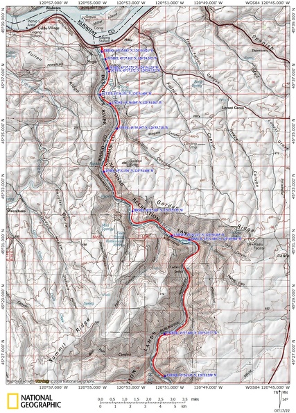
Trail Maps:
Topo Map, Download Garmin .gpx file, Open Garmin .gpx file
Review: March 12, 2022
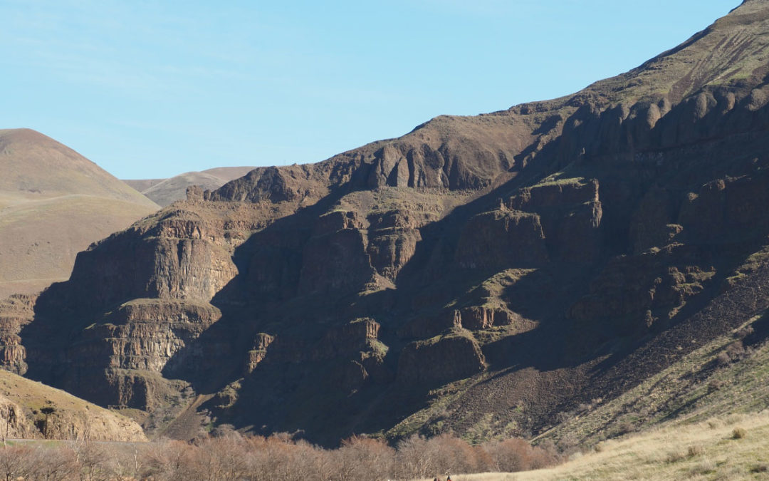
Following the railroad grade you soon pass underneath tall cliffs which have shed numerous rocks and boulders down onto the old railroad grade making footing a little treacherous. Having poles is really nice through this section. This lasts on and off for about the first mile and then you pass out from beneath the cliffs and there are just occasional rocks to contend with..
The views along here are so pleasant with the river rushing by. I love its soft sounds as the water flows through the deep canyon. The only other sounds you hear are the few trains each day that go along the tracks on the other side of the river. An occasional powerboat or rafter may go by. I imagine there are a lot more rafters when the weather is hot.
At about mile 3 1/2 you have a choice; you can go above and get a nice view of the river or continue through the railroad cut as it goes around the bend in the river. The views from the top are nice and you can see a long way down the river. You’re still fairly high above the river but this bend is the first spot where there is an easy trail down to the water if you need to refill.
After about 5.6 miles the trail makes a large bend to the right. Leave the trail and head down the hill. You’ve come to an old Jeep track that you can follow for a bit then walk downhill to a flat spot along the river. There are plenty of small tent sites mingled among the rocks.
This first day was pretty easy. We got in to camp about 2:30 in the afternoon. It wasn’t very hard to set up camp and we were lucky in that the wind was just a gentle breeze kissing our cheeks. I enjoyed smelling the sagebrush and the Yarrow along the trail and a few wildflowers were in bloom such as a small pink flower and some yellow fritillaria. We didn’t see anyone else on the trail. During the evening we talked about food and someone mentioned a book they liked: Memorable Backcountry Meals: 44 Recipes Worth Making by Lisa Holmes.
Day two is a straight road walk. The railroad trail is level and wide with just one stream crossing with rocks in the mud to help you across. Again, it is really nice to have trekking poles to keep your balance walking over the little rocks sticking out of the mud. Just before the Stream Crossing is a little side trail that climbs up to some cliffs. Just as you go around the corner and once you get to be underneath the cliffs there should be some petroglyphs that you can see just above your head. If you go further down the trail it seems to branch with one leg going steeply uphill and the other leg following along the cliffs. There is nothing more to see if you follow along underneath the cliffs. There is a small cave at the top of the little gully that the trail branches off but you should consider carefully whether you should take this as it can be wet and slick and it is steep.
Just after that creek you will pass where Harris Ranch used to be. It burned up in a fire in about 2017. Also back by the petroglyph trail there was an old water tower which also burned up in the fire. About the only thing left to see is of the water tower is the rock pedestal where the plaque talking about the restoration of the water tower used to be.
We made camp at a site with a pit toilet by the river. From camp you can take a user trail which starts across the railroad bed from camp. I went up the edge of a ravine and crossed over to the old jeep trail which you can see on the side of the canyon in the distance. Follow the jeep trail up switchbacks all the way to the top of the canyon.
When you get near the top you’ll pass through a couple of different kinds of gates and continue up to where this climbing road, Rattlesnake Grade, intersects the powerline road. Turn left here and walk about a half mile to a set of power poles on a bit of a promontory. From here there are some rocks at the edge of the canyon that you can stand on and you get a spectacular view down to where you started along the river. On a sunny day you can see Mount Hood and Mount Adams. Once you’ve enjoyed the view, turn around and return the way you climbed up.
Descend the switchbacks and on the last big switchback that seems to jut out into the canyon, leave the road and follow the ridgeline down and to the right. You will drop down and look to cross where two gullies join together. Look for a little side-hill trail that leads back up to Rattlesnake Grade. Once you’re there make your way down Rattlesnake Grade until you can see the roof of the vault toilet. From there continue down the trail a little bit and then look at the gulley on your left and cut off the old jeep trail to follow the little user path along the top of the gulley back to camp.
Day three begins with an easy walk along the old railroad grade. You’ll pass another bathroom and then at about 4 1/4 miles you start passing some very interesting columnar basalt. The basalt is sideways instead of vertical and in Curvi patterns. Show me the parents in the form and I after that Trail dropped down across the stream and there is another bathroom.
In about 4 1/2 miles you’ll cross a small stream which has stepping stones on one side. This is a great place to get water if you need some. After the stream start climbing back up to the old railroad grade. If you follow the grade above this road you’ll be able to see where this detour is because there was once a high Trestle over the stream.
Follow the railroad grade passing several sets of rapids as the trail winds through the canyon. Continue on the old railroad grade all the way back until you can see the parking lot then take the little trail that leads down to the parking lot. If you miss this trail you have a couple more trails that go to the parking lot.
Enjoy the photos!!
Gallery Pics
Switchback Steve
Recent Comments