

Vicinity Location:
About 85 miles northwest of Portland, OR in Leadbetter Point State Park Park.
Directions:
From Portland: drive I-5 north for about 43 miles and take exit 36 toward WA-432 W.
Drive 4 miles and turn left onto Oregon Way/Hwy 433 and head towards Oregon Hwy 30.
Drive 1.4 miles across the Longview bridge and turn right to merge onto US-30 W toward Clatskanie/Astoria.
Take Hwy 30 for 47.7 miles and turn north onto Hwy 101 N then drive for 13.2 miles, crossing the Astoria Megler Bridge and through the community of Chinook, WA and Ilwaco, WA.
Turn right onto US-101 ALT and drive 0.6 miles to where the road “T”s and turn left onto US-101 S and drive 1.9 miles.
Turn right onto Sandridge Rd/WA-103 N and drive for about 20 miles to the trailhead.
A Discover pass is required to park here.
There are bathrooms at the trailhead and the northern parking lot.
Length and Elevation:
5.1 miles roundtrip. Elevation at the trailhead is 15 feet. Total gain is 50 feet and loss is 50 feet. Highest elevation is 43 feet and the lowest elevation is sea level.
Trails:
Dune Forest Loop Trail, Weather Beach Trail with connections to Bay Loop Trail.
There is a geocache along the trail at: N 46° 35.898 W 124° 02.320 Info at Geocaching.com
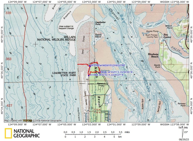
Trail Maps:
Topo Map, Download Garmin .gpx file, Open Garmin .gpx file
Review:August 24, 2023
Start by the restroom and head towards the ocean. The first part of this trail might be very brushy but after about a quarter of a mile you go underneath a forest canopy and the trail opens up a little bit. There are lots of bracken, fern, salal, and other kinds of brush along the trail. The trees here are mainly Sitka spruce and you’ll see some of their little cones on the ground.
In about 0.8 miles the trail makes a large, looping, horseshoe switchback, and gently climbs a sand dune into a more open forest. There are pine trees, Salal and other bushes.
At about 0.9 of a mile you come to a trail Junction where you can either go straight ahead or sharply to the right. The Dune Forest Loop Trail leads sharply to the right and gently downhill.
Once again, the trail passes through a seemingly impenetrable walls of brush, and frequently the canopy closes in above you so that you are walking underneath an arch of brush.
After about 1.25 miles you’ll pass through some more open areas with very spiky bushes growing into the trail. If this is not pruned back soon, you will not want to wear shorts on this hike.
After about 1.5 miles the trail comes back out into sandy soil that does not support dense undergrowth.
At about 1.6 miles my map shows a Junction with the Weather Beach trail but that trail is actually a bit further.
The trail climbs up a sand dune and comes to a junction for the Weather in Beach Trail on the left. To the right is the continuation of the Dune Forest Loop Trail.
In a short distance, you reach the junction for the Weather Beach Trail. Take this trail to reach a long beach on the Pacific Ocean. Head back into the brush and in the winter and spring there are a couple of mud holes in the first 500 feet of the trail. If you take this trail in the winter you will need some kind of a way to wade through the 6 inch deep puddles.
In a little over 2 miles come out of the trees into the beginnings of low dunes leading to a sandy beach. You’ll enter a wildlife refuge where no dogs are allowed. There are a couple of signs so either turn around if you have a dog or leave your dog at home.
Where the trail leads to the ocean both sides along the trail are closed to public entry for snowy plover nesting. Please stay on the trail and don’t wander into the nesting area. The beach itself is open to the public, but the dunes are closed.
After reaching the ocean, you can walk up and down the deserted beach and then return back to the junction with the Dune Forest Loop Trail. Make a left at the junction and climb up a low sand dune towards the northernmost parking lot.
At about 4 miles you reach the junction for the Bay Loop Trail. You can take that and once again go out to the ocean or go to the bay. For this hike continue about 100 feet along the trail until you reach the next trail junction, which is also for the Bay Loop Trail, and the Dune Forest Loop Trail. Turn left here and walk down to the bay.
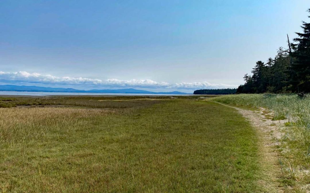
Head towards the bay and you will come to a wildlife viewing platform. Continue towards the bay and find a well trodden trail just before the mud flats begin. Turn right here, and head south back to the trailhead along the Willapa bay. There are nice views along the bay and the trees that have fallen onto the mudflats provide extra interest and a bit of a challenge to climb over.
High tides mostly cover this trail along the bay. Be sure to know the timetables. Link to tidetable
Enjoy the photos!!
Gallery Pics
Switchback Steve
Recent Comments