

Vicinity Location:
About 100 miles northwest of Portland, OR in Cape Disappointment State Park.
Directions:
From Portland: drive I-5 north for about 43 miles and take exit 36 toward WA-432 W.
Drive 4 miles and turn left onto Oregon Way/Hwy 433 and head towards Oregon Hwy 30.
Drive 1.4 miles across the Longview bridge and turn right to merge onto US-30 W toward Clatskanie/Astoria.
Take Hwy 30 for 47.7 miles and turn north onto Hwy 101 N then drive for 15.3 miles, crossing the Astoria Megler Bridge and through the community of Chinook, WA and Ilwaco, WA.
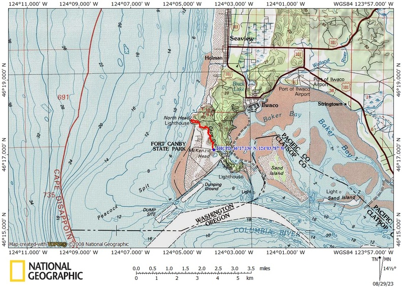
In Ilwaco turn left on 2nd Ave SW and follow W-100 S for 3.6 miles as the road changes to Ft. Canby Road and use the parking lot for the Lewis and Clark Monument/Battery 247 Trail.
You can use Google Maps and route to: Lewis and Clark Monument, McKenzie Head Trail, Ilwaco, WA
A Discover pass is required to park here.
There are no bathrooms at the trailhead. There are bathrooms at the North Head Lighthouse parking lot.
Length and Elevation:
3.8 miles roundtrip. Elevation at the trailhead is 10 feet. Total gain is 411 feet and loss is 411 feet. Highest elevation is 144 feet and the lowest elevation 10 feet.
Trails:
North Head Trail, Weather Beach Lighthouse Keepers Loop Trail, with connections Battery 247 trail.
There are no geocaches on this trail.
Trail Maps:
Topo Map, Download Garmin .gpx file, Open Garmin .gpx file
Review: August 24, 2023
The Trail starts near McKenzie head where members of the Lewis and Clark expedition made their first campsite on the Pacific Ocean. It is a short hike up the connecting Battery 247 in Trail to the top of McKenzie head for ocean views and to see the old gun emplacements.
From the parking area go across the road, turn left, and walk about 150 feet to the start of the trail.
The trail starts out going across what was once the ocean but it has filled in over time and now provides for a flat trail for the first 1/3 of a mile. After that the trail starts climbing fairly steeply and becomes very rough and Rooty.
Several kinds of ferns along with Salmonberry, la, evergreen huckleberry, thimbleberries, and many other plants line the trail. You pass beneath trees and bushes of salal, Salmonberry, and elderberry. As you wind your way through the forest there are some boardwalks and boards in the trail to help you through the spots that are muddy even in the summertime.
This next mile of the trail is fairly challenging with short but steep ups and downs and a lot of roots to negotiate. In the winter you can expect this trail to be very muddy and not recommended for hiking.
There are plenty of old-growth trees that are fairly large mixed in with younger Sitka spruce and hemlock trees. Some of the Sitka spruce have interesting shapes after being battered by dozens of years of winter storms.
As you get near the lighthouse, the trail improves and you get some views of the ocean through the trees.
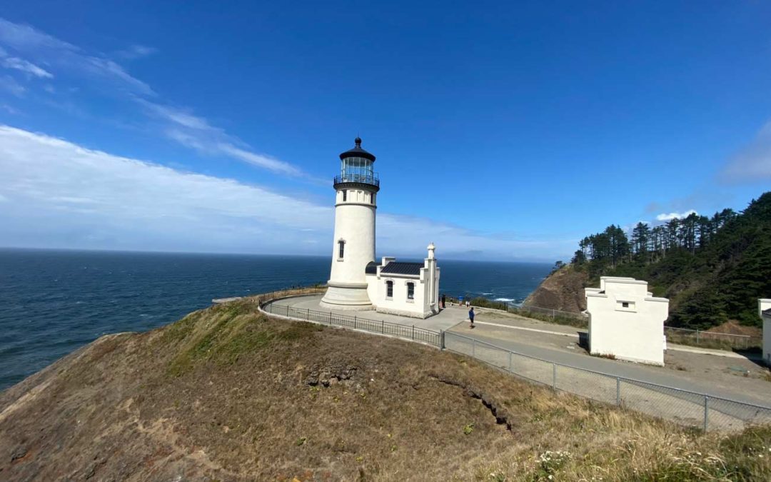
Once you get to the parking lot, turn left and follow the wide paved pathway around the lighthouse keepers house to the lighthouse. This is the Lighthouse Keepers Loop Trail and goes to the North Head Lighthouse then leads to a concrete sidewalk up to the lighthouse keepers house and a gift shop.
Once back to the parking lot, retrace your way back along the North Head Trail to where you parked.
This is a pleasant, though somewhat challenging walk to the north head lighthouse. It is not suitable for bikes because of all the routes and very short, but steep accents along the trail. This is a good trail for tracking polls. Children may enjoy seeing the different sites along the trail, but they may not enjoy all the routes.
Enjoy the photos!!
Gallery Pics
Switchback Steve
Recent Comments