

Vicinity Location: The trailhead is about 207 miles northeast of Portland, Oregon in the Alpine Lakes Wilderness and the Mt. Baker-Snoqualmie National Forest.
Directions:
Set up a car shuttle between the Stevens Pass and Snoqualmie Pass trailheads. Parking at the Snoqualmie Pass trailhead is very crowded on weekends.
There are pit toilet bathrooms at each trailhead.
Length and Elevation:
Elevation at the Stevens Pass trailhead is 4,100 feet. Elevation at the Snoqualmie Pass Trailhead is 3,012 feet. Total distance is 76.8 miles. Highest point is 5,990 feet, lowest point is 3,012 feet. Total ascent is 22,367 feet and total descent is 23,832 feet.
| Itinerary | Mileage | Camp Elevation | Ascent | Descent | Notes |
| Day 1–Stevens Pass-Josephine Lake-Started 2:25 pm – Finished at 6:00 pm | 5.8 | 4698 | 1832 | 1286 | Snoqualmie Pass trailhead parking was overflowing. Waited about 15 minutes for a spot |
| Day 2–Josephine Lake-Surprise Lake-Started 7:35 am – Finished at 2:50 pm | 10.7 | 4498 | 3104 | 3301 | Dished tent site flooded in rain |
| Day 3–Surprise Lake-Deception Pass-Started 7:50 am – Finished at 2:00 pm | 9.8 | 4229 | 2473 | 2736 | Found a small camping spot next to the trail |
| Day 4-Deception Pass-Waptus Lake-Started 8:05 am – Finished at 5:13 pm | 10.1 | 2982 | 2826 | 4083 | Large camp at lake. Great swimming at this large lake |
| Day 5–Waptus Lake-Escondido Ridge-Started 7:55 am – Finished at 3:30 pm | 10.1 | 5490 | 3918 | 1576 | Didn’t see lake from trail. Missed it first time |
| Day 6–Escondido Ridge-Spectacle Lake-Started 7:55 am-Finished at 2:20 pm | 10.8 | 4252 | 3115 | 4384 | Few camps on east side of lake |
| Day 7–Spectacle Lake-Ridge Lake -Started 8:10 am – Finished at 6:25 pm | 11.7 | 5262 | 4129 | 3222 | East end of Anthony Lake is shallow and has muddy bottom |
| Day 8–Ridge Lake-Snoqualmie Pass-Started 8:25 am – Finished at 12:45 pm | 7.8 | 3012 | 970 | 3244 | Lots of day hikers |
| Totals: | 76.8 | 22367 | 23832 |
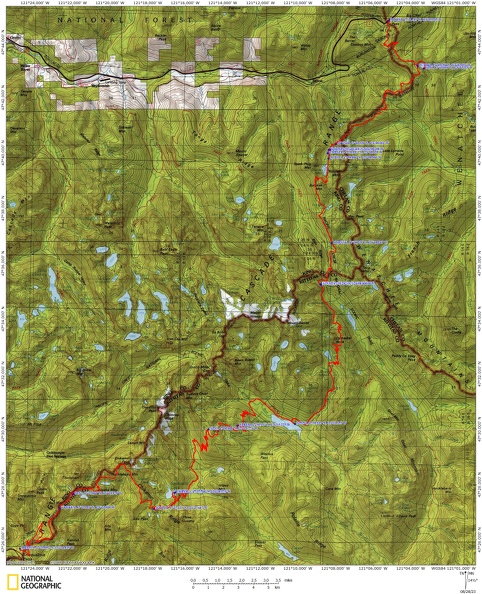
Trails: Pacific Crest Trail #2000, Section J
Trail Maps:
Topo Map, Download Garmin .gpx file, Open Garmin .gpx file
Review: July 23, 2023
Day 1 – July 23 – Stevens Pass to Josephine Lake
Climb up from Stevens Pass mostly in the trees. Switchbacks lead to the top of a chairlift where the are great views. Cross over the ridge and switchback down the other side and cross a small creek.
Start a gentle climb for a mile or so then climb more steeply up to a campsite near a small lake. Switchback up to another lake then continue on the PCT to the junction for Icicle Creek Trail. Turn left and meander up and down for a while before descending fairly steeply down to several nine campsites. I think the farther sites are better and there is one more past the little boulder field.
Day 2 – July 24 – Josephine Lake -Surprise Lake
We started about 8 am and stopped by the pit toilet heading out of camp. There is a sign right on the trail so you can’t miss it. We climbed back up to the PCT and continued climbing up to Hope Lake. The lake appears to be shallow with water grasses around most of the shore. There is a very large flat campsite on the shore and a smaller campsite past the lake a bit.
Climb a lot up to the junction down to Trap Lake. Climbing above Trap Lake brings you out of the trees onto a steep, rocky mountain slope. The trail is level for a bit but then climbs steeply up switchbacks to Trap Pass. The trail immediately switchbacks down towards Surprise Lake.
About halfway down the switchbacks we took Trail 1060A which continues to switchback all the way to the lake. We turned left and found a couple of campsites.
Surprise Lake is a really pretty Lake and we would have swam in it if it wasn’t so windy and cloudy when we arrived. We found a site near the junction Trail 1060 and I had Sean take the flatter site. We went down the trail along the lake looking for more campsites but didn’t see much. There must be at least one site hidden above the lake because we saw two other campers when we first got to the lake. We got all set up and a light mist started coming down. We got into our tents and took a nap. The mist let up so I explored the outlet of the lake and that end of the lake. I only found one tiny site. When I got back we fixed dinner and sat under some trees to avoid the rain. We went to bed early and the rain poured several times during the night. Some water splashed into my tent but everything was mostly dry the next day. When I took down my tent I could see where water had puddled under my tent. Sean’s tent site was in a bit of a bowl and he had a big puddle. Anything sitting in his vestibule got wet and some water came through the floor of his tent.
Day 3 – July 25 – Surprise Lake – 1 Mile past Deception Pass
We had breakfast and packed up our wet tents. It is a steep climb from the lake back up to the PCT. Once back to the PCT we climbed up to Glacier Lake. Another big climb up to Pieper Pass then down to Deception Lakes. There are some nice campsites on Deception Lakes.
From there a relatively easy climb to Deception Pass then down to where we camped. We. Camped in the forest at Mile 2443.0 at an elevation of 4,207 feet. There is room for two tents and maybe two more on a slope. You can hear a mountain stream and water is about 509 feet back up the trail. Also back up the trail another 500 feet is a large stream with a waterfall upstream a bit.
Day 4 – July 26 – Deception Pass Area to Waptus Lake
Sean and I had oatmeal for breakfast with instant coffee. I went back to the waterfall for some early morning pictures with the sun on the falls. I took some nice wildflower pictures near the falls too. We traveled about .75 miles to the ford. Early in the morning it was no issue at all. There are a few choices, some upstream, some downstream. We chose upstream and found a place not too swift and a nice pool to wade through. The water was thigh deep for me and Sean found a part a little shallower. While we were putting on our socks and shoes a woman arrived and crossed on the rocks and sticks but got her foot wet.
We got on what we thought was the trail and headed downhill. It leads to a nasty scramble that is not the trail. Just after crossing the creek you need to look for the trail going uphill. It may be partially obscured by rockfall.
From here it is a mostly steady climb up to Cathedral Pass. There are nice views of the valleys and near the top there are awesome views of Cathedral Peak.
We took lunch in a wide, shaded spot before the pass. Dropping down we took off our packs and headed for Peggy’s Pond. We reached a spot in the trail where you have to scramble about 15 feet down a rock face and we turned around since we had a long ways to go.
We descended many switchbacks with some nice views of Deep Lake. The trail mostly descends but there are plenty of places where it climbs a bit too. There are a couple big sets of switchbacks and brushy meadows of shoulder high thimbleberry obscuring the trail.
Continuing down you enter forests with less undergrowth and a mix of dirt and rocky sections of trail.
Eventually you reach a junction for Spade Lake and just after that is the junction dropping down to a trail near the lake. This is a steep, crummy trail but is only about 0.2 mile long.
We turned left at the trail junction and found a really nice campsite. There are not as many campsites to the right but there are some nice campsites.
I went for my first swim of the trip in the lake and it felt great.
Day 5 – July 27 – Waptus Lake to Escondido Ridge
We had breakfast of Cream of Wheat with cinnamon and brown sugar and Sean had blueberry oatmeal and we both had coffee. We used the pit toilet and started at 8am, our earliest start. We took the trail along the lake but you don’t actually see much of the lake. We saw a few more campsites along the lake than a nice one at Waptus River. There is a big wood bridge over Waptus River. From there the trail climbs gently at first then steeply up many switchbacks through the forest and brush. The forest thins as you climb and you get many great mountain views as you climb. Waptus Lake comes into view many times. The climbing continues up Escondido Ridge and there is no available water.
Eventually you pass a stream that could have a trickle of water in it and then in about a mile you come to Escondido Tarns.
We continued to seesaw up and down until we got to a small lake where we camped for the night. Another Great Lake for swimming and just a few mosquitoes. We got the best campsite at the lake overlooking the lake and mountains behind it. Across the valley to the south is a rugged mountain range with sheer cliffs of thousands of feet. Today was by far the most scenic day of the trip.
We had dinner, shared some whiskey, and went to bed.
Day 6 – July 28 – Escondido Tarn to Spectacle Lake
Pikas woke us to a beautiful morning for backpacking. We both had a lot of condensation in our tents, so much that it dripped off the inside or our rainflys when we shook them. We had breakfast,packed up our wet tents, and headed down the trail. The morning was a long descent to Lemah Meadow. I’m the morning most of this is in the shade.
The bridge is out at the river in the valley but there is a long log over the river a bit downstream that we used.
From there we started climbing through the forest. There are some level sections of trail within the first couple of miles but after that it is a steep climb for the most part.
There is a series of switchbacks climbing through an old burn and it is in the full sun. We were thankful for a breeze for this section.
The rough trail enters back into the forest and a lot of the trail is a deep gully with rocks switchbacking up and up.
Eventually we came to the signed junction for Spectacle Lake. We heard the old trail is mostly impassable so be sure to use the trail at the signed junction.
We were able to trace out the main trail to the peninsula and found a good campsite with a view of the lake. There are some little ponds nearby which serve as a breeding ground for mosquitoes but the wind did a great job of keeping them away.
I explored the other shore for campsites but saw very few. I found a place sheltered from the wind and took a swim in the lake. I also looked for the toilet and found the location indicated on my map and it looked like there was a spot where a toilet once was but it is gone.
Our friends Pamela and Sylvia backpacked in from Cooper Lake and joined us for the rest of the trip.
Day 7 – July 29 – Spectacle Lake to Ridge Lake
The chipmunks didn’t bother our food because it was stored in a bear can and Ursacks. Our packs are feeling lighter now that we’ve eaten most of our food.
There was a lot of condensation inside our tents and we packed them up fairly wet. I left my tent out as long as possible and it dried out some.
We headed up from Spectacle Lake and continued climbing up Chikamin Ridge. The rapid ascent provides some nice views of Spectacle Lake.
The trail leveled out a bit near Park Lakes where we took a break and I went for a swim. We thought since the day was just over 10 miles and this was day 7, we would knock out this segment.
We continued up Chikamin Ridge on a rocky trail then went through a saddle and discovered a 3 mile traverse along the ridge where the trail was loose rocks of various ankle-twisting sizes. We made less than 1 MPH over this section and it was tiring because you had to concentrate on most every step.
Finally we started passing high above mountain lakes. First was Joe Lake and Edds Lake. By then we were hoping Edds Lake was our lake for the night but then we had to climb up the slopes of Alaska Mountain and pass high above Alaska Lake.
Finally we got to Ridge Lake after 5 pm. We were lucky to find a place to camp on the east side of the lake. The wind was steadily blowing making it too cold to swim but keeping most of the mosquitoes away but some lanced through my socks while I was cooking.
I was thankful the lake was pretty close to our camp because the wind felt pretty cold and for the trail being about 10.5 miles long it kicked my ass.
Day 8 – July 30 – Ridge Lake to Snoqualmie Pass
Hard to believe the last day had arrived but my food told the story. Just enough to get through lunch with a snack in reserve and I had a second cup of instant coffee.
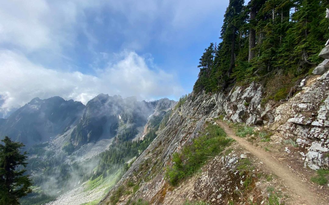
We had a short climb back up to the trail then an ascent of about 150 feet to the Kendall Catwalk. I have been on narrow parts of the PCT so I didn’t know what to expect. The catwalk is a fairly wide trail blasted out of the rock slope of the mountain. There are pieces of rebar where there used to be rocks that served as a guardrail. The catwalk has great views since it goes through a narrow saddle on the ridge. You can see down to Snoqualmie Pass and hear freeway noise but soon the mountains block the noise until you get close to the trailhead.
After that the trail enters the forest and starts dropping towards the parking lot.
This is a very popular day hike and we had to step off for dozens of people as we got closer to the end.
The last mile or so of the trail had been brushed and the tread cleaned up. Other than all the crosscut saw work to clear the deadfalls across the trail, this was the most trail maintenance I had seen over the 75 miles of trail we backpacked.
I highly recommend this trip itinerary. We had great campsites and fantastic scenery. There are some really jagged peaks and mountain crags thousands of feet high.
Enjoy the photos!!
Gallery Pics
Switchback Steve
Recent Comments