

Vicinity Location:
About 32 miles northwest of Portland, OR in Beacon Rock State Park.
Directions:
From Portland take I-205 North; drive past the Portland Airport Exit and cross the Columbia River. Move over to the right lane as you cross the bridge. Take exit 27 for Vancouver/Camas and move into the left lane on the off ramp heading towards Camas. Follow SR-14 to Beacon Rock State Park which is just before Milepost 35.
Kueffler Road comes up just before the Park Headquarters of Beacon Rock State Park. This is a Y-Intersection and if you miss Kueffler Road, you can turn left about 50 feet after the Kueffler Road street sign.
Follow the winding paved road uphill for just over 3 miles. Along the way it turns into a gravel road. About 1.6 miles from Highway 14 is a sign that says “Private Road” that has been put up by local residents. This is not a private road. Continue up the gravel road and it turns into a dirt road.
Turn right at a grassy area that fits about four cars next to the road.
There is no bathroom at the trailhead. The closest public restroom is at Beacon Rock State Park equestrian trailhead.
No permits are needed to park at the trailhead.
Length and Elevation:
13.3 miles roundtrip. Elevation at the trailhead is 1,600 feet. Total gain is 3,500 feet and loss is 3,500 feet. Highest elevation is 2,923 feet and the lowest elevation 1,600 feet.
Trails:
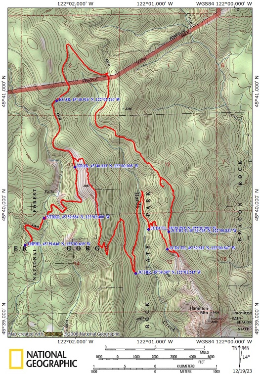
East Hardy Ridge Trail, Bridge Trail, Upper Hardy Creek Trail, Don’s Cutoff Trail, with connections Hamilton Mountain Trail and Hardy Creek Trail.
There is a geocache along the trail at: N 45° 40.195 W 122° 01.83 Info at Geocaching.com
Trail Maps:
Topo Map, Download Garmin .gpx file, Open Garmin .gpx file
Review: December 16, 2023
From the parking area heading in just a few hundred feet turn left just after the fire ring, looking for indistinct trail that goes up the hillside and joins an old forest Road. Follow this forest Road up about three-quarter of a mile to stream crossing.
You should be able to find a spot to hop across using rocks in the stream and then continue on up turning left to follow the stream valley for about 1000 feet where once again you turn right and leave the stream.
The trees are mostly hemlock, and the lower section is very brushy with vine maple and salmon berries. As you get higher, the salmon berries thin out, and then the under story is mainly Swordferns.
Continue climbing through the forest using several switchbacks and after about 1.6 miles you reach the first level spot in the trail. Here the trail climbs through a second growth forest which is turning into hemlocks and Noble fir trees. Grand fir trees, and Douglas fir trees. The understory is changing to Oregon grape, and some huckleberries.
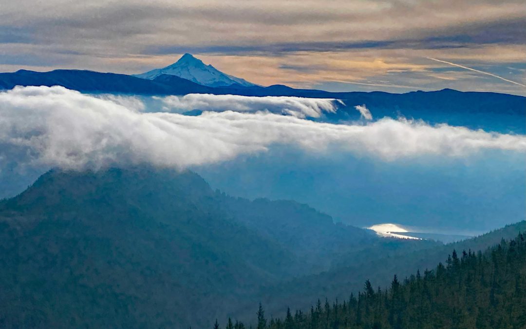
Below Phlox Point the old road levels out and starts dropping in elevation. Choose a good spot to leave the road and Bushwhack up to the ridgeline. Follow the ridgeline south through trees and brush to Phlox Point. From Phlox Point heading south the trail is in very good shape and easy to follow. Soon you start dropping down towards a four-way junction. Along the way there are nice open ridge views of Mount Hood and Mount Adams.
At the four-way junction make a dog leg left and continue on the very nice trail through the forest second growth forest.
Turn left onto the Bridge Trail and cross the big bridge and then go up and then take Don‘s cut off trail. Where Don’s Cutoff Trail rejoins the service road, continue uphill, and walk out to the saddle for nice views of the Gorge. From there take the upper Hardy Creek Trail.
Leaving the saddle, a there is a short steep climb up the trail, which is an old road, for about 1000 feet. After that, there’s a long level section that goes along a Ridgeline. At the first junction we continue to the right to stay on the upper Hardy Creek Trail. it is also a second growth forest of Douglas fur and hemlock trees. At first, the trees are the second growth, but as you get back .4 mile, you encounter much larger trees that are 2 to 3 feet across. They are hemlock trees. This section the trail is very easy walking because it’s an old forest Road.
Leaving the state park the trail rapidly deteriorates to be a brushy track that goes on for a mile or so. After another mile or so, you gently climb up out of the forest to a large set of powerlines. Once you make your way to the powerlines, go on a very nice gravel road to a five way junction and turn left.
Follow the gravel road as it curves around to where you can look back towards the spot where started on the gravel road. At the junction where one road goes uphill and the other stays on fairly level ground, go to the left and stay on the fairly level track and negotiate through a ditch across the old road.
The track enters the forest and in about a quarter mile is an old abandoned car. Maybe a Ford Fairlane. A few hundred feet past the old car is a trail going off to the left. Take this instead of continuing steeply uphill.
This old road leads back to where you climbed up to Phlox Point. From here follow the old road across the creek and turn left at the user trail that leads back to where you parked.
This is a lovely second growth forest with a fairly heavy tree canopy and very little undergrowth along the old forest road.
Enjoy the photos!!
Gallery Pics
Switchback Steve
Recent Comments