

Note: The roads leading to Triangle Pass are typically gated and closed between December 1st and the end of May.
Vicinity Location:
The trailhead is about 75 miles northeast of Portland, Oregon in the Gifford Pinchot National Forest.
Directions:
To the Triangle Pass Trailhead: From Carson, Washington take Wind River Highway to Bear Creek Road and turn right. Continue on Bear Creek to the Forest boundary where it becomes Forest Road 6808.
Stay on Forest Road 6808 for about 7 miles to the junction with Forest Road 68 at Triangle Pass.
No permit is needed to park at the Triangle Pass Trailhead. Northwest Forest Pass is required to park at the Dog Mountain Trailhead and a special parking permit is needed at the Dog Mountain Trailhead during the wildflower season on weekends.
No bathrooms at the Triangle Pass trailhead. Pit toilet at the Dog Mountain Trailhead.
Length and Elevation:
12.9 miles one-way. Elevation at the trailhead is 2,405 feet. Total gain is 3,192 feet and loss is 5,492 feet. Highest elevation is 3,668 feet and the lowest elevation 100 feet.
Trails:
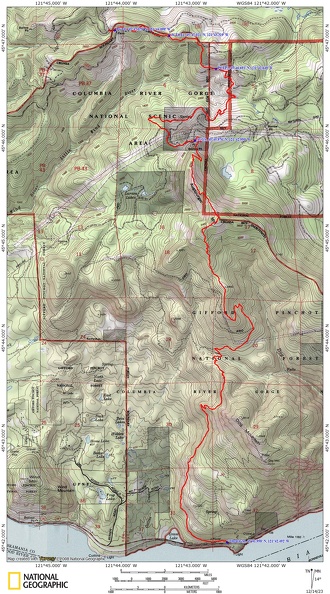
Cascade Crest Trail, Augsperger Trail with connections to Dog Mountain Trail.
Trail Maps:
Topo Map, Download Garmin .gpx file, Open Garmin .gpx file
Review: November 26, 2023
After dropping off a car at the Dog Mountain Trailhead, drive east to the Cook-Underwood road, through Willard and to Triangle Pass.
From the 3-way road junction at Triangle Pass walk southwest down FR 68 for about 150 feet and look for a faint trail on the left that goes uphill into the forest. This is the old Pacific Crest Trail and Cascade Crest Trail that once went from Dog Mountain Trailhead and passed by Big Huckleberry Mountain.
The trail has a gentle grade as it traverses a small ridge heading east. In about 0.25 mile is a curious hole in the ground next to the trail that seems to have warm air coming out of it. At 0.75 mile is a saddle where you can easily drop down to FR580 and step over numerous small deadfalls for about 2.25 miles back to FR68.
The trail continues east for about a mile from the trailhead. There are some large old-growth trees along the trail and the forest is a mix of older second-growth hemlock and maple trees with an undergrowth of Oregon Grape, salal, and vine maple.
As the trail turns south it starts descending about 400 feet in the next 0.4 mile. There are a few views of the Little Wind River Valley along the way.
At 1.5 miles you reach an abandoned forest road which you walk on for a couple hundred feet then head off the right shoulder of the road after the small scree field. Continue through the old second-growth forest for about 0.6 miles to a small creek which is the Little Wind River.
Continuing down the Cascade Crest Trail the condition of the trail deteriorates with more brush and deadfalls in the trail. There are a few bits of flagging but mostly GPS and route finding skills are needed to follow the trail. There is one big jack-straw pile that has to be navigated around but mostly the deadfalls are single or double trees across the old trail.
About 0.4 mile from the Little Wind River there are some maps that show a trail climbing up to the Larson Lakes forest road but for this route, continue along the track for the Cascade Crest Trail.
We were able to generally follow the route for 0.85 mile but then gave up due to running out of time. We hiked up a mostly underbrush-free slope for .2 mile up to Larson Lakes Road and turned left, heading east. In 0.6 mile we came out of the trees underneath power towers and made our way to the Augsperger Trail.
The trail goes into the woods and starts climbing gently but quickly steepens and starts climbing the ridge. There are some large trees sheltering the trail but the ridgeline becomes more exposed as you climb higher.
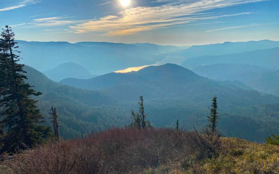
There is a rocky scree field to cross and climbs to provide views of Mt. Adams, Mt. Rainier, and Mt. Adams.
Hike across mountain meadows which face west mostly below the ridgeline. This is not the summit of Augsperger Mountain but it is a great place to stop, take a break, and admire the views of the Columbia River Gorge. The ridgeline protects you from the east winds and you can see trees along the hillside where the wind has flagged the branches from winter storms that come from the west, leaving only branches pointing east.
The trail drops down off the exposed ridge, re-enters the woods, crosses a saddle, then starts climbing through the forest to the summit of Augsperger Mountain. The summit is just a spot in the forest.
From here the trail starts descending and goes through some clearings of Thimbleberry which can make following the trail a little challenging. Once back in the forest the trail is easy to follow.
Descend for about 2.5 miles and lose about 1,800 feet of elevation as you follow a ridgeline down to a saddle. There is a bit of road walking on dirt roads. When you walk underneath some large power towers you will need to walk down the dirt road heading southwest into the forest and there may not be a sign for the trail.
Once across the saddle, the trail starts climbing up a ridgeline of Dog Mountain. After climbing up the ridge for about 0.25 mile is a junction for Augsperger Trail #4407 which crests a small ridge on the right. This trail does not lead to Dog Mountain. You may not even see this junction, but if you do then continue heading straight and don’t turn west. If you start descending after only climbing for 0.25 mile from the saddle then you are on the wrong trail because you need to climb about 0.5 mile from the saddle and gain about 400 feet in elevation where you reach a well signed junction to Dog Mountain and the Dog Mountain Trailhead.
From this junction it is about 2.75 miles and a descent of 2,300 feet down to the trailhead. There wasn’t enough time before dark to reach the summit of Dog Mountain.
Continue down the usually well maintained trail through the forest and across a few scree slopes. There are more nice views looking west into the Columbia River Gorge. Watch out for poison oak along the sunnier sections of this trail as the forest changes from Douglas firs and hemlock trees to Oregon White Oak trees.
The last section of the trail is a gentle descent to the parking lot where you have parked the shuttle car.
Enjoy the photos!!
Gallery Pics
Switchback Steve
Recent Comments