

Vicinity Location:
About 45 miles east of Portland, Oregon
Directions:
From Portland, Oregon, take I-84 east for about 50 miles, pass the town of Cascade Locks, and take exit #51.
Turn right at the stop sign, then make another right and drive about 1,000 feet. Turn left into the Wyeth Campground.
Follow the road all the way to the end, driving to the parking lot for the trailhead.
A Northwest Forest Permit is required to park at the trailhead.
No restroom facilities or drinking water is available at the trailhead. There are bathrooms with water in the campground near the trailhead.
The parking lot holds about 10 cars and a few more could squeeze in along the road.
Length and Elevation:
Trailhead elevation: 175 feet.
Wyeth Trail – 5.6 miles to North Lake, 6.2 miles to end of trail (both one-way). Elevation: 3,845 feet gain, 30 feet loss. Highest point 3,990 feet.
Green Point Ridge Trail: 630 feet gain, 630 feet loss. Highest point 4,620 feet.
Trail:
Wyeth Trail # 411, Trail #423, North Lake Trail #423, Green Point Ridge Trail #418, with connections to Gorge Trail #400 and Gorton Creek Trail #408.
There is at least one geocache for this trail at: N 45° 38.590 W 121° 45.465 Info at Geocaching.com.
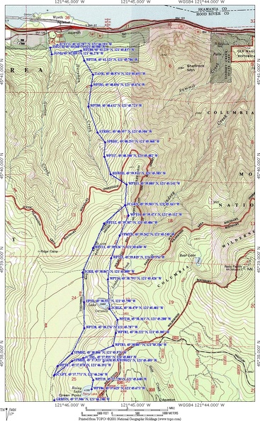
Trail Maps:
Topo Map, Trail #411 Forest Service Map, Download Garmin .gpx file
Review: July 11, 2009
From the trailhead, walk about 500 feet and turn left at the first 4-way junction. You’ll know where to turn because there is a nice log bridge on the right for Trail #400.
The trail climbs about 50 feet above the parking lot as it skirts the end of a ridge. Then the trail drops down and meets a small way trail that leads to the campground. The trail climbs again and crosses underneath, and parallels powerlines for a short distance, then enters a forest of Douglas Fir and Maples with the understory consisting of Vine Maple, Alder, and Poison Oak along with Oregon Grape, Ducks Foot, Thimbleberry and wild roses.
The trail begins to climb along the west bank of Harphan Creek for a short distance, then drops down and crosses the creek. Most of the year this is an easy step-across creek. As always, watch out for wet, slippery, slime covered rocks at stream crossings.
After the first few miles you may be wondering where the rest of the switchbacks are because it seems like there are several missing. This trail is quite steep and has a high sweat index. In one of the switchbacks if look off to the left you’ll see an old steel tank, which was probably used to store water.
From here, continue climbing the steep switchbacks up the forested slopes. Finally, after an hour or more, the switchbacks level out a bit, then the trail turns away from the Gorge, and goes up the Harphan Creek Valley and the roadside sounds slowly die away.
Walking a short distance farther there are a couple of nice logs to sit underneath the trees and take a break.
After about 1.75 miles, the trail comes up to a stream and switchbacks to the left. This would be a nice place to filter water if you needed it. The stream crosses the trail farther up the hillside.
After about 2.25 miles, the trail crosses a small stream that is a tributary of Harphan Creek. This is a good place to get water and is a welcome respite from the climb.
Shortly after the stream, the trail rounds a corner and opens up to the first good view of the Gorge looking to the northwest. Stop a while to take a short break and enjoy the views.
After about 3.25 miles and walking almost 3 hours, you come to the lower junction of Green Point Ridge trail and the plateau cutoff trail. Take the Plateau Cutoff Trail that goes to the left, towards North Lake.
The trail levels out just before the junction to Green Point Ridge and then descends for a while along the ridge, crossing a boulder field, giving you an unobstructed view of Mt. Defiance to the east. You can tell it is Mt. Defiance because of the radio tower on the top. The trail goes back into the woods and continues to gently descend towards North Lake.
There are a few trails around North Lake but you need to make your way to the junction of Wyeth and Rainy Lake Trail or choose this point to turn around and retrace your steps.
Rainy Lake looks like it is a fairly shallow man-made lake. There isn’t any view of any surrounding mountains from the shore. Once you climb up to the lake on the trail and head towards Rainy Lake the trail is fairly level and perhaps a bit more used because of the nearby road.
The trail to Rainy Lake crosses a couple of damp areas and you’ll see cedar trees growing in these area because they flourish in wetter soil and also this part of the trail is very brushy but you can find the trail as long as you pay attention to where the trail goes.
After you go about another mile, you come to the junction for Rainy Lake and the Ridge Trail. Head straight ahead at the junction to go to Rainy Lake. This area seems to have a lot more mosquitoes than North Lake and they are hungry early in the season.
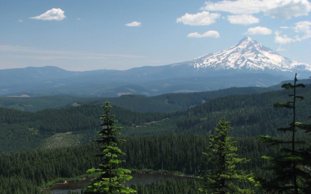
Looking across Rainy Lake to the southwest, you’ll see nice view of a volcanic formation that is Green Point Mountain.
Coming back from Rainy Lake, take the Gorton Creek Trail, make a left, and immediately start climbing up to the ridge. There are a couple of nice views of Mt. Hood as you cross a rockfield. Looking to the east you can see into the Mt. Hood Valley above Hood River and a forest of trees, no clear-cuts at all.
After climbing up, you arrive at a 4-way junction and take the trail on the right, which is the Green Point Ridge Trail Plateau Cutoff. Walking along the ridge there are a few places where you can go off the trail to the right and get views of Rainy Lake and Mt. Hood. If you wander off the trail for any reason, it would be wise to count your paces so that you don’t overshoot the narrow trail and get lost.
The ridgetop is fairly wide and flat and the trail meanders a bit along the top. As you proceed north, there are views of North Lake along the east edge of the ridge. The Ridge Trail continues to meander along the top of the ridge and passes a couple of viewpoints just off the trail on the east side. Once you reach the junction of the Ridge Trail, the trail descends more steeply off the ridge down to the Wyeth Trail.
This trail is reasonably well maintained with most of the deadfall has been cleared from the trail. The trail here is fairly faint and doesn’t see much use so if you like solitude on the trails, this is one for you.
On the way back down you’ll be wishing for those missing switchbacks again, the ones they forgot to put into the trail as your knees ache and your quads burn on the last 1.5 miles of the trail.
About 200 feet after the powerlines is the little way trail that goes off to the right, into campground. If you need to use the restroom, this is the trail to take and the waypoint is JCTCG.
From the bathrooms, make a left and walk back uphill to the trailhead parking lot.
This trail is for experienced hikers due to the unrelenting ascent for the first few miles of the trail. Dogs should have a good time on this trail because of the stream crossings and lakes.
Enjoy the photos!!
Gallery Pics
Switchback Steve
Recent Comments