Eyehike Gallery

Welcome to the Eyehike photo gallery

בית / Fire Lane 12 Photos OR /

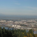
The new Sauvie Island Bridge taken from near the junction of the BPA Road and Fire Lane 13.

aag.jpg Picture of the end of Fire Lane 13 showing the power poles that mark the start of the user trail. You can see the user trail going off into the brush just to the right of the poles.צלמיותA wider angle of view showing Mt. St. Helens on the left and Mt. Adams on the right, behind the Portland industrial area taken from near the junction of the BPA Road and Fire Lane 13.Picture of the end of Fire Lane 13 showing the power poles that mark the start of the user trail. You can see the user trail going off into the brush just to the right of the poles.צלמיותA wider angle of view showing Mt. St. Helens on the left and Mt. Adams on the right, behind the Portland industrial area taken from near the junction of the BPA Road and Fire Lane 13.Picture of the end of Fire Lane 13 showing the power poles that mark the start of the user trail. You can see the user trail going off into the brush just to the right of the poles.צלמיותA wider angle of view showing Mt. St. Helens on the left and Mt. Adams on the right, behind the Portland industrial area taken from near the junction of the BPA Road and Fire Lane 13.Picture of the end of Fire Lane 13 showing the power poles that mark the start of the user trail. You can see the user trail going off into the brush just to the right of the poles.צלמיותA wider angle of view showing Mt. St. Helens on the left and Mt. Adams on the right, behind the Portland industrial area taken from near the junction of the BPA Road and Fire Lane 13.Picture of the end of Fire Lane 13 showing the power poles that mark the start of the user trail. You can see the user trail going off into the brush just to the right of the poles.צלמיותA wider angle of view showing Mt. St. Helens on the left and Mt. Adams on the right, behind the Portland industrial area taken from near the junction of the BPA Road and Fire Lane 13.Picture of the end of Fire Lane 13 showing the power poles that mark the start of the user trail. You can see the user trail going off into the brush just to the right of the poles.צלמיותA wider angle of view showing Mt. St. Helens on the left and Mt. Adams on the right, behind the Portland industrial area taken from near the junction of the BPA Road and Fire Lane 13.

aag

יוצר
Steve Jones
ביקורים
1321
ציון דירוג
ללא דירוג
דרג תמונה זאת

EXIF Metadata

Make
Canon
Model
Canon PowerShot S3 IS
DateTimeOriginal
2008:10:24 16:27:17
ApertureFNumber
f/3.5