Eyehike Gallery

Welcome to the Eyehike photo gallery

Inicio /

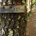
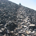
There are clearings along the trail where there are views to the south and the west of the mountains and valleys of the Coast Range.

aaf.jpg There are elevation signs every 1,000 feet to show how high you have climbed up towards the summit of 3,226 feet on the King's Mountain Trail in the Tillamook State Forest, Oregon.MiniaturasThe trail to Chinidere Mountain.There are elevation signs every 1,000 feet to show how high you have climbed up towards the summit of 3,226 feet on the King's Mountain Trail in the Tillamook State Forest, Oregon.MiniaturasThe trail to Chinidere Mountain.There are elevation signs every 1,000 feet to show how high you have climbed up towards the summit of 3,226 feet on the King's Mountain Trail in the Tillamook State Forest, Oregon.MiniaturasThe trail to Chinidere Mountain.There are elevation signs every 1,000 feet to show how high you have climbed up towards the summit of 3,226 feet on the King's Mountain Trail in the Tillamook State Forest, Oregon.MiniaturasThe trail to Chinidere Mountain.There are elevation signs every 1,000 feet to show how high you have climbed up towards the summit of 3,226 feet on the King's Mountain Trail in the Tillamook State Forest, Oregon.MiniaturasThe trail to Chinidere Mountain.There are elevation signs every 1,000 feet to show how high you have climbed up towards the summit of 3,226 feet on the King's Mountain Trail in the Tillamook State Forest, Oregon.MiniaturasThe trail to Chinidere Mountain.

aaf

Autor
Steve Jones
Visitas
1196
Puntuación
no valorada
Valorar

Metadatos EXIF

Make
Canon
Model
Canon PowerShot S3 IS
DateTimeOriginal
2008:11:30 09:38:45
ApertureFNumber
f/4.0