Eyehike Gallery

Welcome to the Eyehike photo gallery

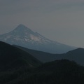
Home / Ruckel Ridge Photos OR /

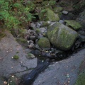
This is the next water source heading south after leaving the Benson Plataeu.

aap.jpg Mt. Hood viewed from a scree field just north of the Benson Plateau. Smoke from the Gnarl Ridge fire of 2008 clouds the view.ThumbnailsRuckel Creek where the trail meets the Columbia State Highway Historic Trail.Mt. Hood viewed from a scree field just north of the Benson Plateau. Smoke from the Gnarl Ridge fire of 2008 clouds the view.ThumbnailsRuckel Creek where the trail meets the Columbia State Highway Historic Trail.Mt. Hood viewed from a scree field just north of the Benson Plateau. Smoke from the Gnarl Ridge fire of 2008 clouds the view.ThumbnailsRuckel Creek where the trail meets the Columbia State Highway Historic Trail.Mt. Hood viewed from a scree field just north of the Benson Plateau. Smoke from the Gnarl Ridge fire of 2008 clouds the view.ThumbnailsRuckel Creek where the trail meets the Columbia State Highway Historic Trail.Mt. Hood viewed from a scree field just north of the Benson Plateau. Smoke from the Gnarl Ridge fire of 2008 clouds the view.ThumbnailsRuckel Creek where the trail meets the Columbia State Highway Historic Trail.Mt. Hood viewed from a scree field just north of the Benson Plateau. Smoke from the Gnarl Ridge fire of 2008 clouds the view.ThumbnailsRuckel Creek where the trail meets the Columbia State Highway Historic Trail.

aap

Author
Steve Jones
Visits
955
Rating score
no rate
Rate this photo